
Latitudes are imaginary lines running parallel to the ............... .
- Tropic of Cancer
- Equator
- Prime Meridian
- Arctic Circle
Answer
Equator
The art of drawing maps is called ............... .
- a cartographer
- an atlas
- a sketch
- cartography
Answer
cartography
The direction halfway between north and east is called the
- northwest.
- southwest.
- northeast.
- southeast.
Answer
northeast.
Political and physical maps are
- large-scale maps.
- small-scale maps.
- both i and ii
- none of these
Answer
small-scale maps.
To show the details of a town or a city, one of the following maps is needed.
- a small-scale map
- a large-scale map
- a physical map
- all of these
Answer
a large-scale map
Identify A and B in the diagram.
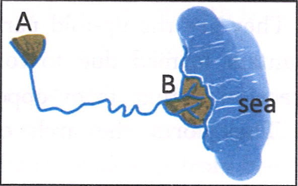
- A—a distributary, B—a tributary
- A—a lake, B—a river
- A—a tributary, B—a sea
- A—a tributary, B—a distributary
Answer
A—a tributary, B—a distributary
Which feature helps you to identify the mountain as a block mountain?
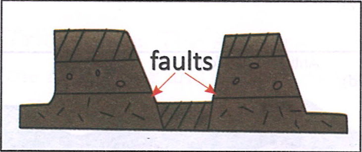
- It has hard rocks.
- It has flat-topped portions which are separated by two faults.
- It has a deep valley.
- It has horizontal beds.
Answer
It has flat-topped portions which are separated by two faults.
Look at the given sketch. Match List I with List II and select the correct answer using the codes given below:
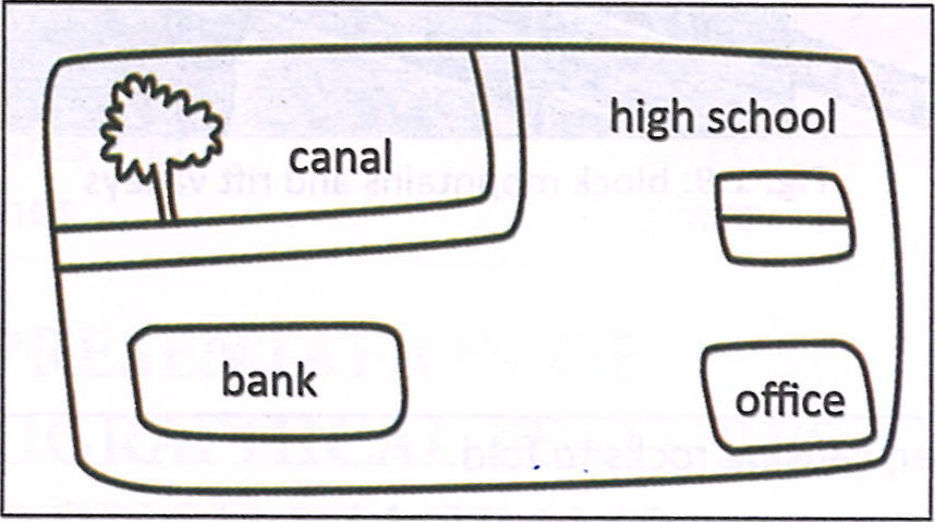
| List I | List II |
|---|---|
| A. bank | 1. northwest |
| B. high school | 2. southeast |
| C. office | 3. northeast |
| D. tree | 4. southwest |
Choose the right option for the directions given in the sketch:
- A-4, B-3, C-2, D-1
- A-2, B-1,C-3, D-4
- A-2, B-3, C-4, D-1
- A-4, B-1, C-2, D-3
Answer
A-4, B-3, C-2, D-1
Identify the incorrect statement about maps.
- Maps are drawn to scale.
- Maps cannot be drawn quickly from one's memory.
- Maps show directions based on the North Line.
- Maps give a rough picture of the Earth.
Answer
Maps give a rough picture of the Earth.
Two statements are given in the question below as Assertion (A) and Reason (R). Read the statement and choose the appropriate option:
Assertion (A): Maps showing continents are drawn on small-scale maps.
Reason (R): Small-scale maps require less scaling down.
Choose the correct option:
- A is true but R is wrong.
- A is false but R is true.
- Both A and R are true but R is not the correct explanation of A.
- Both A and R are true and R is the correct explanation of A.
Answer
Both A and R are true and R is the correct explanation of A.
Explanation — Maps showing continents are drawn on a small-scale as it requires less scaling down.
A large natural stream of water that flows from higher to lower ground
Answer
River
The small rivers that join the main river and enlarge its volume
Answer
Tributaries
The triangular-shaped alluvial deposits near the mouth of the river
Answer
Deltas
The up-fold part of a fold mountain
Answer
Anticline
The depressed part between two block mountains
Answer
Rift valley
State whether the following statements are 'true' or 'false'. Correct and rewrite the false statements.
- Maps are never drawn to a scale.
- Plans do not take too much time to prepare.
- The type of information that a map shows determines its title.
- A scale of 1:400 is used in a small-scale map.
- The four directions—north, south, east and west—are called the intermediate directions.
Answer
False
Correct Statement — Maps are always drawn to a scale.True
True
False
Correct Statement — A scale of 1:400 is used in a large-scale map.False
Correct Statement — The four directions—north, south, east and west—are called the cardinal directions.
What is a globe? How is a globe useful?
Answer
A globe is a three-dimensional, accurate model of the Earth, showing the location and shape of continents and oceans. It rotates on a stand and helps in locating places precisely with the help of latitudes and longitudes.
What is a map? Why is a map important? What are the different elements of a map?
Answer
A map represents the world as a whole or a part of it, usually on a flat surface. It is thus a visual representation of the Earth on a flat surface.
Importance of Maps
- They are a source of knowledge and accurate information about places, for students and teachers.
- They are also used by navigators and travellers to find the direction to their destinations.
- They are used by town planners for town planning.
- They show a lot of detail and are very informative. They may show political divisions, physical features, natural vegetation or population distribution with appropriate colours and symbols. They are, therefore, useful for administrators and the military.
Elements of a map
There are five elements of a map — title, scale, the North Line, grid and legend.
- Title: The type of information that a map shows determines its title.
- Scale: A scale is the proportion or ratio between the distance on a map and the corresponding distance on the ground, or the Earth's surface.
- North Line: This symbol (↑N) indicates the north direction and helps us to find the direction of any place on the map.
- Grid: Grids are regular horizontal and vertical lines. They help in finding places on the map. The horizontal lines are northings while vertical lines are eastings.
- Legend or index: It includes the various symbols and colours used in a map and helps us to interpret the information being provided by the map.
Write two points to support that maps are better than globes.
Answer
Maps are better than globes in the following ways:
- A map is easy to handle as it can be folded or rolled. Hence, it can be carried everywhere, which is not the case when we talk about a globe.
- Maps are very informative as they show more details of small areas. However, globes cannot show such small details like details of a city or a state or distribution of various resources.
Why is a scale used in a map?
Answer
A scale is the proportion or ratio between the distance on a map and the corresponding distance on the ground, or the Earth's surface. Hence, it helps us to draw large areas of the ground accurately on a small map. Distances may be measured using the statement of scale or the graduated straight line on the map.
Explain why a map with a scale of 1 cm to 100 km is a small-scale map.
Answer
A map with a scale of 1 cm to 100 km is called a small-scale map because a small unit of 1 cm on the map represents a very large distance of 100 km on the ground. Such maps show a large area with limited detail, highlighting only major features like countries, states, or large cities, not finer local details.
Why are conventional symbols necessary?
Answer
Since a map represents a part of the Earth's surface in a small size, the space available on it is limited. Many features such as rivers, roads and settlements have to be shown on the map in the available limited space. Therefore, these features are depicted by a set of symbols called conventional symbols.
Why is a sketch used? Give two reasons.
Answer
Two reasons to use a sketch are as follows:
- A sketch shows relevant details only but not all features, i.e. it gives us a rough idea of the route between two places.
- It is mostly used for showing small areas randomly. Hence, a sketch can be drawn quickly from one's memory.
Where will you use a plan? Give a reason.
Answer
A plan is used to show detailed information about a small area, such as a school. For example, a school plan helps us see the exact layout of classrooms, offices, playgrounds, and other facilities. This is because a plan is drawn to a large scale, allowing us to include precise details that wouldn’t be visible on a regular map.
Answer the following questions based on the sketch of a town:

- To which direction is the shopping plaza from the park?
- In which direction will you move from school to go to Block C?
- In which direction is the garden from Block B?
- In which direction will you move from the Shopping Plaza to reach Block C?
- In which direction is the park from the Statesman House?
Answer
The Shopping Plaza lies southeast to the Park.
To go to Block C from School, I will move in northeast direction.
The Garden lies to the south of Block B.
To reach Block C from the Shopping Plaza, I will move in northwest direction.
The Park lies to the northwest of the Statesman House.
You are helping your parents in buying a new apartment. What would you suggest they refer to — a map or a plan of the apartment? Discuss with your classmates and give reasons for your answer.
Answer
I would suggest my parents to refer to a plan of the apartment, and not a map.
This is because a plan would show the exact layout of the apartment including room sizes, arrangement, and entrances. It helps in making practical decisions like furniture placement, room utility, and space planning. A map would only be useful to see the location of the building, and not provide the specific details of the apartment inside.