Fill in the blanks
- The difference in elevation between successive contours is called ....................
- When contours are drawn close together they show ................... slope.
- Nomadic movement is not migration as it is ....................
- A disaster is a sudden ................... that may cause displacement of great number of people.
- Yak is found in the cold desert of ....................
Answer
- contour interval
- steep
- seasonal
- calamity
- Tibetan plateau
Match the following
| Column 1 | Column 2 |
|---|---|
| Densely populated region in Asia | Retreating Monsoon |
| Withdrawal of Monsoon | Marusthali |
| Xerophytic Forests | Japan |
| Great Indian Desert | Gulf of Cambay |
| Kutchh | Deserts |
Answer
| Column 1 | Column 2 |
|---|---|
| Densely populated region in Asia | Japan |
| Withdrawal of Monsoon | Retreating Monsoon |
| Xerophytic Forests | Deserts |
| Great Indian Desert | Marusthali |
| Kutchh | Gulf of Cambay |
Human resource resides in the
- Knowledge
- Skill
- Motivation
- All of these
Answer
All of these
In India, in 2011, the rural population was about
- 28.30%
- 38.48%
- 48.68%
- 68.84%
Answer
68.84%
The satellite city of Kolkata
- Sunbury
- Salt lake city
- Panchkula
- None of these
Answer
Salt lake city
Various types of migration depend on the
- Number of people often involved
- reason for movement
- nature of migration
- all of these
Answer
all of these
Answer in one word
(i) An amount of money sent as a gift to someone.
Answer
Remittances
(ii) Movement from one country to another country.
Answer
Immigration
(iii) The ranges located along the eastern boundary of India.
Answer
Purvanchal range
(iv) A big geographical region forming a well defined geographical unit.
Answer
Sub-continent
(v) The plain that extends from Sadiya in the east to Dhubri in the west.
Answer
The Brahmaputra plain
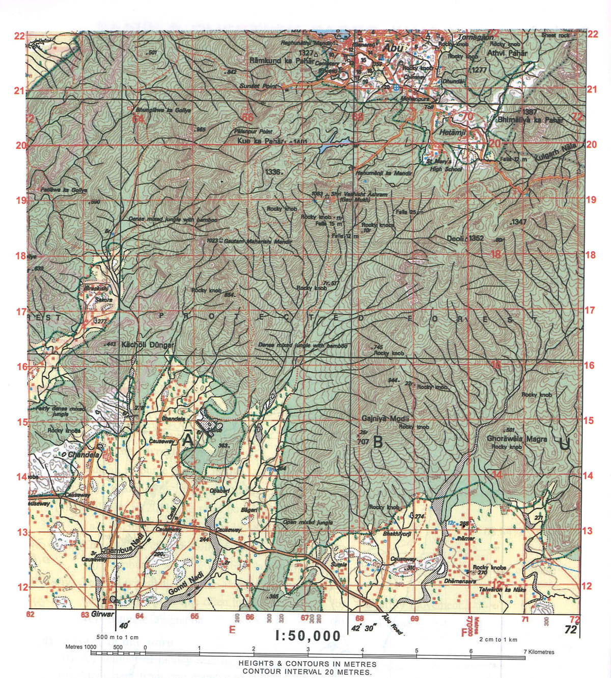
Study the survey of India toposheet G43S10 given and answer the following questions.

(i) Which is the largest settlement? Name and identify it.
(ii) Identify a steep slope shown on the map and give four figure grid reference of the same.
(iii) In what colour are contour shown on the map? What is meant by Index contours?
(iv) Name the settlement patterns shown in the given survey sheet. Why is Abu an important town?
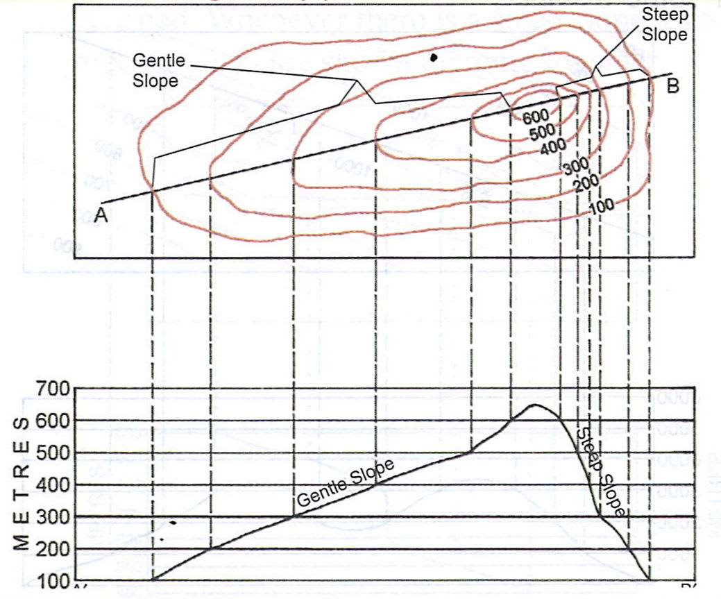
(v) Draw a neat diagram of gentle slope and steep slope.
Answer
(i) Abu is the largest settlement.
(ii) Grid reference 7120 shows a steep slope.
(iii) Contours are shown with brown colour on the map.
The ordnance survey maps of 1:50,000 scale have contours drawn at the vertical interval of 20 m. Although the contour interval is 20 m, in the topographical maps one finds the heights shown as 100 m. To make the contour maps distinct, every fifth line in multiple of 20 m is accentuated and this is called Index contour.
(iv) The settlement patterns shown in the given survey sheet are-
- Nucleated settlement
- Linear settlement
- Dispersed settlement
Abu is an important town as it contains the following facilities-
- It is well connected by roads.
- It has temples.
- It has a dispensary.
- It has a police station.
(v) Below is the contour diagram showing a gentle slope and steep slope:

What is meant by density of population? How is it measured?
Answer
The total number of people in a country in relation to its land, is known as population density.
It can be measured as follows-
Population density = Total population of a country / Total land area of the country
State the advantages of migration to destination country.
Answer
The advantages of migration to destination country are-
- Availability of cheap labour
- Availability of skilled labour
- Cultural diversity
Explain briefly the causes of Brain Drain in India.
Answer
The causes of brain drain in India are-
- Absence of research facilities
- Employment discrimination
- Economic underdevelopment
- Lack of freedom
- Poor working conditions
- Lack of job opportunities
- Discriminating cultures
- Political intolerance
Define a disaster. State any two effects of disaster.
Answer
A disaster can be defined as a sudden, accidental event of great magnitude that causes considerable damage to life and property.
Two effects of disaster are-
- Loss of life and property
- Displacement of people affected by the disaster
State the latitudinal extent of India.
Answer
The latitudinal extent of India is approximately 8°N to 37°N.
What is meant by human resource?
Answer
Human resource can be defined as the resource that resides in the knowledge, skills and motivation of the people.
What is meant by the term peninsula? Why is India called so?
Answer
The term peninsula means a tract of land having water on three sides.
The Indian plateau is called so because it is surrounded by water bodies on three sides-
- The Indian ocean in the south
- The Arabian sea in the west
- The Bay of Bengal in the east
How do Himalayas affect the climate of Asia?
Answer
The east west trend of Himalayas in South Asia, prevents the cold winds from Central Asia to enter the subcontinent in winter. They force the monsoon winds to shed their moisture in the south during the rainy season.
Name the countries which are included in Indian sub-continent.
Answer
India, along with its neighbouring countries, Pakistan, Bangladesh, Bhutan, Nepal, Sri Lanka and Maldives, is called the Indian subcontinent.
What is meant by population pyramid?
Answer
A population pyramid is a graphical representation that shows the distribution of various age groups and gender in a population.
How do forests help in conserving our wildlife and ecobalance in nature?
Answer
Forests are the natural habitat of a large variety of wildlife. Wildlife refers to the animal species that are not domesticated. So, any living organism that lives in the forest region is associated with wildlife. It is found in almost all ecosystems such as rain forests, boreal forests, plains, grasslands, deserts etc. Wildlife provides great stability to our environment wherein they are involved in natural processes either directly or indirectly. Each living organism is placed in the food chain and is equally important, they may be a producer, a consumer or a decomposer, all these are interlinked and depend on each other for their survival. Since, forests provide a habitat to wildlife, they help in conserving our wildlife.
Animals release carbon-dioxide during respiration which is absorbed by plants. On the other hand, plants release oxygen during the process of photosynthesis. In this way the oxygen and carbon dioxide cycle goes on. Since forests contain a large number of plants and trees, they help in maintaining the balance between oxygen and carbon dioxide in the atmosphere.
Forests also affect the climate of a place by regulating the temperature and rainfall of the area. They prevent soil erosion as well. Hence, forests help in balancing our ecosystem.
What is meant by a rain shadow area?
Answer
A rainshadow area describes the dry area on one side of a mountain or mountain range where less rain falls. This side of the mountain or mountain range is called the leeward side, while the side which has greater rainfall is called the windward side.
Differentiate between Skilled and Unskilled labour
Answer
| Skilled labour | Unskilled labour |
|---|---|
| It refers to the persons who are trained, well educated, energetic, experienced, devoted to their field. | It refers to the person who possesses no special training and whose work involves the performance of simple duties. |
| Skilled human resource is capable of doing any specific work in a balanced way and efficiently. | It is a workforce associated with limited skill or minimal economic value for the work performed. |
| For example, teachers, lawyers, doctors, engineers etc. | For example, peon, watchman, cleaner, sweeper, gardener, labourer etc. |
Differentiate between Immigration and Emigration
Answer
| Immigration | Emigration |
|---|---|
| When someone moves to a country from another place, it is known as Immigration. | When someone moves out of a particular place, it is known as Emigration. |
| When a person immigrates to a country its population increases. | When a person emigrates from a country, its population shrinks. |
Differentiate between National park and Sanctuary with examples.
Answer
| National Park | Sanctuary |
|---|---|
| Can include flora, fauna or any other objects of historical/geographic significance. | The main aim is to protect a particular flora or fauna. |
| Boundaries are fixed and defined. | There are no fixed boundaries. |
| No human activities are allowed. | Human activities are allowed. |
| Not usually open to the public. | It is open to the general public |
| Sanctuaries are usually formed by the order of Central or the State Government | National Parks are formed by the state or central Legislature. |
| A national park cannot be downgraded to a sanctuary. | A sanctuary can be upgraded to a national park. |
Give reasons for the following:
In India rural to urban and urban to rural migration is important.
Answer
In India, rural to urban and urban to rural migration is important because rural to urban population provides labour to the industries in the urban areas. This labour sends remittances to their family in the rural areas and hence help in rural development.
Also, when people move from urban to rural areas, they bring new ideas with them. At times, the industrialists move to rural areas to set up factories, which provide employment to the rural people and help in raising their standard of living.
Give reasons for the following:
The ocean currents affect the climate of a region.
Answer
The cold and warm ocean currents affect the climate of a region. The climate of a region becomes cold if a cold current flows near it such as the cold Oyashio current washes the western coast of Japan and makes it extremely cold, whereas if a warm current flows near a region, the winter becomes milder, as is the case with eastern coast of Japan which is washed by the warm Kuroshio current.
Give reasons for the following:
The climate of Indonesia is equatorial type.
Answer
The climate of Indonesia is equatorial type because Indonesia lies near the equator and receives a large amount of rainfall due to hot and wet climate.