
What is the composition of the atmosphere?
Answer
The atmosphere is a blanket of air surrounding the Earth, held down by gravity, and is composed of a mixture of various gases:
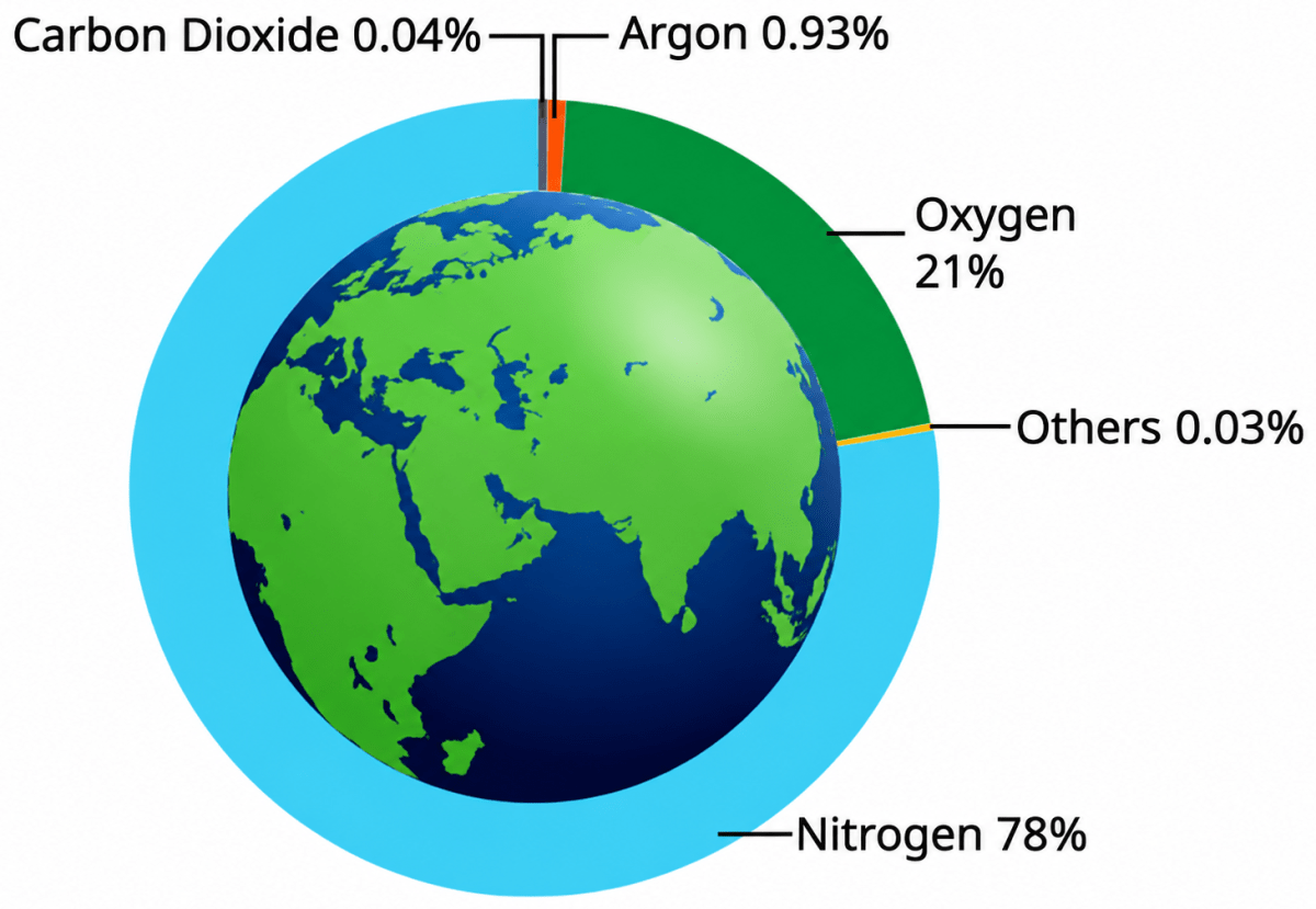
- Gases: Nitrogen (78%) and oxygen (21%) make up the vast majority of the air and are essential for life. The remaining fraction includes argon (0.93%), carbon dioxide (0.04%), and trace amounts (0.03%) of gases like helium, neon, krypton, xenon, ozone, and hydrogen.
- Water Vapour & Dust: Water vapour typically ranges from 0.1% to 0.4% of the atmosphere, playing a critical role in condensation and cloud formation.
The exact composition of gases and particles changes depending on altitude.
How do the different layers of the atmosphere affect the planet Earth?
Answer
The atmosphere is divided into distinct layers based on variations in temperature and density as altitude increases:
- Troposphere — Extending to an average height of about 12 km, this lowest layer contains the air we breathe, most of the water vapour, and clouds. Nearly all weather phenomena, such as rainfall, fog and hail, occur here.
- Stratosphere — Extending up to 50 km, this layer is free of clouds and other weather disturbances, making it ideal for flying aeroplanes. It contains the ozone layer, which filters the Sun's harmful radiation, including ultraviolet radiation.
- Mesosphere — Extending up to 80 km, this layer is where most meteorites entering from space burn up.
- Thermosphere — Extending from 80 km to 700 km, this layer absorbs X-rays and short-wave ultraviolet radiation from the Sun. It contains the ionosphere, helps in radio transmission by reflecting radio waves back towards the Earth, and is the region where auroras occur.
- Exosphere — The uppermost layer has very thin air. Light gases such as helium and hydrogen can escape into space from this layer.
What is the mechanism of monsoon?
Answer
Monsoon refers to the seasonal shift in wind direction over the course of a year, driven by the unequal heating and cooling of land versus sea.
- South-west monsoon (summer monsoon) — From June to September, the Indian subcontinent heats up much faster than the surrounding ocean, creating low atmospheric pressure over land and higher pressure over the sea. Moist winds blow from the Indian Ocean, Arabian Sea, and Bay of Bengal toward the low-pressure landmass, generating the majority of India's annual rainfall.
- North-east monsoon (winter monsoon) — From October to February, the landmass cools down faster than the ocean, building high pressure over land and low pressure over the sea. Dry, cool winds blow out from land to sea. As these winds cross the Bay of Bengal, they collect moisture and bring rain to the south-eastern coast, such as Tamil Nadu, Andhra Pradesh, and parts of Karnataka.
How can we reduce our carbon footprint?
Answer
A carbon footprint represents the total greenhouse gas emissions generated by human actions like energy consumption, transport, and manufacturing. We can lower it through the following practices:
- Saving energy — switching off lights, fans and other electrical appliances when they are not in use.
- Using renewable sources of energy in place of fossil fuels.
- Walking, cycling, or using public transport and carpooling instead of travelling by private cars for short distances.
- Using water judiciously and avoiding its wastage.
- Reusing and recycling materials, and avoiding single-use plastics.
- Planting trees, protecting forests and adopting eco-friendly lifestyles.
Can you imagine what would happen if there were no atmosphere? Discuss your thoughts with your friends and teachers.
Answer
If there were no atmosphere:
- Living organisms would suffocate without air.
- Earth would lose its protective shield against harmful solar radiation, including ultraviolet rays.
- Temperatures would become extreme, with very hot days and very cold nights because the atmosphere would no longer regulate the Earth's temperature.
- Weather phenomena like rain, clouds, fog, air pressure, and wind would cease completely.
- Meteors from space would collide directly with the planet's surface without burning up.
You might have noticed that sometimes the wind is so strong that it is difficult to walk against it. Can you think of some other times when strong winds have caused problems for you?
Answer
Some occasions when strong winds have caused problems are:
- Strong winds can uproot trees and break branches, blocking roads.
- Dust blown by strong winds can enter the eyes and make it difficult to see while walking or cycling.
- Strong winds can blow away dry leaves, papers and other light objects.
- Umbrellas can turn inside out and become difficult to hold on windy, rainy days.
- Strong winds can damage hoardings, tin roofs and electric wires, causing power disruptions.
Hindustani Classical music associates certain rāgas with specific seasons. Find out which rāgas are connected to each season with the help of your elders and teachers.
Answer
Sample answer
Some commonly cited seasonal associations in Hindustani Classical music are:
| Season | Examples of associated rāgas |
|---|---|
| Vasanta (spring) | Rāga Basant, Rāga Bahār, Rāga Hindol |
| Grīṣhma (summer) | Rāga Deepak, Rāga Sarang |
| Varṣhā (monsoon) | Rāga Miyan ki Malhar, Rāga Megh, Rāga Megh Malhar |
| Śharad (early autumn) | Rāga Bhairav, Rāga Jaunpuri |
| Hemanta (late autumn) | Rāga Bageshri |
| Śhiśhira (winter) | Rāga Malkauns, Rāga Darbari Kanada |
The exact seasonal associations may vary across musical traditions.
How is nitrogen useful for plants? Remember that you learnt this in the chapter 'The Invisible Living World: Beyond Our Naked Eyes', in your Grade 8 Science textbook.
Answer
Nitrogen is essential for plants because it is needed to make proteins, chlorophyll and other substances required for their growth. However, plants cannot use the nitrogen gas of the atmosphere directly. Nitrogen-fixing bacteria, such as those living in the root nodules of leguminous plants, convert atmospheric nitrogen into nitrogen compounds like nitrates, which plants can absorb from the soil through their roots.
Find out other categories of wind based on speed and their common effects, and share your findings in class.
Answer
Using the Beaufort scale, some additional wind categories are:
| Wind | Speed (km/h) | Common Effects |
|---|---|---|
| Light air | 1–5 | Smoke drifts slowly, but a wind vane does not move. |
| Gentle breeze | 12–19 | Leaves and small twigs move constantly; light flags are extended. |
| Moderate breeze | 20–28 | Dust and loose paper are raised; small branches move. |
| Fresh breeze | 29–38 | Small trees begin to sway; crested wavelets form on inland waters. |
| Near gale | 50–61 | Whole trees are in motion; it becomes difficult to walk against the wind. |
| Gale | 62–74 | Twigs break off trees; walking becomes very difficult. |
| Strong gale | 75–88 | Slight structural damage occurs; roof tiles may be blown off. |
| Storm | 89–102 | Trees may be broken or uprooted; structural damage occurs. |
| Violent storm | 103–117 | Widespread damage occurs. |
| Hurricane | 118 and above | Devastating and widespread destruction. |
Describe in your own words how monsoon affects the lives of the people around you.
Answer
Monsoon plays a vital role in the lives of people in India:
- Most of India's agriculture depends on monsoon rainfall, as farmers rely on rain for sowing and growing crops.
- A good monsoon ensures sufficient food production and water supply in rivers, reservoirs and wells.
- Monsoon also affects daily life, transport, festivals and employment, especially in rural areas.
- However, excessive rainfall can cause floods, while weak monsoons can lead to droughts.
My Carbon Footprint
Step 1: My Daily Habits — Tick the options that best describe you.
A. Transport
- I usually walk/use a cycle. (Low impact)
- I use public transport/carpool. (Medium impact)
- I travel by private cars even for short distances. (High impact)
- I take flights more than twice a year. (Very high impact)
B. Electricity Use
- I always switch off electrical appliances (lights, fans, etc.) when not in use. (Low impact)
- I sometimes forget to switch off electrical appliances (lights, fans, etc.). (Medium impact)
- I leave electrical appliances (lights, fans, etc.) on frequently. (High impact)
C. Water Use
- I use water judiciously, for example, just one bucket of water for bathing. (Low impact)
- I sometimes waste water (leaving the tap running/more buckets of water for a bath/long showers). (Medium impact)
- I rarely think about saving water. (High impact)
D. Waste and Plastics
- I reuse, recycle, and avoid single-use plastics. (Low impact)
- I sometimes use disposable plastics (bottles/bags/straws). (Medium impact)
- I often throw away plastic and do not recycle. (High impact)
Step 2: Score Yourself
- Low impact choices = 1 point
- Medium impact choices = 2 points
- High impact choices = 3 points
- Very high impact choices = 4 points
Now add up your total score: ............... points
Step 3: My Climate Action Pledge — Think about two simple changes you can make to reduce your score, and write them down below.
- ...............
- ...............
Answer
Step 1: My Daily Habits
| Category | Option ticked | Impact | Points |
|---|---|---|---|
| A. Transport | I use public transport/carpool. | Medium | 2 |
| B. Electricity Use | I sometimes forget to switch off electrical appliances. | Medium | 2 |
| C. Water Use | I use water judiciously, for example, just one bucket of water for bathing. | Low | 1 |
| D. Waste and Plastics | I sometimes use disposable plastics (bottles/bags/straws). | Medium | 2 |
Step 2: Score Yourself
Total score = 2 + 2 + 1 + 2 = 7 points
Step 3: My Climate Action Pledge
- I will switch off all lights, fans and other electrical appliances every time I leave a room.
- I will carry a reusable cloth bag and a steel water bottle so that I do not use disposable plastic bags, bottles or straws.
To what extent did natural factors cause these floods compared to human activities?
Answer
The Punjab floods of 2025 resulted from a combination of natural and human-made factors.
Natural causes — Very heavy monsoon rainfall, intensified by western disturbances, affected Punjab as well as Himachal Pradesh and Jammu & Kashmir. The Satluj, Beas, Ravi and Ghaggar were already flowing at high levels. Additional rainfall and water flowing down from the hills caused the rivers to overflow.
Human-made causes — Weak and old dhūsī bāndh (embankments), houses and farms built too close to rivers, and the accumulation of silt in rivers and dams reduced the capacity to hold and carry floodwater. In some areas, delayed or unclear warnings also left people less prepared.
Thus, natural factors caused the flooding, while human-made factors aggravated the damage and increased people's vulnerability.
Do you think better planning could have reduced the damage? How?
Answer
Yes, better planning could have reduced the damage considerably.
- Strengthening embankments — The weak and old river embankments (dhūsī bāndh) could have been repaired and strengthened in time so that they were able to hold back the rising water.
- Regulating construction near rivers — Houses and farms should not have been allowed too close to the rivers, so that the natural space where floodwater could spread safely was not reduced.
- Desilting rivers and dams — Removing the silt and mud collected in rivers and dams would have restored their capacity to hold and carry water.
- Timely early warning — Flood warnings should have been issued early and communicated clearly, so that people were prepared and could move to safety along with their belongings and livestock.
- Preparedness and relief planning — Relief camps, rescue equipment and medical supplies arranged in advance would have reduced the loss of lives, the spread of waterborne diseases and the sanitation problems that followed.
What are the guidelines for the management of floods according to the National Disaster Management Authority (NDMA)?
Answer
The NDMA's guidelines for flood management broadly cover the following measures:
- Prevention and structural measures — Building and maintaining embankments, dams and drainage channels, desilting rivers and reservoirs, and protecting natural drainage and catchment areas.
- Flood plain zoning and regulation — Restricting construction of houses, farms and important infrastructure in flood plains and near river banks.
- Flood forecasting and early warning — Expanding the network of forecasting stations and issuing timely, clear warnings that reach the people at risk.
- Preparedness and capacity building — Preparing flood-management plans, training rescue and relief teams, and creating public awareness through mock drills and community education.
- Response and relief — Timely evacuation of people and livestock, setting up relief camps, and providing safe drinking water, food, medicines and sanitation to prevent waterborne diseases.
- Rehabilitation and reconstruction — Repairing damaged roads, bridges and buildings, compensating affected families, and rebuilding in a way that reduces future flood risk.
What role can students/youth play in helping with disaster preparedness?
Answer
Students and young people can play an important role in disaster preparedness:
- Learning about local hazards such as floods and taking part in mock drills organised at school.
- Spreading awareness in their families and neighbourhoods about early-warning messages and safe evacuation routes.
- Helping to prepare an emergency kit at home with drinking water, food, torch, medicines and important documents.
- Discouraging the dumping of waste and plastics into drains and rivers, which blocks the flow of water.
- Volunteering with relief work — collecting clothes, food and other essentials for people in relief camps.
- Helping to spread correct information and stopping the spread of rumours during a disaster.
What is atmosphere? Explain its composition with the help of a pie diagram.
Answer
The atmosphere is the blanket of air surrounding the Earth by gravity. It shields the Earth from harmful solar radiation, including ultraviolet radiation, helps regulate temperature, and plays an important role in weather and climate.
The composition of the atmosphere is as follows:
- Nitrogen — 78%
- Oxygen — 21%
- Argon — 0.93%
- Carbon dioxide — 0.04%
- Others — 0.03% (helium, neon, krypton, xenon, ozone and hydrogen)
Besides these gases, the atmosphere also consists of water vapour (0.1 to 0.4 per cent) and tiny dust particles.
Draw a labelled diagram of the structure of atmosphere.
Answer
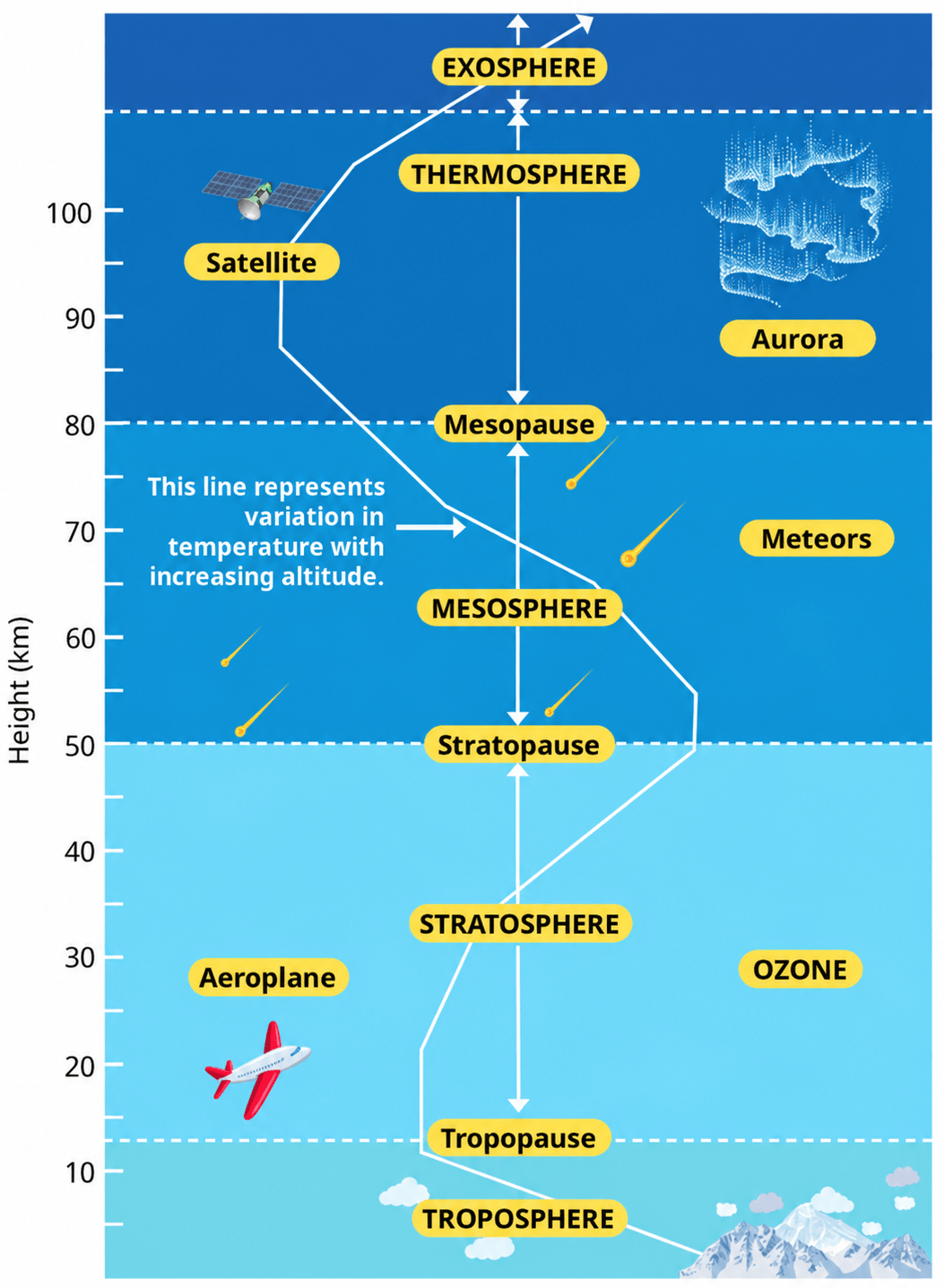
The atmosphere is divided into five main layers on the basis of changes in temperature and density with increasing altitude:
- Troposphere (0–12 km approximately): Contains most of the water vapour and clouds; nearly all weather phenomena occur here. The tropopause forms its upper boundary.
- Stratosphere (about 12–50 km): Contains the ozone layer and is largely free from weather disturbances. The stratopause forms its upper boundary.
- Mesosphere (about 50–80 km): Most meteorites burn up in this layer. The mesopause forms its upper boundary.
- Thermosphere (80–700 km): Contains the ionosphere, helps in radio transmission and is the region where auroras occur.
- Exosphere (above about 700 km): The uppermost layer, with very thin air and light gases such as helium and hydrogen.
Which are the four main seasons of India?
Answer
The Indian Meteorological Department (IMD) recognises four main seasons in India:
- Winter — December to early April
- Summer or pre-monsoon — April to June, extending up to July in north-western India
- Monsoon or rainy (Advancing monsoon) — June to September
- Post-monsoon (Retreating monsoon) — October to December
Why do you not feel the pressure of the atmosphere?
Answer
The air above us exerts a significant force on our bodies, and yet we do not feel it. This is because air presses on us from all sides, and our bodies exert a counter-pressure in response. The pressure inside our bodies is also equal to the atmospheric pressure and cancels the pressure from outside. Hence, we do not feel the pressure of the atmosphere.
In which layer of the atmosphere do aeroplanes fly and why?
Answer
Aeroplanes fly in the stratosphere, the layer that lies above the troposphere and extends up to 50 kilometres. This layer is ideal for flying aeroplanes because it is free of clouds and other weather disturbances, unlike the troposphere in which nearly all the weather phenomena such as rainfall, fog and hail occur.
Distinguish between the following:
(a) The troposphere and stratosphere
(b) The south-west monsoon and north-east monsoon
Answer
(a) The troposphere and stratosphere
| Troposphere | Stratosphere |
|---|---|
| It is the lowest layer of the atmosphere, lying immediately above the Earth's surface. | It lies above the troposphere and is separated from it by the tropopause. |
| It has an average height of about 12 kilometres. | It extends up to 50 kilometres. |
| Temperature decreases with increasing altitude in this layer. | Temperature generally increases with increasing altitude in this layer. |
| The air we breathe exists here, along with most of the water vapour and clouds. | It is free of clouds and other weather disturbances, which makes it ideal for flying aeroplanes. |
| Nearly all weather phenomena, such as rainfall, fog and hail, occur in this layer. | It contains a layer of ozone gas, which shields us by filtering the Sun's harmful radiation, including ultraviolet radiation. |
(b) The south-west monsoon and north-east monsoon
| South-west monsoon | North-east monsoon |
|---|---|
| It is also known as the summer monsoon. | It is also known as the winter monsoon. |
| It occurs between June and September. | It occurs from October to February. |
| Winds blow from sea to land across the Indian Ocean, the Arabian Sea and the Bay of Bengal. | Winds blow from land to sea. |
| The landmass of India heats up faster than the surrounding oceans, creating a low-pressure area over the subcontinent and high pressure over the ocean. | The Indian landmass cools faster than the surrounding oceans, creating a high-pressure area over the land and low pressure over the seas. |
| These winds are moist and bring rainfall. They account for most of India's annual rainfall. | These winds are cold and dry and generally do not bring rainfall to most parts of India. |
| It brings rainfall to most parts of the country. | After picking up moisture over the Bay of Bengal, these winds bring rainfall to the eastern coast, especially Tamil Nadu, Andhra Pradesh and parts of Karnataka. |
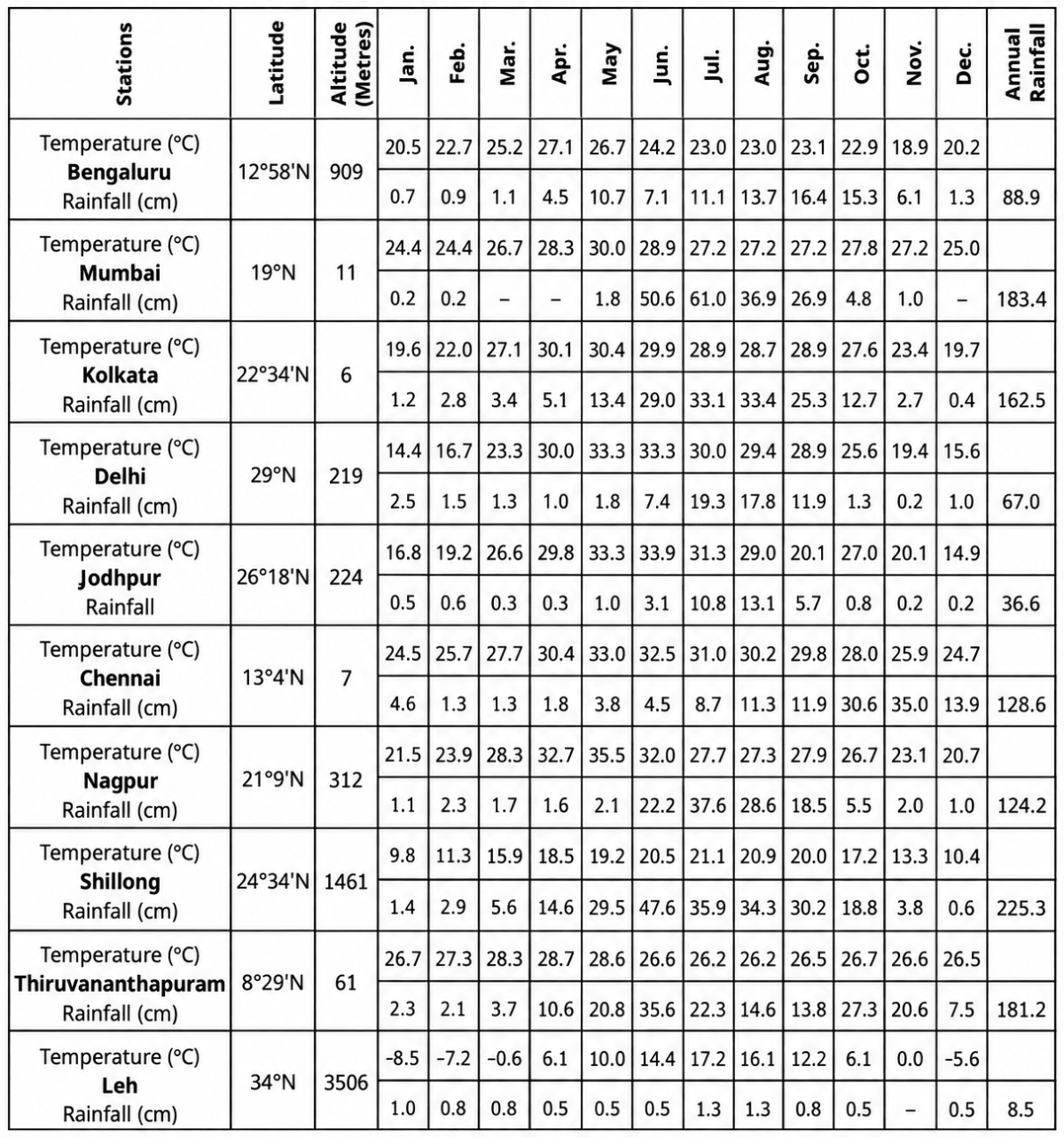
Do it yourself: Table 3.3 shows the average monthly temperatures and rainfall amounts for 10 representative stations. Study these figures on your own and convert them into 'temperature and rainfall' graphs. The visual representations will help you grasp their similarities and differences at a glance. One such graph (Fig. 3.14) is already prepared for you. See if you can arrive at some broad generalisations about our diverse climatic conditions.
Table 3.3. Average monthly temperatures and rainfall for 10 representative stations (temperature and rainfall data are representational)
Answer
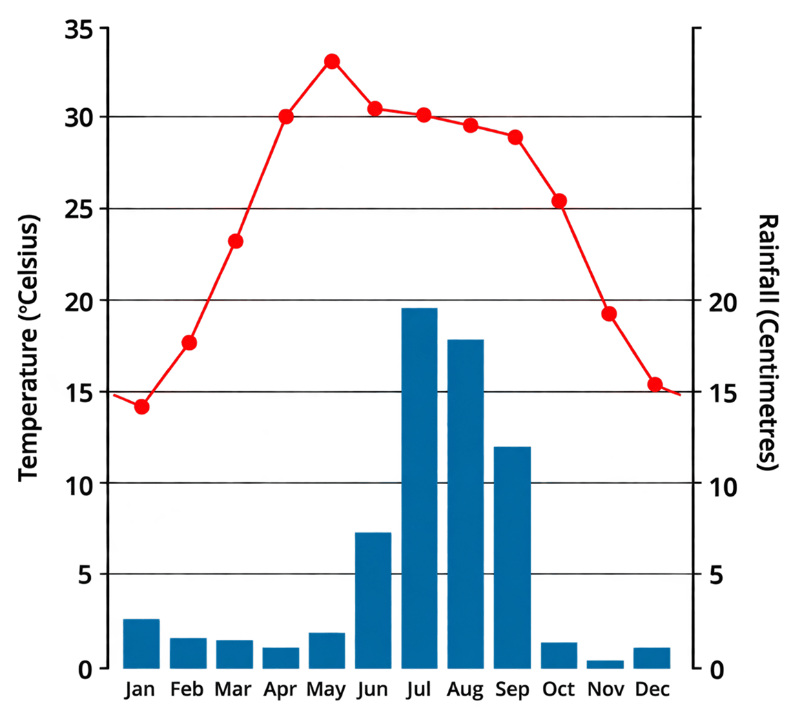
Broad generalisations from the graphs
- Temperature and latitude: Temperature generally decreases with increasing latitude. Southern stations such as Thiruvananthapuram and Chennai remain warm throughout the year, while Leh experiences very low winter temperatures.
- Altitude lowers the temperature — Altitude lowers temperature. High-altitude stations such as Shillong and Leh are considerably cooler than many lower-altitude stations.
- Coastal stations such as Thiruvananthapuram, Mumbai and Chennai have a small annual range of temperature, whereas inland stations such as Delhi, Jodhpur and Nagpur have a large one.
- In almost every station the rainfall bars are tallest between June and September, which is the season of the south-west monsoon.
- Chennai is the exception — its tallest bars fall in October and November, when the retreating (north-east) monsoon brings rainfall to the eastern coast.
- Rainfall is very unevenly distributed — Shillong and Mumbai receive very heavy annual rainfall, while Jodhpur and Leh receive very little.
Now look at Table 3.3 again. Re-arrange the 10 stations according to their distance from the equator.
Answer
The ten stations arranged in increasing order of their distance from the equator (that is, in increasing order of latitude) are:
Thiruvananthapuram (8°29'N) → Bengaluru (12°58'N) → Chennai (13°4'N) → Mumbai (19°N) → Nagpur (21°9'N) → Kolkata (22°34'N) → Shillong (24°34'N) → Jodhpur (26°18'N) → Delhi (29°N) → Leh (34°N)
Find out:
(a) Two stations with the most extreme climate.
(b) Two stations influenced by retreating monsoons.
(c) The two hottest stations in the months of (i) February (ii) June
Answer
(a) Two stations with the most extreme climate — Leh and Jodhpur
Leh has an annual temperature range of about 25.7°C (from –8.5°C in January to 17.2°C in July) and Jodhpur about 19.0°C (from 14.9°C in December to 33.9°C in June). Both lie far inland, away from the moderating influence of the sea.
(b) Two stations influenced by retreating monsoons — Chennai and Bengaluru
Both receive high rainfall in October and November (Chennai 30.6 cm and 35.0 cm; Bengaluru 15.3 cm and 6.1 cm), when the north-east monsoon winds pick up moisture over the Bay of Bengal and bring rainfall to Tamil Nadu, Andhra Pradesh and parts of Karnataka.
(c) The two hottest stations in the months of:
(i) February — Thiruvananthapuram (27.3°C) and Chennai (25.7°C)
(ii) June — Jodhpur (33.9°C) and Delhi (33.3°C)
Now find out:
(a) Why does Shillong experience more rainfall than Kolkata?
(b) Why does Delhi receive more rainfall than Jodhpur?
Answer
(a) The hills around Shillong force the moisture-laden south-west monsoon winds to rise. As the air rises, it cools and condenses, causing heavy orographic rainfall. Kolkata does not have a similar relief barrier and therefore receives less rainfall than Shillong.
(b) The south-west monsoon winds gradually lose moisture as they move from east to west across northern India. Delhi, lying east of Jodhpur, receives 67.0 cm of rain, while Jodhpur receives only 36.6 cm as the winds reach it with much less moisture.
Now think why
(a) Thiruvananthapuram has an equable climate?
(b) Chennai has more rainfall only after the fury of the monsoon is over in most parts of the country?
(c) Leh has moderate precipitation almost throughout the year?
Answer
(a) Thiruvananthapuram has an equable climate because it lies near the equator and on the coast. Nearly direct insolation and the moderating influence of the sea keep its temperature fairly uniform throughout the year (26.2°C to 28.7°C).
(b) Chennai receives most of its rainfall after the main monsoon because it receives little rain from the south-west monsoon. Its main rainy season is October–December, when the north-east monsoon picks up moisture from the Bay of Bengal and brings rain to Tamil Nadu.
(c) Leh receives very little precipitation because the Himalayas block most moisture-laden monsoon winds. The small amount of precipitation it receives, including winter snowfall, is spread over several months. Its annual precipitation is only 8.5 cm.
Despite these differences across regions, can you observe any substantial evidence to conclude that the monsoons provide a very strong framework, lending overall climatic unity to the whole country?
Answer
Yes, there is substantial evidence that the monsoons provide an overall climatic unity to India:
- The monsoon is the dominant climatic system of India and strongly influences the climate of the entire country.
- India experiences a common seasonal rhythm of winter, summer or pre-monsoon, advancing monsoon and post-monsoon seasons.
- The south-west monsoon provides most of India's annual rainfall. Nine of the ten stations in Table 3.3 receive most of their rainfall between June and September.
- The retreating north-east monsoon brings significant rainfall to the eastern coast, especially Tamil Nadu, showing that different parts of India are influenced by different phases of the monsoon system.
- Monsoon rainfall is vital for agriculture and water resources across much of India, influencing food production, rivers, reservoirs and groundwater.
Thus, despite regional variations in temperature and rainfall, the seasonal rhythm of the monsoon provides a common climatic framework that gives India an overall climatic unity.
Collect pictures of houses and clothing of people from different regions of India. Examine whether they reflect any relationship with the climatic conditions or the relief of those regions.
Answer
Yes. The following representative examples show how houses and clothing are adapted to the climatic conditions and relief of different regions:
| Region | Houses | Clothing | Relationship with climate and relief |
|---|---|---|---|
| Rajasthan (hot, dry, low rainfall) | Thick mud walls and flat roofs, small windows | Loose cotton clothes, turbans and head cloths in light colours | Thick walls keep the interior cool by day and warm by night; flat roofs are enough where rainfall is scanty. Loose cotton clothing allows sweat to evaporate, and turbans protect from intense insolation. |
| Kerala, Goa, the Konkan and the north-eastern states (very heavy rainfall) | Steeply sloping tiled or thatched roofs, wide verandahs | Light cotton clothes, umbrellas and raincoats | Sloping roofs drain heavy monsoon rain quickly; light clothing suits the high humidity. |
| Assam and the Brahmaputra plains (flood-prone) | Houses built on stilts or raised platforms | Light cotton clothes | Stilts keep the house above floodwater during the monsoon. |
| Ladakh and the higher Himalayas (very cold, high altitude) | Stone or mud-brick houses with thick walls, small windows and flat roofs | Thick woollen clothes, caps, gloves and boots | Thick walls and small windows retain heat in freezing temperatures; flat roofs are possible because precipitation is low; woollens protect against extreme cold. |
| Coastal and deltaic regions (cyclone-prone) | Low, compact houses, often with sloping roofs tied down securely | Light cotton clothes | The design resists strong winds during cyclones; light clothing suits the warm, humid climate. |
Thus, both the building of houses and the choice of clothing are adapted to temperature, rainfall, humidity, wind and the relief of each region.