
Read the following case study carefully and answer the questions based on it:
A satellite flying at height h is watching the top of the two tallest mountains in Uttarakhand and Karnataka, them being Nanda Devi (height 7816 m) and Mullayanagiri (height 1930 m). The angles of depression from the satellite to the top of Nanda Devi and Mullayanagiri are 30° and 60° respectively. The distance between the peaks of two mountains is 1937 km and the satellite is vertically above the mid-point of the distance between the two mountains.
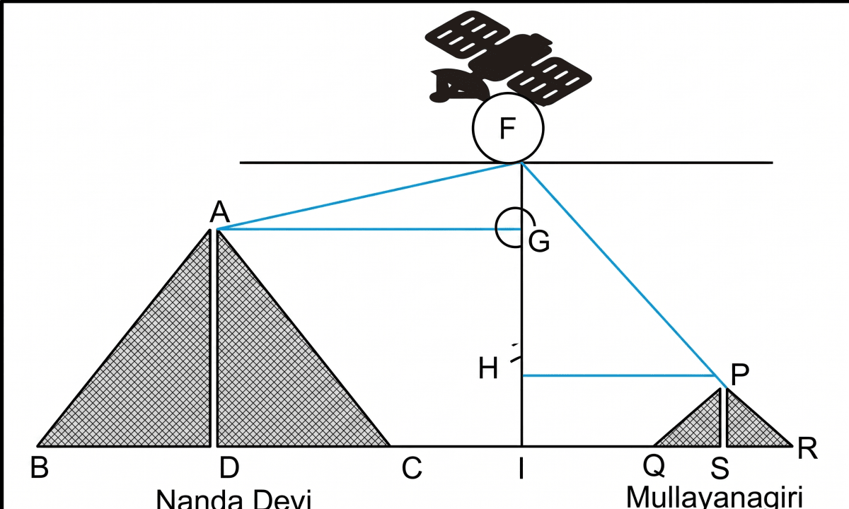
The distance of the satellite from the top of Nanda Devi is :
(a) 577.52 km
(b) 1025.36 km
(c) 1139.4 km
(d) 1937 kmThe distance of the satellite from the top of Mullayanagiri is :
(a) 577.52 km
(b) 1025.36 km
(c) 1139.4 km
(d) 1937 kmThe distance of the satellite from the ground is :
(a) 577.52 km
(b) 1025.36 km
(c) 1139.4 km
(d) 1937 kmWhat is the angle of elevation if a man is standing at a distance of 7816 m from Nanda Devi?
(a) 0°
(b) 30°
(c) 45°
(d) 60°
Answer
As the satellite is vertically above the mid-point of the 1937 km distance between the peaks, the horizontal distance from the satellite to each peak is = 968.5 km.
Thus,
DI = AG = 968.5 km and SI = PH = 968.5 km
(Taking ≈ 1.7, so cos 30° ≈ 0.85.)
1. For Nanda Devi, the angle of depression is 30°.
So, angle of elevation also equals to 30°.
In triangle AFG,
Hence, option (c) is the correct option.
2. For Mullayanagiri, the angle of depression is 60°.
So, angle of elevation also equals to 60°.
In triangle PFH,
Hence, option (d) is the correct option.
3. The vertical drop from the satellite to the top of Nanda Devi is FG.
In triangle AFG,
Adding the height of Nanda Devi (7816 m = 7.816 km), the distance of the satellite from the ground is
Hence, option (a) is the correct option.
4. A man is standing at a distance of 7816 m from Nanda Devi, whose height is 7816 m.
Let θ be the angle of elevation. Then,
Hence, option (c) is the correct option.