
Mahabaleshwar in Maharashtra is one of the wettest place in India due to its location on a
- high altitude
- windward slope
- Tropical Zone
- leeward slope.
Answer
windward slope
Assertion (A): India has a tropical monsoon type of climate.
Reason (R): Its climate is influenced by the monsoon winds which are largely confined to the Tropics.
- Both A and R are true and R is the correct explanation of A.
- Both A and R are true but R does not explain A.
- A is true but R is false.
- A is false but R is true.
Answer
Both A and R are true and R is the correct explanation of A.
Explanation — India has a tropical monsoon type of climate because India lies in the tropical belt and its climate is influenced by the monsoon winds which are largely confined to the Tropics.
The Western Ghats receive more rainfall from the South West monsoon than the Eastern Ghats because
- it lies in the way of South West Monsoon winds.
- it lies in the rain-shadow area of the Himalayas.
- it lies in the rain-shadow area of the Eastern Ghats.
- it is triangular in shape.
Answer
it lies in the way of South West Monsoon winds.
What causes the winter rain along the Coromandel Coast?
- Sea breeze
- Retreating monsoon
- South-west monsoon
- Western disturbances
Answer
Retreating monsoon
Assertion (A): The Himalayas form a climatic barrier separating the Indian subcontinent from the rest of Asia.
Reason (R): They are high mountain ranges with some of the world's highest peaks.
- Both A and R are true and R is the correct explanation of A.
- Both A and R are true but R does not explain A.
- A is true but R is false.
- A is false but R is true.
Answer
Both A and R are true and R is the correct explanation of A.
Explanation — The Himalayas, due to their great height, act as a climatic barrier preventing cold winds from Central Asia, thus influencing the climate of the Indian subcontinent.
Which of the following is NOT a source of rainfall for Punjab and Haryana?
- Western disturbances
- Arabian Sea branch of South-west monsoon
- Bay of Bengal branch of South-west monsoon
- Retreating monsoon.
Answer
Retreating monsoon
Which of the following factors does not affect the climate of a place?
- Varied relief
- The Monsoon Winds
- Distance from the Sea
- Urbanisation
Answer
Urbanisation
Assertion (A): The Western Ghats get heavy rainfall on the western side.
Reason (R): The Western Ghats are parallel to the monsoon winds.
- Both A and R are true and R is the correct explanation of A.
- Both A and R are true but R does not explain A.
- A is true but R is false.
- A is false but R is true.
Answer
A is true but R is false.
Explanation — Western Ghats lie not parallel but perpendicular to the direction of the moist South-West Monsoon winds. These winds go up the slopes of the Western Ghats, become cool and bring heavy rainfall on the western side.
Western disturbances influence the climatic conditions in northern India during which season?
- Summer
- Winter
- Spring
- Monsoon
Answer
Winter
The summer monsoon winds blow in which direction?
- North-East
- South-West
- North-West
- South-East
Answer
South-West
The Arabian Sea Branch of the monsoon winds splits in three. Which of the following is incorrect?
- Western Ghats and Western Coastal Plains.
- Saurashtra Peninsula and Kutch.
- Coast north of Mumbai and the Narmada and Tapi Valleys.
- Coromandel coast and Odisha.
Answer
Coromandel coast and Odisha.
Mahendra was happy that the rains came on time and he could plant his paddy without depending on irrigation. But after a few wet days there was no rain for more than two weeks. What is this period called?
- Burst of monsoon
- Break of monsoon
- Delayed monsoon
- El Nino
Answer
Break of monsoon
Which of the following is good for the cultivation of tea and jute?
- Mango showers
- Loo
- Kalbaisakhi
- None of the above.
Answer
Kalbaisakhi
Where does the Arabian Sea branch join the Bay of Bengal branch?
- In Punjab and Haryana
- In Western Ghats
- In Chota Nagpur Plateau
- In the Sahyadris.
Answer
In Punjab and Haryana
What causes the 'October Heat'?
- High temperature and heavy rainfall.
- Reduced temperature and heavy rainfall.
- High temperature and humidity.
- Reduced temperature and humidity.
Answer
High temperature and humidity
Assertion (A): Nagpur sees a maximum of 45° C in May which drops to 31° C in July.
Reason (R): The rains bring down the temperature.
- Both A and R are true and R is the correct explanation of A.
- Both A and R are true but R does not explain A.
- A is true but R is false.
- A is false but R is true.
Answer
Both A and R are true and R is the correct explanation of A.
Explanation — The monsoon rains begin in June–July, bringing relief from the summer heat and causing a significant drop in temperature in Nagpur.
Why do the interior parts of the Deccan remain dry during the Retreating monsoon?
- Because they lie in the rain-shadow of the Eastern Ghats.
- Because they lie parallel to the Eastern Ghats.
- Because they lie in the rain-shadow of the Western Ghats.
- Because they lie parallel to the Arabian Sea Branch.
Answer
Because they lie in the rainshadow of the Eastern Ghats.
The climate of India is strongly influenced by ............... .
- Trade winds
- Loo
- Easterly winds
- Monsoon winds
Answer
Monsoon winds
Which of the following factors cause the rise in the temperature of mainland of India in the month of March?
- The land breeze blows towards the sea
- The pressure belts shift.
- Southward migration of the Sun from the equator.
- Northward migration of the Sun from the equator.
Answer
Northward migration of the Sun from the equator.
Assertion (A): A large part of the Bay of Bengal Branch of the South West Monsoon is deflected towards the Indian Subcontinent.
Reason (R): The presence of the Arakan Hills along the coast of Myanmar.
- Both A and R are true and R is the correct explanation of A.
- Both A and R are true but R does not explain A.
- A is true but R is false.
- A is false but R is true.
Answer
Both A and R are true and R is the correct explanation of A.
Explanation — Due to the presence of the Arakan Hills along the coast of Myanmar, a large part of the Bay of Bengal Branch of the South West Monsoon is deflected towards the Indian Subcontinent.
The following headline was printed in a newspaper "The monsoon is set to deliver its last bout of rainfall before retreating from the region." In which month would this be published?
- June
- September
- October
- March
Answer
October
Which state in India is the first to experience the onset of the monsoon and the last to see its withdrawal?
- Tamil Nadu
- Kerala
- West Bengal
- Goa
Answer
Kerala
Which of the following areas get rainfall from the Retreating monsoon?
- West Coast of India
- East Coast of India
- Western Ghats
- Thar desert
Answer
East Coast of India
Name the type of climate prevailing over India. Mention any two factors responsible for it.
Answer
India has a tropical monsoon type of climate. Two factors responsible for this type of climate are-
- The Himalayas
- Varied Relief
State two important characteristic features of the Monsoon rainfall in India.
Answer
Two important characteristic features of the Monsoon rainfall in India are-
- Reversal of wind system.
- Uneven distribution of rainfall over the year.
Give a geographical reason for each of the following:
(i) Heatwaves in the end of April are experienced in the northern plains.
(ii) Tropical cyclones are common in the Bay of Bengal as compared to the Arabian Sea.
(iii) The Indo-Gangetic Plain gets some rainfall in the months of December and January.
Answer
(i) The Northern Plains of India experience heatwaves at the end of April due to several geographical reasons. During this time, the Sun starts moving northward, increasing the intensity of solar radiation over the region. The clear skies, dry land surface, and continental type of climate cause rapid heating. In addition, hot, dry winds called Loo blow across the plains, further raising the temperature and leading to heatwave conditions.
(ii) Tropical cyclones are more common in the Bay of Bengal than in the Arabian Sea because the Bay of Bengal is surrounded by land that traps heat. Due to this, the Bay of Bengal has warmer sea surface temperatures, which provide more moisture and energy for cyclone formation.
(iii) The Indo-gangetic plain gets some rainfall in the month of December and January because of the Western Disturbances, which originate in West Asia and in the regions near the Mediterranean sea. These westerly depressions bring winter rainfall over the Indo-Gangetic Plains.
(i) What is 'Monsoon'?
(ii) Name the place in India which receives the heaviest rainfall.
Answer
(i) Monsoon are periodic or seasonal reversing winds. They are divided into two wind systems — the Summer Monsoon that blow south-west and the Winter Monsoon that blow north-east.
(ii) Cherrapunji and Mawsynram in Meghalaya receive the heaviest rainfall.
Mention the different sources of rain in Punjab and Tamil Nadu during the winter season.
Answer
During the winter season, Punjab receives rainfall from temperate cyclones that originate from the Mediterranean Sea. These cyclones are not of great intensity. Tamil Nadu receives rainfall from the north east monsoon winds that blow over the Bay of Bengal and bring winter rainfall to the state.
What is meant by 'rain-shadow area'? Give an example and state the mountains which are responsible for the rain-shadow area.
Answer
A rain shadow area is an area of dry land that lies on the leeward side of a mountain. High mountains act as barriers for cold if they are high enough and lie in the path of rain – bearing winds. The leeward side of the mountains remains dry.
The western ghats in India are an example of mountains causing rain shadow area. The moisture laden winds from the Arabian Sea branch shed most of its moisture on the western slopes of the western ghats due to which by the time they reach the eastern slopes of western ghats the winds have less moisture and this side receives very less rainfall. For example, Mahabaleshwar situated on the Western side of western ghats, receives 250 cm of rainfall whereas Pune, only a few km away, receives less than 70 cm of rainfall.
Study the climatic data given below and answer the questions that follow:
| Month | Jan | Feb | Mar | Apr | May | Jun | Jul | Aug | Sep | Oct | Nov | Dec |
|---|---|---|---|---|---|---|---|---|---|---|---|---|
| Temperature °C | 23.1 | 24.8 | 26.5 | 29.3 | 32 | 32.8 | 33.1 | 32.1 | 30.5 | 29.3 | 28.7 | 26.1 |
| Rainfall cm | 15.3 | 10.1 | 0.3 | 0.1 | 1.3 | 4.5 | 6.1 | 10.2 | 10.5 | 20.1 | 16.8 | 19.0 |
(i) Calculate the annual rainfall experienced by the station.
(ii) What can you conclude about the climate of this station — is it maritime or continental? How did you come to this conclusion?
(iii) Name the season during which rainfall is the heaviest. Name a probable station satisfying this criteria.
Answer
(i) The annual rainfall experienced by the station is 114.3 cm.
(ii) The station experiences Maritime climate. This is because this station experiences moderate climate with not extreme temperature variations between summer and winter.
(iii) The season during which rainfall is the heaviest is retreating monsoon. A probable station that satisfies this criteria is Chennai in Tamil Nadu.
Give a geographical reason for each of the following:
(i) Western Rajasthan receives no rain from the Arabian Sea branch of the South-West Monsoon winds.
(ii) Mangalore is not cold even in the month of December.
(iii) Even in summer Shimla is cooler than Delhi.
Answer
(i) Western Rajasthan receives no rain from the Arabian Sea branch of the South-West Monsoon winds because the Arabian Sea branch of the South west monsoon blows parallel to the Aravali hills. Since the moisture-bearing winds do not strike the mountains, they do not cause any rainfall in Western Rajasthan.
(ii) Mangalore is situated along the Western Coast of India. Therefore, it experiences moderate impact of land breezes and sea breezes all through the year. This keeps the weather of Mangalore moderate i.e. neither too hot nor too cool. Hence, it is not cold even in the month of December.
(iii) Shimla is cooler than Delhi in summer because it is located at a higher altitude than Delhi and the temperature decreases with the height at a rate of 1°C for every 166 m of ascend.
State two points of difference in climate between the northern and the southern zone of India due to latitude.
Answer
Two points of difference in climate between the northern and the southern zone of India due to latitude are —
- The northern zone has cold winter season and hot summer season while the southern zone is warmer than the north but does not have a clear-cut winter season.
- The northern zone doesn't have the mid day sun almost vertically overhead during any part of the year, while the southern zone has the mid day sun almost vertically overhead at least twice a year.
State briefly the impact of water bodies on the climate in coastal areas.
Answer
The water bodies have a great impact on the climate in coastal areas. Water bodies act as a major source of moisture to the summer monsoons and bring heavy rainfall to the whole area. Such areas experience moderate climate, neither too hot nor too cold.
Give a geographical reason for each of the following:
(i) Variations in the type of climate in different regions of India.
(ii) Most parts of India receive rainfall between June and September.
(iii) South-West Monsoon withdraw from northern India in October.
Answer
(i) India has a varied climate due to the presence of various relief features like mountains, deserts, presence of seas etc. Further the large latitudinal extent, altitude, presence of many mountain ranges and nearness to the oceans results in different climatic conditions in different regions.
(ii) Most parts of India receive rainfall between June and September because the differential heating of land and sea during summer season causes the monsoon winds to drift towards the subcontinent.
(iii) South-West Monsoon withdraw from northern India in October because the monsoon trough of low pressure over the Ganga plains becomes weaker due to the apparent southward movement of the sun. The low pressure trough is gradually replaced by high pressure.
(i) What are Jet Streams?
(ii) How do they influence the climate of India?
Answer
(i) Jet streams are cold fast blowing winds that develop in the upper layers of the atmosphere.
(ii) They influence the climate of India as the westerly jet stream prevails over the North Indian Plains during the winter months, while the easterly jet stream steers the tropical depression over India. These depressions play a significant role in the distribution of monsoon rainfall in the subcontinent. The highest rainfall occurs along the track of these depressions.
How does El-Nino affect the climate of India?
Answer
El-Nino increases the surface temperature of the sea and affects the movement of monsoon winds in the Indian Ocean and causes weak drought-like situation in the Indian sub continent.
State two characteristic features of North-East Monsoon.
Answer
Two characteristic features of North-East Monsoon are-
- These winds blow from December to February.
- These winds blow from land to sea.
Mention three important features of rainfall in India.
Answer
Three important features of rainfall in India are-
- There is rainfall over three months and the rest of the year is mostly dry. Seventy percent of annual rainfall occurs in the rainy season.
- The rains are mainly of relief type. The windward slopes of the mountains get more rainfall than the leeward side.
- Only a small portion of the rainfall is received from sources other than the monsoon, like cyclonic rainfall and convectional rainfall.
Give a geographical reason for each of the following:
(i) Pune receives less rainfall than Mumbai.
(ii) Tropical cyclones bring heavy rainfall but temperate cyclones bring light rainfall.
(iii) Kerala has a tropical climate while Bihar has a continental climate.
Answer
(i) Pune receives less rainfall than Mumbai because Mumbai lies on the windward side of the Western Ghats while Pune lies on the leeward side. Since places lying on the leeward side receive less rainfall, Pune receives less rainfall than Mumbai.
(ii) A tropical cyclone is mainly formed due to the development of a low pressure area over the sea, this results in high humidity and temperature which causes heavy rainfall. However, in a temperate cyclone wind speed is low and all sectors of the cyclone have different temperatures which is followed by continuous light rainfall for many days.
(iii) Kerala has a tropical climate while Bihar has a continental climate because Kerala is situated near water bodies while Bihar is situated in the interior of the subcontinent. Influenced by the sea, Kerala experiences maritime climate, neither too hot nor too cold while Bihar experiences continental type of climate, very hot in summer and very cold in winter.
Distinguish between 'Burst of Monsoon' and 'Break of Monsoon'.
Answer
| Burst of Monsoon | Break of Monsoon |
|---|---|
| The sudden violent onset of rainfall in the first week of June is termed as the burst of monsoon. | When the South-west monsoon fails to bring rainfall for two or more weeks and there is a dry period in the rainy season, it is called break of monsoon. |
Define:
(i) Western Disturbances
(ii) Mango Showers
Answer
(i) Western Disturbances — A characteristic feature of the cold weather season is the inflow of depressions from the west and the north-west. These low pressure systems are called western disturbances. They originate in West Asia and the regions near the Mediterranean Sea. They travel eastwards across Iran and Pakistan and reach India during the winter season. They bring the much needed winter rains over the plains and snowfall in the mountains.
(ii) Mango Showers — Mango showers are the pre-monsoon showers in the Indian states of Karnataka, Kerala, Konkan and Goa that help in the ripening of mangoes. These showers are also important for tea and coffee plants.
Give a geographical reason for each of the following:
(i) The monsoon rain is unevenly distributed over India.
(ii) Excessive cold in north India during winter season.
(iii) Most of the India remains dry during the North-East Monsoon season.
Answer
(i) The monsoon rain is unevenly distributed over India because most parts of India receive relief rainfall, therefore windward sides always receive more rainfall than the leeward side. Some places like Aravali and Coromandel coast lie parallel to south west monsoon winds, hence, are not able to obstruct these wind and receive very little rainfall.
(ii) Excessive cold in north India during winter season because north India is far from the sea and the equator. Hence, it experiences continental type of climate — cold winters and hot summers.
(iii) Most of the India remains dry during the North-East Monsoon season because north-east trade winds blow from land to sea and hence, do not carry moisture necessary for rainfall.
(i) Name two regions which get very little rain from the Summer Monsoon.
(ii) Name any two local winds which blow in India during the summer season.
Answer
(i) Tamil Nadu and Rajasthan get very little rain from the Summer Monsoon.
(ii) Two local winds which blow in India during the summer season are Loo and Kalbaisakhi.
What is meant by the season of 'Retreating Monsoon'?
Answer
During the months of October-November, the south-west monsoon winds become weaker and start to retreat from the skies of North India. This phase of the monsoon is known as the retreating monsoon.
Name the months in which Retreating Monsoon rain is experienced.
Answer
Retreating Monsoon rain is experienced in the months of October and November.
Give a geographical reason for each of the following:
(i) The northern plains of India do not freeze in winter.
(ii) In spite of Aravali Range, Rajasthan receives scanty rainfall.
(iii) Chennai has more wet days than Bengaluru.
Answer
(i) The northern plains of India do not freeze in winter because the Himalayas form a climatic barrier separating the Indian subcontinent from the rest of Asia. They prevent the cold Siberian winds from entering India.
(ii) The state of Rajasthan receive scanty rainfall because it lies in the rain-shadow region of the Aravali Mountains. The Aravali Hills run parallel to the Arabian Sea branch, and thus do not form any barrier to intercept the winds. The winds thus passes through Rajasthan without causing any rainfall.
(iii) Chennai is located on the Coromandel Coast (Tamil Nadu) and receives most rainfall from the Northeast Monsoon and the Retreating Monsoon. Bengaluru, located inland in Karnataka, primarily receives rainfall from the Southwest Monsoon. Hence, Chennai has more wet days than Bengaluru.
(i) Name the seasons during which the North-East Trade Winds dominate.
(ii) How do these winds affect the climate of India?
Answer
(i) The North-East Trade Winds dominate during the winter season.
(ii) North-east trade winds blow from land to sea, hence, most parts of the country remain dry. These winds may cause some amount of rainfall on the Coromandel coast. The nights are extremely cold while the days are pleasantly warm.
Give two points of difference between the Arabian Sea branch and the Bay of Bengal branch of South-West Monsoon Winds.
Answer
| Arabian Sea branch of South-West Monsoon Winds | Bay of Bengal branch of South-West Monsoon Winds |
|---|---|
| It enters Indian landmass after blowing over a vast open sea. During this period, it collects a lot of moisture. | It travels a shorter distance and carries less moisture. |
| It hits against the Western Ghats as soon as it blows over the land. | It has to travel a long distance over land before it hits against the mountains. |
Name any two states that receive rain in January-February from North-East Monsoons.
Answer
The eastern coast of Tamil Nadu and Andhra Pradesh receives much rainfall during the winter season through north-east monsoons.
Give a geographical reason for each of the following:
(i) Western part of Rajasthan is a desert region.
(ii) Kochi has a lower annual range of temperature than Agra.
(iii) The Northern plains and Punjab receive winter cyclonic rain in winter.
Answer
(i) The western part of Rajasthan is a desert because the Aravali range lies parallel to the moisture laden winds coming from the Arabian Sea. Since they do not obstruct the winds, it does not rain in western Rajasthan.
(ii) Kochi has a coastal location while Agra is located away from the sea. Due to the influence of the moist winds from the sea, Kochi experiences a moderate climatic condition throughout the year whereas Agra has extreme temperature conditions resulting in high annual range of temperature than Kochi.
(iii) The Northern plains and Punjab receive winter cyclonic rain in winter due to the western disturbances entering the Indian sub-continent from the North-west.
(i) What causes the winter rain along Coromandel coast?
(ii) Name a state which gets sufficient rainfall from the winter monsoon.
Answer
(i) North East Trade winds cause the winter rain along Coromandel coast.
(ii) Tamil Nadu gets sufficient rainfall from the winter monsoon.
Give two points of difference between Tropical Cyclones and Temperate Cyclones.
Answer
| Tropical Cyclones | Temperate Cyclones |
|---|---|
| These are tropical depressions originating in the Bay of Bengal caused by the local variations of heat and moisture. | These low pressure systems originate in West Asia and the regions near the Mediterranean Sea. |
| They are active in November and December. | They are active between December and February. |
An Inter-School Football Match at Visakhapatnam from November 1 to 3 had to be cancelled because of bad weather. Give an explanation for this happening. Your explanation should provide the technical name of this season in India, as well as the pressure conditions over the Bay of Bengal.
Answer
An interschool Football Match at Vishakapatnam from November 1 to 3 had to be cancelled because of the cyclones. This is a season of retreating monsoon. During this season the low pressure conditions of the land are transferred to the centre of the Bay of Bengal that gives rise to cyclonic depressions.
Give a geographical reason for each of the following:
(i) Kanyakumari experiences an equable climate.
(ii) The Coromandel Coast remains dry in July-August.
(iii) Mangalore experiences more rainfall than Mysore.
Answer
(i) Kanyakumari experiences equable climate because it is located near the coast, and there is not much difference between the temperatures during the summer and winter.
(ii) The Coromandel Coast remains dry in July and August because it lies in the rain-shadow region of the Arabian Sea branch of the Southwest monsoon. Also, the Bay of Bengal branch of the monsoon flows almost parallel to the coast, so it does not bring much rain to this region during this time.
(iii) Mangalore lies on the windward side of Western Ghats and Mysore lies on the leeward side of the Western Ghats. Since areas located on the windward side receive more rainfall than the areas located on the leeward side, Mangalore experiences more rainfall than Mysore.
(i) Name one region which gets rainfall from the Retreating Monsoon.
(ii) Name two areas which get more than 200 cm of rainfall in India.
Answer
(i) Tamil Nadu gets rainfall from the Retreating Monsoon.
(ii) Meghalaya and Arunachal Pradesh get more than 200 cm of rainfall in India.
From where does the winter showers in Western Uttar Pradesh and Punjab originate?
Answer
Winter showers in Western Uttar Pradesh and Punjab originate from the weak temperate cyclones from the Mediterranean Sea.
State the economic importance of Kalbaisakhis in West Bengal and Assam.
Answer
Kalbaisakhis are of economic importance in West Bengal and Assam because they bring rainfall in these regions. This rainfall is quite beneficial for growing jute and rice in West Bengal and tea in Assam.
Give a geographical reason for each of the following:
(i) Chennai receives less rain than Thiruvananthapuram although it has more rainy days.
(ii) Shillong gets less than 200 cm of rainfall in a year while Cherrapunji receives more than 1250 cm of rainfall.
(iii) Jaipur has a higher annual range of temperature than Goa.
Answer
(i) Since Thiruvananthapuram lies on windward side of Western ghats therefore it receives heavy rainfall from South West monsoon while Chennai lies on the leeward side and gets rainfall from North East monsoon which is not as strong. Thiruvananthapuram also gets some rain from the retreating Monsoon.
(ii) Cherrapunji lies on the crest of the southern range of Khasi hills. It receives rain from the South West Monsoon Bay of Bengal Branch as it is in the pathway of these winds. Hence, it receives heavy rainfall. Shillong is located on the upper (leeward) side of the Garo-Khasi-Jaintia hills, which is a rain shadow area and hence, receives less than 200 cm of rainfall in a year.
(iii) Jaipur has a higher annual range of temperature than Goa because Jaipur is situated in the northern part of India, away from the sea. Hence, Jaipur experiences continental type of climate, too hot in summer and too cold in winter. Goa, on the other hand, is situated near the sea so it has a moderate type of climate, neither too hot nor too cold.
Briefly explain the role of the Himalayas in determining the climate of India during:
(i) the hot weather season
(ii) the southwest monsoon season
Answer
(i) The Himalayas form a climatic barrier separating the Indian subcontinent from the rest of Asia. They prevent the cold Siberian winds from entering the Indian region and from India becoming a cold desert.
(ii) During the South West Monsoon season, the Himalayas play an important role in determining the amount of rainfall received by several places in the country. They act as a barrier to the South West Monsoon winds coming from the Indian Ocean. These winds when strike the mountains bring rainfall to the northern plains.
According to a news report the onset of southwest monsoon over Kerala was delayed and happened on June 8, 2023 due to El Nino. What is El Nino? What is the expected date for the onset of Southwest Monsoons over Kerala?
Answer
El-Nino refers to an abnormal warming of surface waters in the equatorial Pacific region. It increases the surface temperature of the sea and affects the movement of monsoon winds in the Indian Ocean.
The expected date for the onset of Southwest Monsoons over Kerala is June 1.
Uneven monsoon with below average rainfall in June, above average rainfall in July and a dry August was reported one year. How does this pattern of rainfall differ from the regular pattern of rainfall over the subcontinent.
Answer
This pattern of rainfall is different from the regular monsoon pattern in India. Normally, the Southwest monsoon sets in by early June and brings steady rainfall through June to September. Rainfall is usually well-distributed during these months.
However, in the year mentioned, rainfall was below average in June, unusually high in July, and almost dry in August. This uneven distribution can affect agriculture and water availability, as crops need regular and timely rain.
The difference is highlighted in the table below:
| Month | Normal Monsoon Pattern | Observed Pattern (One Year) |
|---|---|---|
| June | Steady onset with moderate rainfall | Below average rainfall |
| July | Heavy and consistent rainfall | Above average rainfall |
| August | Continued rainfall, slightly reduced | Very little or no rainfall (dry month) |
Give a geographical reason for each of the following:
(i) The northern hills of Assam do not get as much rainfall as the southern hills.
(ii) Northern India has cold-wave conditions in January.
(iii) The month of October is marked by sultry humid weather.
Answer
(i) The southern hills of Assam lie directly in the path of moisture-laden winds of Bay of Bengal branch of the South-west Monsoon. Hence, most of their moisture is shed over the southern hills and these winds become drier as they move northward. This creates a rain-shadow effect, leading to less rainfall in the northern hills of Assam.
(ii) Northern India has cold-wave conditions in January due to cold, dry northeast monsoon winds. A high-pressure area forms over Central Asia and northwest India, while a low-pressure area lies over the Indian Ocean. Winds blowing from land to sea bring cold, dry weather, and cold winds from the Caspian Sea and Turkmenistan lower temperatures further.
(iii) The month of October is marked by sultry and humid weather because the Southwest monsoon begins to retreat from northern India. Although the skies start to clear and night temperatures drop, the land remains moist after the rains. The combination of high day temperatures and moisture in the air give rise to sultry humid weather in October.
Study the climatic data for cities A and B given below and answer the questions that follow:
City A
| Month | Jan | Feb | Mar | Apr | May | Jun | Jul | Aug | Sep | Oct | Nov | Dec |
|---|---|---|---|---|---|---|---|---|---|---|---|---|
| Temperature °C | 15.4 | 19.5 | 24.9 | 29.6 | 31.5 | 31.7 | 30 | 29.8 | 29.2 | 27.1 | 22.3 | 17.2 |
| Rainfall mm | 11 | 14 | 10 | 13 | 45 | 165 | 355 | 280 | 200 | 50 | 7 | 6 |
City B
| Month | Jan | Feb | Mar | Apr | May | Jun | Jul | Aug | Sep | Oct | Nov | Dec |
|---|---|---|---|---|---|---|---|---|---|---|---|---|
| Temperature °C | 24 | 26 | 29 | 30.8 | 32 | 31.6 | 30 | 29.6 | 29.6 | 28.6 | 26.4 | 24.2 |
| Rainfall mm | 10 | 12 | 11 | 20 | 65 | 120 | 130 | 160 | 200 | 210 | 90 | 8 |
(i) Calculate the annual rainfall for both cities.
(ii) Where are the two cities located? Give reasons to support your answer.
Answer
(i) City A annual rainfall = 1156 mm
City B annual rainfall = 1036 mm
(ii)
City A
Upon analyzing the temperature and rainfall patterns of City A, Delhi closely matches the provided data.
Reasons:
- The climatic data of city A indicates a region with a continental climate, characterized by cool winters, warm summers, and a pronounced monsoon season with significant rainfall during the summer months.
- Heavy rainfall experienced from the South west monsoon, with peaks in July-September.
- Almost no rainfall from November to April.
City B
Upon analyzing the temperature and rainfall patterns of City B, Bengaluru (Bangalore) in Karnataka closely matches the provided data.
Reasons:
- This city experiences moderate temperatures throughout the year with no extreme cold, indicating a Maritime climate.
- Due to South-west monsoon, the rainfall increases from June, peaking between July and October, and tapering off by November.
Taru has lived in Pune for her entire life. Now she has to shift to Ludhiana. As a student of geography what would you tell her to prepare her for life in the new city?
Answers
Utilising my knowledge of geography, I would tell Taru that Ludhiana has a very different climate compared to Pune.
- Pune has a moderate climate due to its location on the Deccan Plateau, but Ludhiana experiences continental climate. So Taru should expect very hot summers, very cold winters, and moderate monsoon rainfall.
- Taru should be prepared for high temperatures in summer, often going above 40°C.
- Taru will notice less frequent and less intense rainfall in Ludhiana compared to Pune. While Pune faces heavy rainfall due to Southwest monsoon, Ludhiana has moderate rainfall (~700mm annually), but unevenly distributed. It mainly gets rain from the Southwest Monsoon and some showers from Western Disturbances in winter.
- Unlike Pune's mild winters, with temperatures rarely falling below 10°C, Ludhiana has severe cold winters, with temperatures dropping as low as 5°C or below, along with foggy conditions. So, Taru must be prepared for much colder winters and may need heavy woollen clothing.
Explain why the South West Monsoon winds enter West Bengal from the south or south-east direction.
Answer
The Bay of Bengal branch of the South-west monsoon is directed towards the coast of Myanmar and part of south-east Bangladesh. However, owing to the presence of the Arakan Hills along the coast of Myanmar, a large part of this branch of monsoon is deflected towards the Indian subcontinent. The monsoons, therefore, enter West Bengal from south and south-east instead of the south-westerly direction.
How would the monsoon mechanism be affected by the absence of the Great Indian Desert?
Answer
The Great Indian Desert (Thar Desert) plays a vital role in the monsoon mechanism by heating up during summer and creating a strong low-pressure area that attracts moisture-laden southwest monsoon winds. Without it, this low pressure would be weaker, reducing monsoon rainfall in northern and northwestern India. The Thar Desert also cools quickly after summer, helping in the early withdrawal of monsoons by reversing wind patterns. Its absence could lead to irregular monsoon withdrawal and weaker rainfall, affecting agriculture and the overall climate of the region.
Most parts of India do not receive rainfall in the winter season. Why? Name two regions that receive winter rainfall and identify each region's source.
Answer
Most parts of India do not receive rainfall in the winter season because during this time, the winds blow from the land to the sea (northeast monsoon winds). Since these winds originate over the land and have anti-cyclonic circulation, they are dry and do not carry much moisture. As a result, they do not cause significant rainfall in most parts of the country.
Two regions that receive winter rainfall are:
- Punjab — Punjab receives rainfall from Western Disturbances (temperate cyclones) that originate from the Mediterranean Sea.
- Tamil Nadu — Tamil Nadu receives rainfall from the North East Monsoon Winds. These winds pick up moisture while blowing over the Bay of Bengal and bring rainfall to Tamil Nadu.
The IMD collates rainfall between June and September as SW monsoon. Answer the following question.
The southwest monsoon typically accounts for about 70% of India's annual rainfall, making it vital for the country's agrarian economy, which contributes approximately 14% to the national GDP. A good monsoon would boost the economy, how?
Answer
India's economy is primarily agriculture based. A good Southwest Monsoon significantly impacts India's economy by enhancing agricultural productivity in following ways:
- A good southwest monsoon brings enough rainfall for healthy crop growth.
- It improves agricultural output, which benefits farmers.
- Increased rural income boosts demand for goods and services.
- Food prices stay stable or fall, reducing inflation.
- Industries linked to farming, like food processing, also grow.
- Contributing 14% to the national GDP, agriculture supports millions and good monsoon boosts agriculture which in turn improves the overall economy.
The IMD collates rainfall between June and September as SW monsoon. Answer the following question.
By 30 September, 2024 regions like Rajasthan, Gujarat, Tamil Nadu, and Goa have recorded extraordinary surpluses, with Rajasthan alone seeing a 57% increase over average rainfall, Would the surplus rainfall be beneficial? How?
Answer
The surplus rainfall in regions like Rajasthan, Gujarat, Tamil Nadu, and Goa can have both positive and negative geographical impacts:
Benefits of Surplus Rainfall
Groundwater Recharge – In arid and semi-arid regions like Rajasthan and Gujarat, excessive rainfall helps recharge groundwater tables and fills reservoirs, reducing water scarcity.
Agricultural Productivity – Increased rainfall enhances soil moisture, benefiting rain-fed crops like millets, pulses, and cotton in Gujarat and Rajasthan.
Reservoir and River Replenishment – In Tamil Nadu and Goa, monsoon-fed rivers like the Cauvery and Mandovi receive more water, supporting irrigation and drinking water supply.
Hydropower Generation – Dams such as the Sardar Sarovar Dam in Gujarat and Mettur Dam in Tamil Nadu can store surplus rainwater, increasing hydropower production.
Challenges of Surplus Rainfall
Flooding and Waterlogging – Rajasthan and Gujarat, with their low drainage capacity, can experience flash floods, affecting settlements and infrastructure.
Soil Erosion and Landslides – In Goa and Tamil Nadu, heavy rainfall can trigger coastal erosion and landslides, particularly in hilly areas like the Western Ghats.
Crop Damage – Excessive rainfall can lead to waterlogging in paddy fields in Tamil Nadu and spoil harvested crops.
Thus, while surplus rainfall enhances water availability, its impact varies based on topography, land use, and drainage systems in each region.
The IMD collates rainfall between June and September as SW monsoon. Answer the following question.
There have been regional imbalances in the rainfall received with several states having deficits: Manipur (-30%), Bihar (-26%), Punjab (-23%), and Himachal Pradesh (-21%). While the surplus is beneficial for India's overall water availability and agricultural output, states experiencing deficits may continue to face difficulties. With the help of an example explain what difficulties would these states face.
Answer
Regions experiencing a rainfall deficit face severe geographical challenges due to reduced water availability, agricultural distress, and ecological imbalances.
Example: Bihar (-26% Rainfall Deficit)
Impact on Agriculture: Bihar relies heavily on the Southwest Monsoon for its kharif crop cultivation, particularly paddy (rice). A 26% deficit means lower soil moisture, affecting sowing, crop growth, and yields.
Reduced Groundwater Recharge: Lower monsoon rainfall leads to less infiltration into aquifers, worsening water scarcity in districts dependent on wells and tubewells for irrigation.
Drought-Like Conditions: Parts of south and central Bihar, which already receive less rainfall compared to the flood-prone north, may experience drought-like conditions, impacting food security.
Thus, states facing monsoon deficits experience agricultural setbacks, water shortages, and ecological imbalances, requiring efficient water management strategies to mitigate long-term impacts.
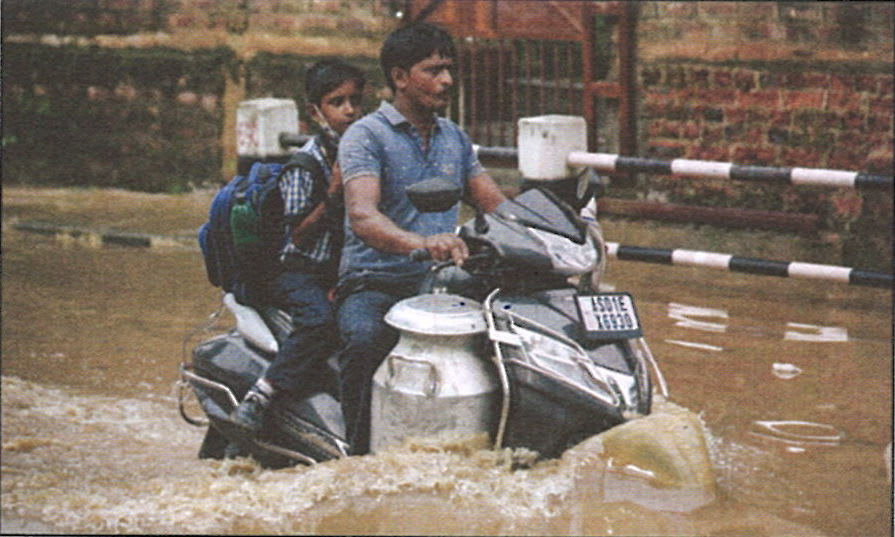
Study the picture on the right. Briefly explain what could be the cause of this calamity and what could be done to bring relief.
Answer
The image depicts urban flooding, where a man is navigating a waterlogged road.
Causes of the Calamity:
- Heavy Rainfall Due to Monsoon: Intense rainfall, especially during the Southwest Monsoon (June-September), can overwhelm drainage systems, leading to water stagnation on roads.
- Poor Drainage and Urbanization: Encroachment of natural drainage channels, excessive concretization, and lack of proper stormwater drainage result in inefficient water runoff.
- Low-Lying Area and Poor City Planning: Some cities are located in low-lying flood-prone areas, where water accumulates easily, causing flooding.
- Clogging of Drains: Accumulation of garbage and plastic waste in drains prevents water from flowing, worsening waterlogging conditions.
Measures to Bring Relief:
- Improving Drainage Systems: Cleaning and maintaining storm water drains to ensure smooth water flow and constructing underground drainage systems in flood-prone urban areas.
- Sustainable Urban Planning: Developing permeable surfaces like parks and green belts to allow water absorption, and preventing illegal construction that blocks drainage pathways.
- Early Warning Systems: Implementing weather forecasting and flood alert systems to prepare in advance.
- Public Awareness and Waste Management: Educating citizens about responsible waste disposal to prevent drain blockages.
By addressing urban planning, waste management, and drainage efficiency, cities can reduce flooding and minimize disruptions caused by heavy rainfall.
On my visit to the queen of the hills, the city of Nainital in the month of December, there was snowfall and I stayed indoors. I was thrilled but also amazed as to why it occurred when it was cold winters.
(i) What is the cause for the precipitation to occur at Nainital?
(ii) Explain the phenomenon which leads to the given situation.
Answer
(i) Western Disturbances are the cause for the precipitation to occur at Nainital.
(ii) During winter, western disturbances bring moist winds to northern India. In high-altitude regions like Nainital, low temperatures cause this moisture to condense and fall as snow instead of rain.
At Lucknow, during the month of May, the hot dry season is characterized by a local wind, which increases the temperature for the city and keeps all the people mostly indoors during the afternoon.
(i) What type of local wind is discussed?
(ii) How is it responsible for the given climatic condition prevailing in the above-mentioned City?
Answer
(i) The local wind being discussed is called 'Loo'.
(ii) The Loo is a hot, dry local wind that blows over northern India in May. It raises temperatures in Lucknow to over 45°C, causing extreme heat. This makes afternoons unbearable, forcing people to stay indoors to avoid heat-related illnesses.