
The unit of measuring rainfall is
- Celsius.
- centimetres.
- metres.
- bar.
Answer
centimetres.
Reason — Rainwater collected in a rain gauge is poured into a measuring jar that is graduated in millimetres and centimetres, so rainfall is measured in centimetres. Celsius is the unit of temperature and bar (millibar) is the unit of atmospheric pressure, while metres is not used to express the depth of rainfall.
Isohyets are lines joining places
- getting same amount of rainfall.
- having equal pressure.
- with equal temperature.
- experiencing equal wind speeds.
Answer
getting same amount of rainfall.
Reason — Isohyets are imaginary lines joining places that receive the same amount of rainfall over a unit of time. Lines joining places having equal temperature are isotherms, not isohyets, and isohyets do not join places of equal pressure or equal wind speed.
Which of the following statements are correct about the pressure condition?
A. High pressure areas are associated with calm weather conditions.
B. Pressure is measured by anemometer.
C. Low pressure areas are associated with unsettled and stormy weather conditions.
D. Pressure increases with altitude of a place.
Which of the following options is correct?
- A and B are correct.
- B and C are correct.
- A and C are correct.
- B and D are correct.
Answer
A and C are correct.
Reason — High-pressure zones are associated with calm and fair weather as the cooler air sinks and gets compressed, while low-pressure areas are associated with unsettled and stormy weather, so A and C are correct. B is wrong because pressure is measured by a barometer, not an anemometer (which measures wind speed), and D is wrong because pressure decreases, not increases, with altitude as the air becomes thinner or less dense.
Which of the following are correctly matched?
| Elements of Climate | Features |
|---|---|
| A. Temperature | 1. It decreases with a decrease in altitude. |
| B. Humidity | 2. It increases in summer and not in winter. |
| C. Precipitation | 3. It is more on the leeward side of the mountains. |
| D. Wind | 4. It is offshore during summers. |
Which option is correct?
- A. and 1. are correct
- B. and 2. are correct
- C. and 3. are correct
- D. and 4. are correct.
Answer
B. and 2. are correct
Reason — Higher humidity is experienced during summer as warm air expands and can hold more moisture, so B–2 is correctly matched. A is wrong because temperature decreases with an increase in altitude (the higher the altitude, the lower the temperature); C is wrong because precipitation is greater on the windward side, the leeward side lying in the rain shadow; and D is wrong because winds blow onshore, not offshore, during summers.
Which of the following cities experience a moderate or milder climate?
- Delhi
- Chandigarh
- Mumbai
- Jaipur
Answer
Mumbai
Reason — Mumbai lies close to the sea, so it enjoys an equable temperature and experiences a moderate or milder climate. Delhi, Chandigarh and Jaipur lie away from the sea and therefore experience extremes of temperature.
Wet air exerts ................. pressure than dry air.
- more
- no
- less
- equal
Answer
less
Reason — Wet air is lighter than dry air and therefore exerts less pressure than dry air. It cannot exert more, no or equal pressure compared to dry air.
Which of the following types of wind will bring rainfall to a place?
- warm winds
- cold winds
- moderate winds
- moist winds
Answer
moist winds
Reason — Moist winds carry water vapour and therefore can bring rainfall to a place. For example, winds blowing from seas or oceans bring rainfall.
If a given volume of air holds 25 g of water vapour at a given temperature when its actual capacity is 50 g, what would be its relative humidity?
- 50%
- 60%
- 70%
- 80%
Answer
50%
Reason — Relative humidity is the ratio of the actual amount of water vapour present in a given volume of air to the maximum amount it can hold at that temperature, expressed as a percentage. Here it is (25 ÷ 50) × 100 = 50%, which means the air is holding only 50 per cent of its actual capacity.
Rainfall is caused when a physical barrier such as a mountain forces moisture-bearing winds to cause rain. Identify the type of rainfall.
- convectional rainfall
- orographic rainfall
- cyclonic rainfall
- frontal rainfall
Answer
orographic rainfall
Reason — Orographic rainfall is caused when a physical barrier such as a mountain forces moisture-bearing winds to rise and cause rain. Convectional rainfall occurs when heated air rises, expands and cools, and cyclonic rainfall occurs when warm and cold air meet; frontal rainfall is not among the three types of rainfall described.
Which of the following types of clouds are the most common forms of high-level clouds?
- cumulus clouds
- stratus clouds
- cirrus clouds
- nimbus clouds
Answer
cirrus clouds
Reason — Cirrus clouds are the most common form of high-level clouds; they are thin and wispy and are known as 'mare's tails'. Cumulus and stratus clouds are low-level clouds, and nimbus clouds are dark rain clouds, so none of these are high-level clouds.
This is an easily portable instrument used for measuring air pressure that resembles a pocket watch. Identify this instrument.
- an aneroid barometer
- a thermometer
- a hygrometer
- an anemometer
Answer
an aneroid barometer
Reason — An aneroid barometer is an easily portable instrument used for measuring air pressure; it resembles a small pocket watch and contains no liquid. A thermometer measures temperature, a hygrometer measures humidity, and an anemometer measures wind speed.
What do isotherms join on a map?
- places having equal rainfall
- places having equal air pressure
- places having equal temperature
- places having equal wind speed
Answer
places having equal temperature
Reason — Isotherms are lines joining places having equal temperature, and isothermal maps show the distribution of temperature over an area. Lines joining places of equal rainfall are isohyets, and isotherms do not join places of equal air pressure or equal wind speed.
Assertion (A): Weather forecast is the prediction of weather conditions.
Reason (R): Weather forecasts help in ocean navigation and fishing.
- Both (A) and (R) are true but (R) is not the correct explanation for (A).
- Both (A) and (R) are true and (R) is the correct explanation of (A).
- (R) is true but (A) is false.
- (A) is true but (R) is false.
Answer
Both (A) and (R) are true but (R) is not the correct explanation for (A).
Explanation — Weather forecast is indeed the prediction of weather conditions issued by the meteorological departments, so A is true. It is also true that weather forecasts help in ocean navigation and fishing, so R is true. However, R states a use or benefit of weather forecasting, whereas A defines what a weather forecast is; a use of forecasting does not explain its definition. Hence R is not the correct explanation of A.
Assertion (A): All weather changes take place in the lowest layer of the atmosphere.
Reason (R): Weather changes over a short period of time.
- A is true, but R is false.
- A is false, but R is true.
- Both A and R are true, but R is not the correct explanation of A.
- Both A and R are true, and R is the correct explanation of A.
Answer
Both A and R are true, but R is not the correct explanation of A.
Explanation — All weather changes do take place in the troposphere, the lowest layer of the atmosphere, so A is true. Weather also changes over a short period of time, so R is true. However, R describes the short duration over which weather changes, while A states the layer in which they occur; the duration does not explain why the changes take place in the lowest layer. Hence R is not the correct explanation of A.
Assertion (A): Pressure is closely related to the temperature of a place.
Reason (R): The molecule of air thus becomes less dense and exerts less pressure.
- A is true, but R is false.
- A is false, but R is true.
- Both A and R are true, but R is not the correct explanation of A.
- Both A and R are true, and R is the correct explanation of A.
Answer
Both A and R are true, and R is the correct explanation of A.
Explanation — Pressure is closely related to the temperature of a place, so A is true. When the temperature rises, the air expands and rises up, becoming less dense and exerting less pressure, so R is true. R explains exactly how temperature influences pressure — a rise in temperature makes the air less dense, thereby lowering the pressure. Hence R is the correct explanation of A.
Assertion (A): Isotherms are lines joining places having equal temperature.
Reason (R): Isothermal maps show the distribution of temperature over an area.
- A is true, but R is false.
- A is false, but R is true.
- Both A and R are true, but R is not the correct explanation of A.
- Both A and R are true, and R is the correct explanation of A.
Answer
Both A and R are true, but R is not the correct explanation of A.
Explanation — Isotherms are indeed lines joining places having equal temperature, so A is true. Isothermal maps do show the distribution of temperature over an area, so R is true. However, R describes what an isothermal map shows, while A defines what an isotherm is; the function of the map does not explain the definition of the line. Hence R is not the correct explanation of A.
Give reason — Deserts have very hot days and equally cold nights.
Answer
Hot deserts have an absence of cloud cover. Clouds reduce the amount of insolation during the day and also trap terrestrial radiation at night, thus preventing extremes of temperature. Since deserts lack cloud cover, the Sun's heat reaches the ground unhindered making the days very hot, while at night the heat escapes freely making the nights very cold. This is why deserts have very hot days and equally cold nights.
Give reason — Winter in Delhi is severe while in Chennai it cannot be felt.
Answer
Chennai lies close to the sea, so it enjoys an equable (moderate) temperature throughout the year and its winters are mild. Delhi lies far away from the sea, so it experiences extremes of temperature and therefore has severe winters. This is why winter in Delhi is severe while in Chennai it can hardly be felt.
Give reason — Atmospheric pressure influences movement of wind.
Answer
Wind is moving air that is guided by the distribution of atmospheric pressure. Wind always tends to blow from a region of high pressure to a region of low pressure. The velocity of the wind also depends on the difference in pressure — high-speed winds blow when there is a large difference in pressure, while the speed is less when the difference in pressure is less. Thus, atmospheric pressure influences the movement of wind.
Give reason — Winds deflect from their original path in both hemispheres.
Answer
Winds deflect from their original path because of the Coriolis force, which develops due to the rotation of the Earth. Due to this force, winds deflect to the right of their path in the northern hemisphere and to the left of their path in the southern hemisphere.
Give reason — The climate is more stable and permanent in nature.
Answer
Climate represents the average weather conditions of a place over a long period of time. Short-term changes in weather are therefore averaged out, so climate does not change quickly like weather and is more stable and permanent in nature.
Give reason — Winds modify the weather of a place considerably.
Answer
Winds modify the weather of a place considerably because warm winds make places warmer, while cold winds decrease the temperature of a place. Moist winds, such as those blowing from over the sea or ocean, bring rainfall to a place. In these ways, winds considerably modify the weather of a place.
Give reason — Weather forecast by the meteorological station is very important.
Answer
Weather forecast by meteorological stations is important because it guides ocean navigation, fishing, cropping patterns and aviation schedules. It helps farmers and air traffic authorities prepare for weather changes and is also useful for military operations, geographical expeditions and sports events. It further helps reduce damage likely to be caused by climatic disasters such as hurricanes and cyclones.
Give reason — The rain gauge is placed below the ground, only 30 cm of it remains above the ground.
Answer
The rain gauge is placed below the ground such that only 30 cm of it remains above the ground. This prevents splashing and evaporation of the water collected in the jar and helps ensure an accurate measurement of rainfall.
Give reason — Wind vanes are placed in open areas.
Answer
A wind vane is a simple instrument used to determine the direction of the wind. It is placed in open areas where the wind is not blocked by buildings or trees, so that it can move freely and point accurately to the direction from which the wind is blowing.
Define the following terms:
a. loo
b. humidity
c. dew
d. aneroid barometer
e. isohyets
Answer
a. Loo — The loo is a hot, dry, summer afternoon wind that blows from the deserts of Rajasthan over the western Ganga Plain and causes a severe heatwave as it drastically increases the temperature.
b. Humidity — Humidity is the amount of moisture content in the air.
c. Dew — Dew refers to small drops of water that form on the ground during the night due to the condensation of water vapour from the air on the surfaces of objects exposed to the sky, such as grass and plants.
d. Aneroid barometer — An aneroid barometer is an easily portable instrument used for measuring air pressure. It resembles a small pocket watch and does not contain any liquid; it is used by explorers and travellers.
e. Isohyets — Isohyets are imaginary lines joining places with the same amount of rainfall over a unit of time. They are drawn at uniform intervals on maps.
The instrument that measures wind speed.
Answer
Anemometer
The instrument that measures humidity in the air.
Answer
Hygrometer
The scientific study of weather conditions.
Answer
Meteorology
The wooden shelter in which thermometers are kept in a weather station.
Answer
Stevenson's screen
The difference between the maximum and minimum temperatures in a day.
Answer
Diurnal range of temperature
Explain how the following affect the temperature of the place:
i. Latitudinal position
ii. Altitude
iii. Distance from the sea
iv. Ocean current
v. Wind
Answer
i. Latitudinal position — Lower latitudes closer to the Equator are generally warmer than the higher latitudes closer to the Poles. This is why we wear warm woollens in London and light cottons in Singapore.
ii. Altitude — The higher the altitude, the lower the temperature. This explains why hill stations are cooler than the plains.
iii. Distance from the sea — Places close to the sea enjoy an equable temperature, while those away from the sea experience extremes of temperature. This is why cities such as Mumbai, Chennai and Goa experience a moderate or milder climate unlike Delhi, Jaipur and Chandigarh.
iv. Ocean current — Warm ocean currents increase the temperature of coastal areas, while cold currents decrease the temperature. For example, the north-eastern coast of Canada remains frozen during the long winter due to the cold Labrador Current, while the Norwegian Coast on the same latitude remains ice-free during winter due to the warm North Atlantic Drift.
v. Wind — Winds blowing from colder regions lower the temperature, while those from warmer regions raise the temperature. For example, the loo, a hot, dry, summer wind from the deserts of Rajasthan, causes a severe heatwave as it drastically increases the temperature.
Name the factors that influence atmospheric pressure. Explain in brief.
Answer
Atmospheric pressure depends on factors such as altitude, temperature, moisture content and rotation of the Earth.
- Altitude — As we reach higher altitudes, pressure drops as the air becomes thinner or less dense.
- Temperature — If temperature rises, the air expands and rises. The air becomes less dense and exerts less pressure. Regions with lower temperature have denser air, which sinks to create high-pressure zones.
- Moisture content — Wet air exerts less pressure than dry air.
- Rotation of the Earth — The rotation of the Earth deflects winds and either causes them to pile up to form high-pressure zones (subtropical high pressure zone) or scatters them to form low-pressure zones (subpolar low pressure zone).
State the conditions when the humidity is higher in the air.
Answer
Humidity is higher in the air under the following conditions:
- Warm air holds more moisture than cold air, so humidity is higher in the lower latitudes, where the air is warmer than in the higher latitudes.
- Humidity is higher in coastal areas than in the continental interior locations.
- Higher humidity is experienced during summer as warm air expands and can hold more moisture.
How does rainfall occur?
Answer
Rainfall occurs due to the condensation of water vapour into tiny droplets of water. These droplets coalesce to form larger droplets and clouds. When the clouds become too heavy, the water cannot remain suspended in the air and comes down as rain. Rain is the most common form of precipitation.
How are clouds formed? Name the four main types of clouds and explain their characteristics in brief.
Answer
When warm air rises, it expands and cools. Cold air can hold less moisture than warm air, so the air soon becomes saturated. When the dew point is reached, further cooling causes water vapour to condense around small particles of dust called condensation nuclei. These minute water droplets gather together to form clouds.
The four main types of clouds are:
- Cirrus clouds — Cirrus clouds are the most common form of high-level clouds. They are thin and often wispy and are commonly known as 'mare's tails' as they are shaped like the tail of a horse. They are generally seen during fair weather.
- Cumulus clouds — Cumulus clouds are low-level clouds. They are fluffy and often look like the head of a cauliflower. Generally, they occur in fair weather conditions, but they may bring precipitation when they grow into big grey clouds.
- Stratus clouds — Stratus clouds are low-level clouds characterised by horizontal layering and a fairly uniform grey or white colour. When thick enough, they produce drizzle or a small amount of snowfall.
- Nimbus clouds — Nimbus clouds are dark rain clouds. They often combine with cumulus to form cumulonimbus clouds, the 'thunderhead' that brings storm, hail and tornadoes, and other forms of precipitation.
What is weather forecast? What is its significance?
Answer
Weather forecast is the prediction of weather conditions issued by the meteorological departments of a country on the basis of the data collected using various instruments and, more importantly, from images sent by artificial satellites set up in orbit around the Earth.
Significance of weather forecast:
- It guides ocean navigation, fishing activity in the open sea, cropping patterns and aviation schedules.
- Conditions of weather such as wind direction, velocity and cloud cover guide air traffic.
- Temperature, humidity and precipitation control the cropping pattern and season of a place, so a weather report helps farmers prepare for any changes in weather conditions.
- Military operations, geographical expeditions and important sports events all take weather forecasts into consideration.
- It helps to reduce the damage likely to be caused by natural climatic disasters such as hurricanes and cyclones.
Name the two scales in which temperature is measured. State the boiling point and freezing point of water in each of the scales.
Answer
Temperature is measured in two scales — the Fahrenheit scale and the Celsius scale.
- In the Fahrenheit scale, the freezing point of water is 32°F and the boiling point is 212°F.
- In the Celsius scale, the freezing point of water is 0°C and the boiling point is 100°C.
Explain how the maximum and minimum temperatures of a day are measured?
Answer
The maximum and minimum temperatures of a day are measured using Six's maximum and minimum thermometer, a U-shaped thermometer filled with mercury and alcohol.
The maximum temperature is recorded between 1 pm and 3 pm. When there is a rise in temperature, the mercury in the maximum thermometer (tube R) expands and pushes the metal index above it in an upward direction, recording the highest temperature. The index remains fixed on its springs even when the mercury level drops.
The drop in the mercury level in tube R causes the mercury level in the minimum thermometer (tube Q) to rise, moving the metal index upwards. This records the minimum temperature. The minimum temperature is recorded between 4 am and 6 am.
After the two readings are noted down, the instrument is set for the next day by moving the metal indices with a magnet to touch the mercury surfaces in tubes Q and R. The instrument is kept in a Stevenson's screen so that the correct shade temperatures are obtained without the influence of direct heat and precipitation.
Look at the given picture and answer the following questions.
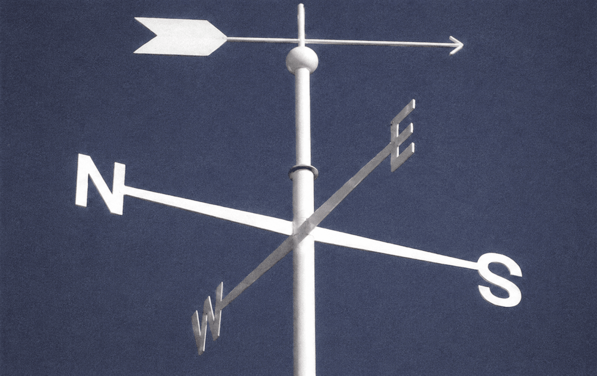
a. Name the equipment seen in the picture.
b. What is its use?
c. Where is it placed?
d. How many parts does it have? How do they work?
Answer
a. The equipment seen in the picture is a wind vane.
b. A wind vane is a simple instrument used to determine the direction of the wind.
c. It is placed in open areas where the wind is not blocked by buildings or trees.
d. A wind vane consists of two parts:
- A pointer mounted on a pole that moves freely and points to the direction from which the wind is blowing.
- A fixed marker, showing the cardinal directions — north, south, east and west — which helps to determine the direction of the wind.
Winds are named after the direction from which they blow. For example, winds blowing from the west are called westerly winds.
Look at the given picture and answer the following questions.
a. Name the equipment seen in the picture.
b. What is it used for?
Answer
a. The equipment seen in the picture is a windsock (also called a wind cone).
b. A windsock is used to indicate the direction of the wind and to give a rough idea of the wind speed. It points in the direction towards which the wind is blowing, and the more horizontal it stretches out, the stronger the wind.
Data Interpretation Question. From the given table, answer the following questions.
| Months | J | F | M | A | M | J | J | A | S | O | N | D |
|---|---|---|---|---|---|---|---|---|---|---|---|---|
| Temp. (°C) | 21.7 | 23.3 | 27.9 | 31.7 | 33.9 | 33 | 29.8 | 28.5 | 29 | 29.4 | 26.2 | 22.7 |
| Rainfall (in cms) | 3.0 | 3.5 | 5.0 | 0.05 | — | — | 1.0 | 4 | 3 | 2 | 2.5 | 3 |
a. Which month has the highest temperature?
b. Which month has the highest rainfall?
c. Calculate the annual rainfall.
d. Find out the average temperature of the summer months—April, May and June.
e. What is the annual range of temperature?
Answer
a. May has the highest temperature, at 33.9°C.
b. March has the highest rainfall, at 5.0 cm.
c. Annual rainfall = 3.0 + 3.5 + 5.0 + 0.05 + 0 + 0 + 1.0 + 4 + 3 + 2 + 2.5 + 3 = 27.05 cm.
d. Average temperature of the summer months (April, May and June) = (31.7 + 33.9 + 33) ÷ 3 = 98.6 ÷ 3 = 32.87°C (approximately).
e. Annual range of temperature = highest temperature − lowest temperature = 33.9°C (May) − 21.7°C (January) = 12.2°C.