
Study the extract of the Survey of India topographical sheet no. G43S7 (Eastings 22 to 30 and Northings 95 to 04) given on this page and answer the following questions:
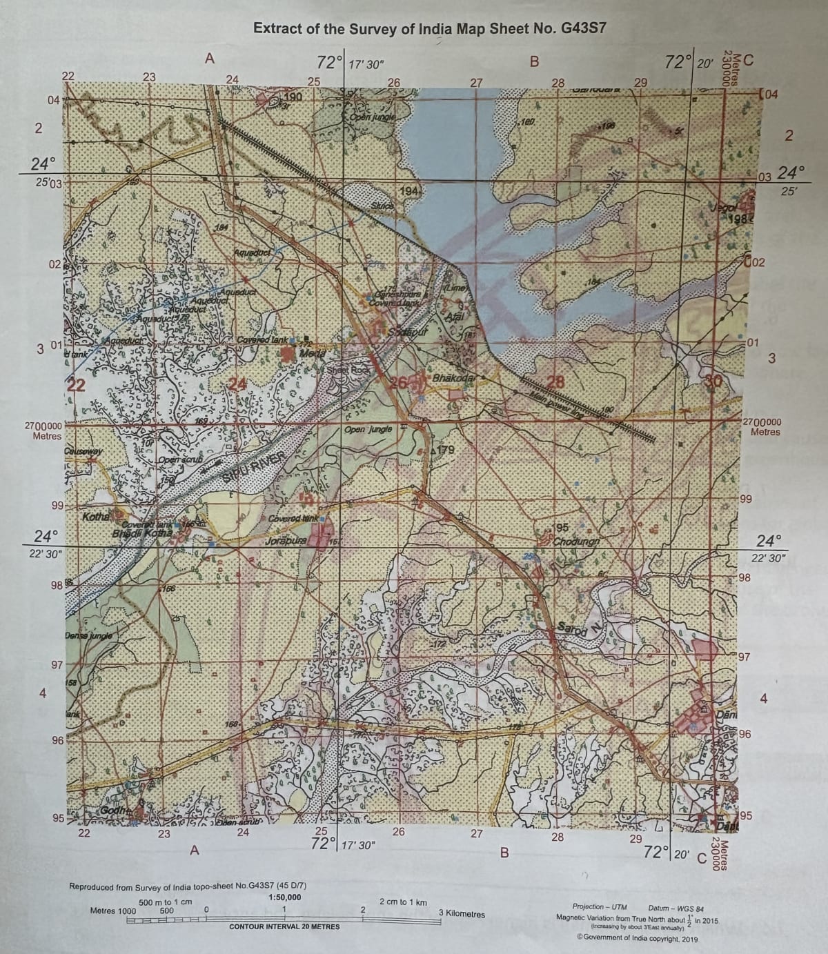
(i) Write the scale of the map in the form of a statement.
(ii) Identify the stream that flows parallel to the Sipu River on its south.
(iii) What do the broken black lines along Sipu Nadi stand for?
(iv) What does the double red line in 2202 of the map mean?
(v) What does the arrow in the Sipu River mean?
(vi) What are the sources of water in the following settlements?
(a) Bhadli Kotha
(b) Sodapur
(vii) Describe the type of vegetation on the map.
Answer
(i) 2 cm on the map represents 1 km on the ground.
Explanation:
The scale of the map is 1:50,000. Written in the form of a statement (verbal statement), it reads: 2 cm on the map represents 1 km on the ground (that is, 1 cm represents 500 metres).
(ii) The stream is Sarod Nala.
(iii) The broken black lines along Sipu Nadi stand for broken ground.
(iv) The double red line in grid square 2202 represents a metalled road.
Explanation:
On topographical maps, metalled roads are shown by double lines in red colour with orange in between.
(v) The arrow in the Sipu River shows the direction of flow of the river.
(vi) The sources of water in the settlements are:
(a) Bhadli Kotha — a covered tank.
(b) Sodapur — a covered tank.
(vii) The vegetation shown on the map is mainly open jungle (open forest) and open scrub — that is, sparse and scattered vegetation rather than dense forest.
Study the extract of the Survey of India topographical sheet no. G43S7 (Eastings 22 to 30 and Northings 95 to 04) given on this page and answer the following questions:
(i) Two manmade features to the north west of the map.
(ii) Two natural features near Meda.
(iii) a culture feature near Godh.
(iv) Which part of the map is higher? Study the spot heights and answer.
Answer
(i) Aqueduct and covered tank. (Roads and cart tracks are also seen in this part.)
(ii) The Sipu River and Sheet Rock are two natural features near Meda.
(iii) A cultural (human-made) feature near Godh is a cart track.
(iv) The north-eastern part of the map is the highest. The highest spot height shown is 198 m near Jegol. Other comparatively high spot heights include 194 m in the northern part and 195 m farther east, while lower spot heights such as 158 m, 160 m, 168 m and 169 m occur mainly in the western and south-western parts.