
Refer to the extract of the Survey of India Map Sheet No. G43S7 and the answer the questions that follow:
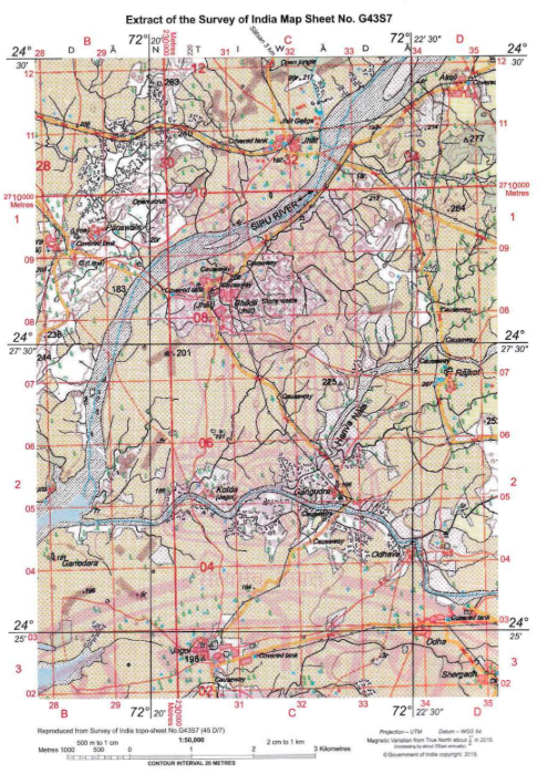
Use a divider and a scale to measure the following distances and write in the blank space provided.
(i) Measure the distance from Jegol to Odhava by the cart track ............... .
(ii) What is the straight distance between Panswala and Gangudra? ............... .
(iii) The bank of the Sipu River is ............... kms from Jegol.
(iv) The two natural features near Gangudra are ............... and ............... .
Answer
(i) The distance from Jegol to Odhava by the cart track is approximately 2.75 km.
(ii) The straight distance between Panswala and Gangudra is approximately 4.75 km.
(iii) The nearest bank of the Sipu River is approximately 2.25 km from Jegol.
(iv) The two natural features near Gangudra are Hanra Nala and broken ground.
Refer to the extract of the Survey of India Map Sheet No. G43S7 and the answer the questions that follow:
Identify the following:
(i) The red squares in Jegol.
(ii) The blue dots near Jegol.
(iii) The red line connecting Jegol to Kotda.
(iv) The green patch to the south of Akoli.
(v) The white patches on the banks of the Sipu River.
(vi) The black line showing 72° 20'.
Answer
(i) The red squares in Jegol represent permanent huts (settlement).
(ii) The blue dots near Jegol represent wells.
(iii) The red line connecting Jegol to Kotda is a cart track.
(iv) The green patch to the south of Akoli represents vegetation (a forested area / open jungle).
(v) The white patches on the banks of the Sipu River represent sand / barren (waste) land.
(vi) The black line showing 72° 20' is a line of longitude.
In which layer of the atmosphere is moisture available in sufficient quantities?
- mesosphere
- ionosphere
- exosphere
- troposphere
Answer
troposphere
Reason — The troposphere contains almost all the dust particles and water vapour present in the atmosphere, so moisture is available there in sufficient quantities. The mesosphere, ionosphere (thermosphere) and exosphere are upper layers far above the surface where water vapour is negligible.
Which of the following devices release Ozone Depleting Substances (ODSs)?
- fire extinguisher, LPG cylinder
- microwave oven, mobile phone
- refrigerator, air conditioner
- locomotives, bulldozers
Answer
refrigerator, air conditioner
Reason — ODS such as CFCs may be released from junk refrigerators and air conditioners. Therefore, refrigerator and air conditioner form the pair in which both devices can release ODS.
Which of the following are correctly matched?
| Elements of Climate | Features |
|---|---|
| A. Temperature | 1. It decreases with a decrease in altitude. |
| B. Humidity | 2. It increases in summer and not in winter. |
| C. Precipitation | 3. It is more on the leeward side of the mountains. |
| D. Wind | 4. It is offshore during summers. |
Which option is correct?
- A. and 1. are correct
- B. and 2. are correct
- C. and 3. are correct
- D. and 4. are correct.
Answer
B. and 2. are correct
Reason — Higher humidity is experienced during summer as warm air expands and can hold more moisture, so B–2 is correctly matched. A is wrong because temperature decreases with an increase in altitude (the higher the altitude, the lower the temperature); C is wrong because precipitation is greater on the windward side, the leeward side lying in the rain shadow; and D is wrong because winds blow onshore, not offshore, during summers.
A rock that contains fossils.
- granite
- diamond
- limestone
- basalt
Answer
limestone
Reason — Limestone is a sedimentary rock, and sedimentary rocks contain the fossils of plants and animals trapped between layers of sediments. Granite and basalt are igneous rocks and diamond is formed by extreme metamorphism, and igneous and metamorphic rocks do not contain fossils.
Soil can be conserved by one of the following methods:
- crop rotation
- grazing cattle in one plot
- deforestation
- growing same crop again and again
Answer
crop rotation
Reason — Crop rotation helps replenish soil fertility and conserve the soil. Grazing cattle continuously in one plot can lead to overgrazing, deforestation leaves the soil loose and exposed, and growing the same crop repeatedly depletes the soil and increases the risk of erosion.
Two statements are given in the question below as Assertion (A) and Reason (R). Read the statement and choose the appropriate option:
Assertion (A): Weather forecast is the prediction of weather conditions.
Reason (R): Weather forecasts help in ocean navigation and fishing.
- Both (A) and (R) are true but (R) is not the correct explanation for (A).
- Both (A) and (R) are true and (R) is the correct explanation of (A).
- (R) is true but (A) is false.
- (A) is true but (R) is false.
Answer
Both (A) and (R) are true but (R) is not the correct explanation for (A).
Explanation — Weather forecast is indeed the prediction of weather conditions issued by the meteorological departments, so A is true. It is also true that weather forecasts help in ocean navigation and fishing, so R is true. However, R states a use or benefit of weather forecasting, whereas A defines what a weather forecast is; a use of forecasting does not explain its definition. Hence R is not the correct explanation of A.
Isotherms are lines joining
- places having equal heights.
- places having equal pressure.
- places having equal temperature.
- places getting same amount of rainfall.
Answer
places having equal temperature.
Reason — Isotherms are lines joining places having equal temperature; 'iso' means same and 'therm' means heat.
Melting of polar ice caps is taking place due to
- global warming.
- rise in salinity of the sea.
- drying up of rivers.
- deforestation.
Answer
global warming.
Reason — Global warming raises global temperatures and causes the melting of glaciers and permanent ice sheets in the Arctic and Antarctic regions.
Global warming will lead to
- an increase in the density of air.
- change in the ions of the ionosphere.
- cyclones and hurricanes in coastal areas.
- rise in green cities.
Answer
cyclones and hurricanes in coastal areas.
Reason — As rainfall patterns change with global warming, tropical cyclones and hurricanes become a common occurrence, which is a recognised impact of global warming.
The main objective of the Montreal Protocol was
- to increase global forest cover.
- to reduce pollution of water bodies.
- to lower the production of Ozone Depleting Substances.
- to increase consumption of fossil fuels.
Answer
to lower the production of Ozone Depleting Substances.
Reason — The chief objective of the Montreal Protocol was to reach a global agreement to reduce the production of Ozone Depleting Substances (ODS).
What are ions? Why is their presence in the atmosphere significant?
Answer
Ions are electrically charged particles formed when molecules of atmospheric gases break up in the thermosphere.
Their presence is significant because they reflect radio waves back to the Earth and enable radio broadcasts and wireless communication. This region of the thermosphere is known as the ionosphere.
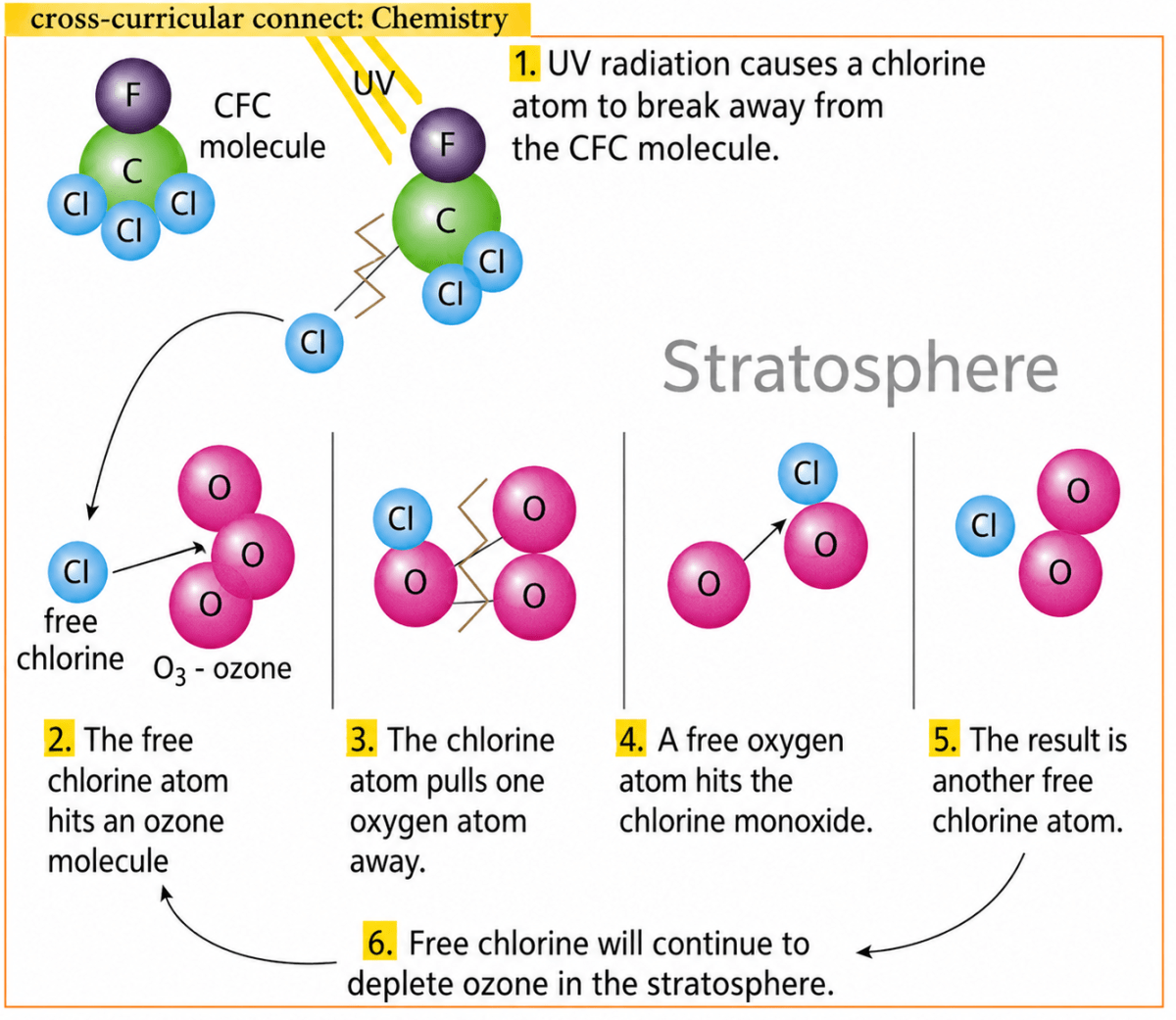
Discuss how an ozone hole is created.
Answer
Certain human activities release CFCs and other Ozone Depleting Substances (ODS) into the atmosphere. These substances release chlorine, which destroys ozone through the following process:
- UV radiation causes a chlorine atom to break away from a CFC molecule.
- The free chlorine atom hits an ozone molecule.
- The chlorine atom pulls one oxygen atom away from the ozone molecule, forming chlorine monoxide.
- A free oxygen atom hits the chlorine monoxide.
- Another free chlorine atom is released and continues to destroy more ozone.
Thus, repeated destruction of ozone causes the ozone layer to become thin and creates an ozone hole.
Define atmosphere.
Answer
The atmosphere is a mixture of gases that form a layer surrounding the Earth. It is held in place by the gravitational force of our planet and forms the vital gaseous realm of the Earth.
Name the different layers of the atmosphere.
Answer
The five different layers of the atmosphere are:
- Troposphere
- Stratosphere
- Mesosphere
- Thermosphere
- Exosphere
How does rainfall occur?
Answer
Rainfall occurs due to the condensation of water vapour into tiny droplets of water. These droplets coalesce to form larger droplets and clouds. When the clouds become too heavy, the water cannot remain suspended in the air and comes down as rain. Rain is the most common form of precipitation.
How are clouds formed?
Answer
When warm air rises, it expands and cools. Cold air can hold less moisture than warm air, so the air soon becomes saturated. When the dew point is reached, further cooling causes water vapour to condense around small particles of dust called condensation nuclei. These minute water droplets gather together to form clouds.
Name the factors that influence atmospheric pressure. Explain in brief.
Answer
Atmospheric pressure depends on factors such as altitude, temperature, moisture content and rotation of the Earth.
- Altitude — As we reach higher altitudes, pressure drops as the air becomes thinner or less dense.
- Temperature — If temperature rises, the air expands and rises. The air becomes less dense and exerts less pressure. Regions with lower temperature have denser air, which sinks to create high-pressure zones.
- Moisture content — Wet air exerts less pressure than dry air.
- Rotation of the Earth — The rotation of the Earth deflects winds and either causes them to pile up to form high-pressure zones (subtropical high pressure zone) or scatters them to form low-pressure zones (subpolar low pressure zone).
Name the two scales in which temperature is measured. State the boiling point and freezing point of water in each of the scales.
Answer
Temperature is measured in two scales — the Fahrenheit scale and the Celsius scale.
- In the Fahrenheit scale, the freezing point of water is 32°F and the boiling point is 212°F.
- In the Celsius scale, the freezing point of water is 0°C and the boiling point is 100°C.