
What are the unique physical features of the continents?
Answer
The continents have distinct physical features such as mountains, plateaus, plains, deserts, grasslands, rivers and lakes. For example, Asia has the Tibetan Plateau and the Gobi Desert; Europe has the European Plain and the Alps; Africa has the Sahara Desert, the Savannah and the River Nile; South America has the Andes Mountains and the Amazon Rainforest; North America has the Rocky Mountains, the Colorado Plateau and the Great Lakes; Australia has vast desert regions; and Antarctica is an ice-covered continent and the world’s largest cold desert. These features influence the climate, vegetation, wildlife and human activities of each continent.
Why do we need to understand world geography?
Answer
We need to understand world geography for the following reasons:
- It helps us understand the varied landforms and water bodies of the Earth, such as mountains, plateaus, plains, deserts, grasslands, rivers and oceans, and the natural processes like tectonic movements, erosion and deposition that shape them.
- These features influence climate, ecosystems and human activities such as settlement, agriculture and trade.
- Distant places are connected to our lives. For example, the distant Southern Indian Ocean influences the monsoon in the Gangetic Plains, and dust from the Sahara carries phosphorus needed by plants in the Amazon Rainforest.
- It shows how human actions like deforestation and pollution disturb the balance of nature, and why these features must be managed wisely for sustainable development.
How do human actions trigger environmental issues?
Answer
Human actions such as deforestation, pollution and overuse of natural resources disturb the balance of ecosystems. They can lead to biodiversity loss, desertification and climate change. Activities like overfishing, industrial pollution and excessive waste also damage oceans, forests and other natural habitats.
Assess and describe the Himalayas from the perspective of these different roles.
Answer
The Himalayas perform several important geographical roles:
- They were formed by the collision of the Indo-Australian and Eurasian tectonic plates.
- They influence the climate of the Indian subcontinent by acting as a high mountain barrier.
- They act as ‘water towers’, as their snow and glaciers feed major rivers such as the Indus and Brahmaputra.
- Their varied heights support rich biodiversity, and they also form an important natural boundary in northern India.
Thus, the Himalayas are important for climate, freshwater, biodiversity and geographical boundaries.
Observe the area covered by the European Plain. Now turn to the political map of the world at the end of this textbook. List the countries that are part of the European Plain (you need not memorise them).
Answer
The European Plain extends across parts of several countries, including France, Belgium, the Netherlands, Germany, Poland, Belarus, Ukraine and Russia. It is one of the largest continuous flatland regions in the world.
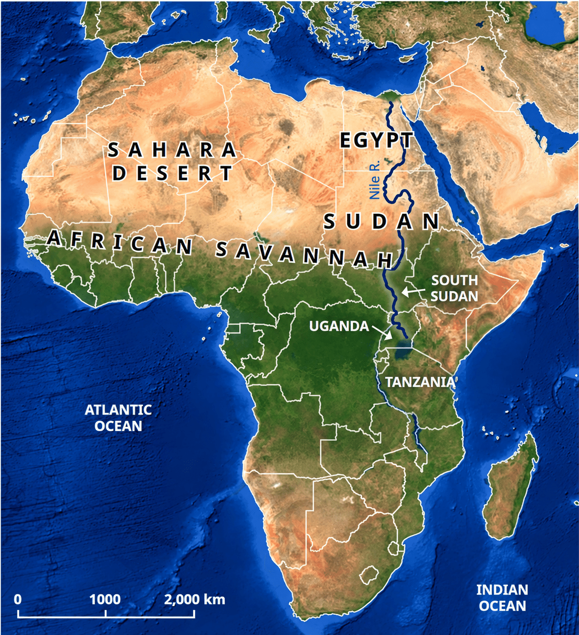
On the map (Fig. 1.22) locate the course of the River Nile. Where does it originate from and in which direction does it flow? Turn to the political map at the end of the book, and identify some of the areas that the river flows through.
Answer
The River Nile originates in the Lake Victoria region of East Africa and flows mainly northwards. It passes through areas such as Uganda, South Sudan, Sudan and Egypt, and finally drains into the Mediterranean Sea. The Nile and its basin have supported agriculture, settlements and civilisation for thousands of years.
The Amazon Rainforest has been called the 'Lungs of the Earth'. Why do you think this might be so?
Answer
The Amazon Rainforest has been called the ‘Lungs of the Earth’ because:
- It is a vast area of tall, mostly evergreen trees that receives a high amount of rainfall and is supported by the Amazon River and its tributaries.
- Just as lungs help us breathe, these trees absorb carbon dioxide from the air and release oxygen during photosynthesis.
- By absorbing carbon dioxide on such a large scale, the forest helps to reduce the greenhouse effect and maintain the balance of the Earth’s climate.
Thus, the Amazon Rainforest supports life far beyond South America.
The countries in this region need land for development but risk losing the Amazon Rainforest. Discuss in groups: What are the short and long-term effects of deforestation, and how can we protect the Amazon for the planet?
Answer
Deforestation of the Amazon Rainforest can have serious short- and long-term effects.
- Short-term effects: Loss of trees destroys habitats and reduces biodiversity. It can also disturb the lives of indigenous communities who depend on the forest.
- Long-term effects: Continued deforestation can contribute to climate change, loss of flora and fauna, and disturbance of the natural balance of the ecosystem.
- Protection: The Amazon can be protected by controlling deforestation, conserving biodiversity, using forest resources sustainably, and involving indigenous communities in conservation efforts. Nearly 400 indigenous communities live in the forest and play an important role in protecting it.
Thus, protecting the Amazon is important for maintaining biodiversity and global environmental balance.
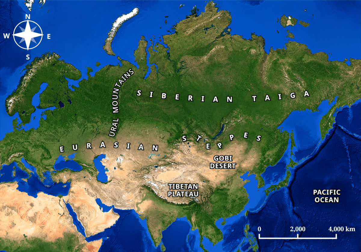
Study the map in Fig.1.11. What are the different physical features represented here? (Hint: You may refer to LET’S EXPLORE on page 2 of this chapter.)
Answer
The physical map of Asia shows the Tibetan Plateau (a high plateau), the Gobi Desert (a cold desert), the Eurasian Steppes (vast grasslands), the Ural Mountains (a mountain range), the Siberian Taiga (a forest region) and the Pacific Ocean (a water body). The map's colours and labels help us identify these features.
Oceans give us almost half the oxygen we breathe. Tiny marine organisms, such as plankton, make this possible. What do you think would happen to all living beings if pollution harmed these planktons, and they could no longer produce enough oxygen?
Answer
If pollution harmed plankton and they could no longer produce enough oxygen:
- Less oxygen: Oceans give almost half the oxygen we breathe, so the oxygen available to humans, animals and other living beings would fall sharply.
- Loss of marine life: Oceans support life from tiny plankton to giant blue whales. Fish, whales and other sea animals that depend on plankton directly or indirectly for food would decline.
- More carbon dioxide: Plankton use sunlight and carbon dioxide to make food. Without them, more carbon dioxide would remain in the air, adding to climate change.
- Effect on humans: Communities that depend on fishing for food and livelihood would suffer.
Thus, harm to plankton would affect all living beings, both in the oceans and on land.
Why do all map projections have some amount of distortion?
Answer
All map projections have some distortion because the Earth is an oblate spheroid, while a map represents it on a flat surface. Therefore, it is not possible to represent the Earth perfectly without distorting its shape, size or distance to some extent.
What makes the Tibetan Plateau unique?
Answer
The Tibetan Plateau is unique because:
- It is the highest and largest plateau on Earth and is called the ‘Roof of the world’.
- It was formed by the collision of the Indo-Australian and Eurasian tectonic plates, which also formed the Himalayan mountain range.
- It stretches about 2,500 km from east to west and 1,000 km from north to south, with an average height of over 4,500 metres above sea level.
- It influences the climate of Asia and is the source of many major rivers, including the Indus, Brahmaputra and Yangtze.
- Along with its mountains, it is called the ‘Third Pole’, as it contains the largest reserves of freshwater outside the polar regions.
Why are coral reefs called the 'rainforests of the sea'?
Answer
Coral reefs are called the ‘rainforests of the sea’ because, like rainforests on land, they are among the most diverse ecosystems on Earth. They provide food and shelter for about one-quarter of all ocean species, including fish, crabs, turtles and sponges. For example, the Great Barrier Reef houses hundreds of species of coral and thousands of species of fish and other sea animals.
How do the oceans help to regulate the Earth's climate?
Answer
The oceans help to regulate the Earth’s climate in the following ways:
- Absorbing and releasing heat: Oceans absorb heat and release it slowly, which moderates the temperature of the Earth.
- Adding moisture: They add moisture to the air, which forms clouds and rainfall. For example, the distant Southern Indian Ocean influences the monsoon in the Gangetic Plains.
- Ocean currents: Warm currents carry warm water from the equator towards the poles, while cold currents carry cold water from the poles towards the equator. These currents affect the climate of coastal areas. For example, the warm Gulf Stream flows north through the Atlantic Ocean towards Western Europe and makes places like the United Kingdom warmer than other places at the same latitude.
What is the main reason for the Great Barrier Reef facing threats today?
Answer
The Great Barrier Reef is threatened mainly by human activities, especially climate change, as well as pollution and overfishing. Rising ocean temperatures are a leading cause of widespread coral bleaching. When seawater becomes too warm, corals may lose the tiny algae that live within them, causing them to turn white. Bleached corals are stressed and may recover if conditions improve, but prolonged bleaching can kill them and destroy habitats for marine animals. Hence, conserving the reef and reducing these threats are crucial.
Why is the Amazon Rainforest often called the 'Lungs of the Earth'?
Answer
The Amazon Rainforest is often called the ‘Lungs of the Earth’ because its vast area of dense, tall and mostly evergreen trees absorbs large amounts of carbon dioxide from the air and releases oxygen through photosynthesis, just as lungs help us breathe. In this way, it helps to purify the air, reduce the greenhouse effect and maintain the Earth’s climate balance. This is why the deforestation of the Amazon is a concern for the whole planet.
Choose two different types of geographical features you have explored in this chapter. Write short paragraphs on how they influence the flora and fauna or human lives in that area. Do they also have an implication for the whole globe?
Answer
Two different geographical features that I have chosen are:
The Eurasian Steppes: The Steppes are vast temperate grasslands that support grazing animals, migratory birds and the livelihood of nomadic communities. They also act as a global carbon sink by absorbing carbon from the atmosphere and storing it underground, helping to reduce the greenhouse effect.
The Amazon Rainforest: The Amazon Rainforest supports rich flora and fauna and is home to nearly 400 indigenous communities. It also plays an important role in maintaining the Earth’s environmental balance. Deforestation and climate change threaten this ecosystem and can have effects far beyond South America.
Discuss how oceans influence climate and trade. Use examples from the Indian and Pacific Oceans.
Answer
Oceans influence both the climate and the trade of the lands around them.
- Influence on climate
- Oceans absorb heat, release it slowly and add moisture to the air, forming clouds and rainfall.
- Indian Ocean: The distant Southern Indian Ocean influences the monsoon in the Gangetic Plains. The Bay of Bengal, the world’s largest bay, also influences the climate of the region.
- Pacific Ocean: Being the largest and deepest ocean, the Pacific absorbs and stores huge amounts of heat and moisture, which affect the temperature and rainfall of the lands around it.
- Influence on trade
- Indian Ocean: Its warm waters have been historically important for international trade. The Persian Gulf has been important for trade between India and Europe for millennia, and the Suez Canal, connecting the Red Sea with the Mediterranean, is the shortest maritime route from India to Europe. Bays such as the Bay of Bengal provide safe havens for ports and dockyards.
- Pacific Ocean: It links the countries of Asia with the Americas and is rich in marine life such as whales and tuna, which supports fishing. The Strait of Malacca joins the Indian Ocean with the Pacific Ocean and is an important route for ships.
Thus, oceans shape the climate of the continents and connect countries through trade and transport.
Choose one environmental issue (deforestation, reef bleaching, or desertification) and explain its causes, impacts, and possible solutions.
Answer
One important environmental issue is reef bleaching.
- Causes
- Reef bleaching occurs due to changes in the chemical composition of ocean water, largely caused by human activities.
- Pollution, overfishing and climate change also threaten coral reefs.
- Impacts
- Bleaching can lead to the death of corals.
- It causes the loss of habitat for many marine animals.
- This reduces marine biodiversity.
- Possible Solutions
- Reduce pollution entering the oceans.
- Control overfishing.
- Protect coral reefs through conservation measures and reduce activities that contribute to climate change.
Imagine you are a geographer asked to advise a government about protecting one major landscape in your country. Which one would you choose, and why?
Answer
As a geographer, I would advise the government to protect the Himalayas for the following reasons:
- Water towers: Their snow and glaciers feed major rivers such as the Indus, Ganga and Brahmaputra, which provide freshwater for drinking, irrigation and hydroelectric power to millions of people.
- Climate: They act as a high mountain barrier that influences the climate of the Indian subcontinent.
- Biodiversity hotspot: Their varied heights support rich flora and fauna.
- Natural boundary: They form an important natural boundary in the north of India.
- Threats: Climate change is causing snow and glaciers to melt, while deforestation and pollution damage the fragile mountain ecosystem.
Suggested measures: Control deforestation, reduce pollution, promote sustainable tourism, protect wildlife habitats and involve local communities in conservation.
Thus, protecting the Himalayas is essential for freshwater, climate, biodiversity and the lives of millions of people.