
What shapes the Earth’s surface?
Answer
The Earth’s surface is constantly transformed by forces operating both inside the Earth and on its surface.
- Internal (Endogenic) forces — Processes like earthquakes, volcanic eruptions, folding, and faulting build up large surface features such as mountains, valleys, and ocean basins. These movements are linked to tectonic plates moving over the semi-molten asthenosphere.
- External (Exogenic) forces — Weathering and erosion slowly break down and wear away the landforms created by internal forces.
- Agents of gradation — Running water, glaciers, wind, waves and groundwater continuously modify landforms by lowering high areas and filling up low areas.
Together, these forces shape all the diverse landforms across the globe, from deep ocean trenches to high mountain peaks.
What is plate tectonics? What are the effects of plate movement?
Answer
Plate tectonics, a theory introduced by W. J. Morgan, explains how the Earth’s lithosphere is broken into several large and small slabs called tectonic plates. These plates move slowly, at a rate of a few centimetres each year, over the semi-molten asthenosphere beneath them. Heat from the Earth’s interior drives convection currents in the mantle, in which hotter material rises and cooler material sinks, continuously pushing and pulling the plates.
Effects of plate movement:
- At convergent boundaries — Plates move toward each other. Colliding continental plates form fold mountains like the Himalayas. When an oceanic plate collides with a continental plate, the heavier oceanic plate sinks below, causing earthquakes and volcanic eruptions.
- At divergent boundaries — Plates pull apart from one another. Magma rises from the mantle to form new crust, creating underwater features like the Mid-Atlantic Ridge.
- At transform boundaries — Plates slide sideways past each other without creating or destroying crust. This grinding movement triggers earthquakes, such as along the San Andreas Fault.
- Plate movement distributes continents and oceans, creates valleys and ocean basins, and causes most volcanic eruptions and earthquakes, particularly around the Pacific Ring of Fire.
How are landforms formed and how are they classified?
Answer
A landform is a natural feature on the Earth's surface created by tectonic movements, weathering, erosion, and deposition.
Formation — Internal forces elevate and build major landforms like mountains, plateaus, and valleys. External weathering then breaks rocks down in place, while erosion wears materials away and moves them to new locations where they are deposited. Agents of gradation use these processes to carve and smooth out land features over time.
Classification according to the agent that creates them:
| Sn. No. | Agent of gradation | Landforms formed |
|---|---|---|
| 1. | Running water | V-shaped valleys, waterfalls and rapids in the upper course; meanders, oxbow lakes and floodplains in the middle course; deltas, levees and alluvial fans in the lower course. |
| 2. | Waves and currents | Beaches, sand bars, sea cliffs, wave-cut platforms, sea caves, arches and stacks. |
| 3. | Glaciers | U-shaped valleys, cirques, aretes, hanging valleys, fjords and moraines (lateral, terminal and medial). |
| 4. | Wind | Yardangs, ventifacts, deflation hollows or blowouts, desert pavements and dunes (barchan, longitudinal, star and parabolic). |
| 5. | Underground water | Karst topography — caves, stalactites, stalagmites, pillars, sinkholes or dolines, and underground rivers. |
How are humans and other living beings connected to these landforms?
Answer
Landforms shape where people live, how they work, and how human history develops:
- Agriculture and settlement — Fertile river valleys and plains (such as the Ganga, Indus, Nile, and Brahmaputra) allowed early human civilisations and cities to thrive. Rich alluvial soils on river deltas and meanders support major crops like rice and jute.
- Water and power — Glaciers supply fresh water to rivers that millions rely on downstream. Waterfalls are harnessed to generate hydroelectric power, and moraines often form natural reservoirs for irrigation and water storage. Caves and underground rivers provide sources of fresh water.
- Trade and transport — Deltas and meandering rivers provide navigable routes and are centres of trade and transportation. Fjords are used for harbours and fishing. Coasts and harbours supported trade, travel and cultural contacts with distant lands, helping kingdoms like those in south India flourish.
- Tourism and recreation — Scenic landforms including waterfalls, beaches, desert dunes, caves, and glacial valleys attract tourists, boosting local businesses.
- Protection — Mountains acted both as barriers and protectors — the Himalayas shielded India from invasions but also allowed cultural exchanges through passes like the Khyber pass. Beaches act as natural barriers against strong waves and coastal erosion, and dunes act as natural barriers against desertification and wind erosion.
- Limits set by landforms — Deserts, such as the Thar, limited the development of large settlements but encouraged trade routes such as the Silk Route. Landforms also influence settlement patterns and agriculture in arid regions.
- Habitats, culture and belief — Landforms provide habitats for plants and animals; for example, deltas and wetlands support mangroves, fish, birds and other aquatic life. Natural landforms such as caves, waterfalls, rivers and mountains also hold cultural and spiritual meaning in many traditions.
How do disasters associated with different landforms impact human lives?
Answer
Disasters are often directly linked to specific landform features. Their impacts on human lives include:
- Mountainous & Hilly Landforms (Landslides, Avalanches, Glacial Lake Outburst Floods) — can cause loss of life, damage villages, roads, bridges and settlements, and disrupt transportation and communication. They can also destroy infrastructure such as hydroelectric power projects and cut off remote communities from essential supplies and emergency services.
- River Valleys & Plains (Floods & Bank Erosion) — In low-lying plains, severe floods can submerge crops and damage agricultural livelihoods, while riverbank erosion can wash away homes and fertile farmland, displacing families.
- Coastal Landforms (Tsunamis, Storm Surges & Coastal Erosion) — Severe wave action and storm surges can cause loss of life and damage coastal communities, while coastal erosion can destroy beaches and infrastructure, affecting tourism, shipping and fishing.
- Tectonic Belts & Plate Boundaries (Earthquakes & Volcanic Eruptions) — Earthquakes can cause severe loss of life and property by collapsing buildings and bridges, especially in densely populated areas, while volcanic eruptions can release ash and gases that damage crops, pollute water sources, affect health and disrupt air transport.
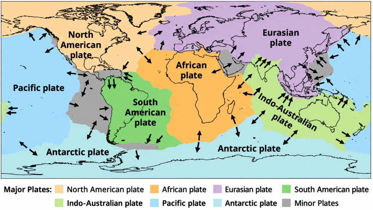
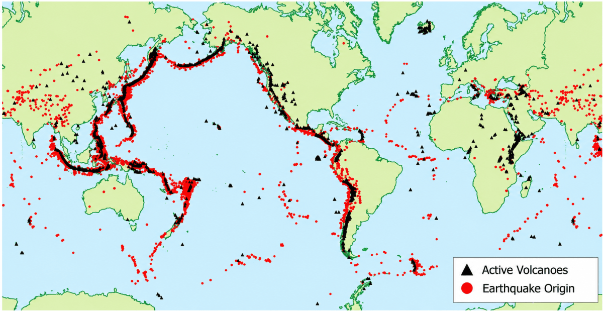
Examine the plate map (Fig. 2.3) with the earthquake and volcano map (Fig. 2.4). What correlation do you observe?
Answer
Comparing both maps reveals that earthquake locations and active volcanoes line up directly with tectonic plate boundaries:
- Most earthquakes and volcanoes occur along plate boundaries and very few occur in the interiors of the plates.
- The densest belt lies around the margins of the Pacific plate, where it meets the Eurasian, Indo-Australian, North American, South American and Antarctic plates. This horseshoe-shaped belt is known as the Ring of Fire.
- Another continuous belt is seen along the convergent boundary of the Indo-Australian and Eurasian plates, that is, along the Himalaya and further westward.
- A line of earthquakes is also seen along the mid-ocean ridges, such as the Mid-Atlantic Ridge, which is a divergent boundary.
This shows that plate movements are responsible for the distribution of earthquakes and volcanoes.
Observe the map showing the distribution of earthquakes and volcanoes (Fig. 2.4). Can you identify which continents and countries are located around the Ring of Fire with the help of an atlas or a globe?
Answer
The Ring of Fire encircles the Pacific Ocean and touches four continents — Asia, North America, South America and Oceania.
Countries lying along it are:
- Asia — Russia (Kamchatka), Japan, Taiwan, the Philippines, Indonesia.
- North America — the United States of America (Alaska and California), Canada, Mexico, Guatemala, Costa Rica, El Salvador, Nicaragua and Panama.
- South America — Colombia, Ecuador, Peru, Chile.
- Oceania — Papua New Guinea, Solomon Islands, Fiji, Tonga, New Zealand.
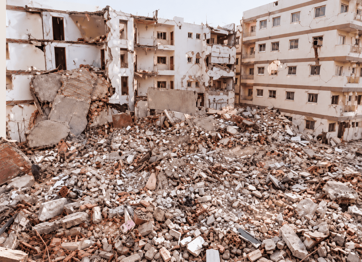
Does India have a risk of earthquakes? India has experienced some major earthquakes in the past, resulting in thousands of deaths. A large earthquake in a densely populated country like India can cause severe damage to life and environment. Can you find out which region is more vulnerable to earthquakes? Why do you think human lives are at risk?
Answer
Yes, India faces a significant risk of severe earthquakes because a large part of the country lies near active tectonic plate boundaries.
Most Vulnerable Regions —
- The Himalayan Belt: The northern and north-eastern regions are highly vulnerable to earthquakes because the Indo-Australian Plate is actively colliding with the Eurasian Plate. It includes Jammu and Kashmir, Ladakh, Himachal Pradesh, Uttarakhand, Sikkim, north Bihar and the north-eastern states.
- Other High-Risk Zones: The Kachchh region of Gujarat, where the devastating earthquake of 2001 occurred, and the Andaman and Nicobar Islands are also highly prone to severe seismic activity.
Why human lives are at risk —
- India is a densely populated country, so a single earthquake affects a very large number of people.
- Many buildings are old or are constructed without following earthquake-resistant designs, and they collapse easily.
- Unplanned construction on hill slopes and in river valleys increases the damage, as earthquakes may also trigger landslides and avalanches.
- Earthquakes cannot be predicted, so people get no time to move to safety.
Look carefully at this photograph and answer the following question:
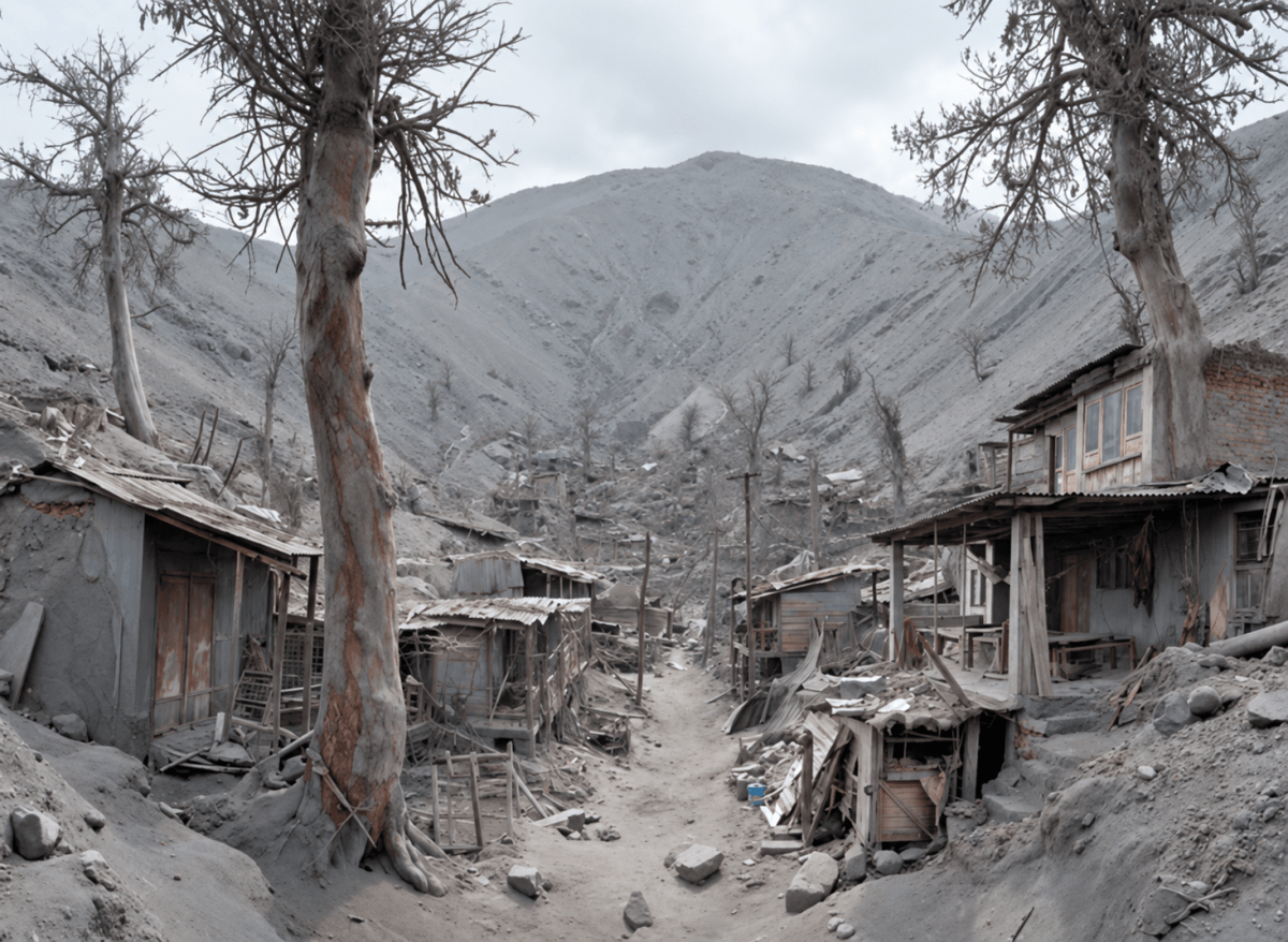
(i) What do you think caused this situation?
(ii) What could that grey powder be?
(iii) What does it tell us about the Earth’s internal forces?
Answer
(i) The situation was caused by a volcanic eruption nearby. Material thrown out during the eruption settled over the area, coating the ground, houses and vegetation.
(ii) The grey powder is volcanic ash — the fine, dust-like material deposited by the volcanic eruption.
(iii) It shows that the Earth’s internal forces are powerful and dynamic. Magma and gases from within the Earth can rise through cracks or weak zones in the crust, causing eruptions that rapidly reshape the landscape and affect settlements and living beings.
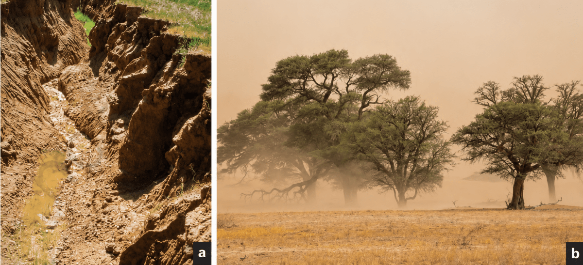
Observe the photographs (Fig. 2.9) and also note the types of erosion. How are farmers affected by erosion due to water and wind?
Answer
The photographs show (a) water erosion, caused by rivers, rain or ocean waves, and (b) wind erosion, which is common in dry and sandy areas.
Impact of Water Erosion on Farmers:
- Loss of Fertile Topsoil: Surface run-off washes away nutrient-rich topsoil, reducing crop productivity.
- Gully Formation: Uncontrolled run-off forms deep gullies, making farmland difficult to cultivate.
- Damage to Infrastructure: Heavy run-off washes away seeds, seedlings, field boundaries and irrigation channels.
Impact of Wind Erosion on Farmers:
- Removal of Fine Soil Particles: Strong winds remove loose topsoil and organic matter, leaving coarse, infertile soil.
- Crop Damage: Blowing sand and dust bury crops and damage young plants, reducing crop yields.
- Loss of Soil Moisture: Wind erosion dries the soil, increasing the need for irrigation.
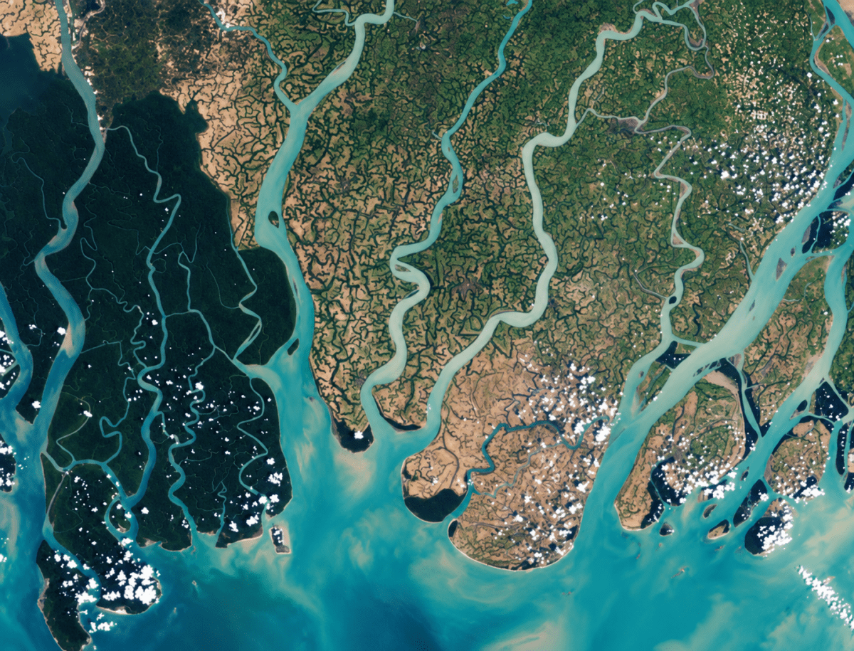
Have you heard about the Sundarbans delta? Try and explore its uniqueness and find out why it is popular with tourists.
Answer
The Sundarbans is the delta formed at the mouth of the Ganga, the Brahmaputra and the Meghna where they flow into the Bay of Bengal. It is shared by India and Bangladesh.
Its uniqueness:
- It is the largest delta in the world, made of the sediments deposited by these rivers over thousands of years.
- It has the largest mangrove forest in the world. The mangrove trees can survive in salty water and hold the soil together with their stilt roots.
- It is a maze of low, flat islands separated by innumerable distributaries, creeks and tidal channels.
- The mixing of fresh and saltwater creates diverse aquatic life, which makes it rich in fish and other marine life.
- It is the natural home of the Royal Bengal Tiger and also of the estuarine crocodile, spotted deer and a large variety of birds. It has been declared a National Park, a Biosphere Reserve and a UNESCO World Heritage Site.
- The mangroves act as a natural shield that protects the coast from cyclones and storm surges.
Tourism Appeal: Visitors come to explore the scenic waterways and tidal creeks by boat, observe wildlife and birds, experience the unique mangrove environment, and learn about local culture.
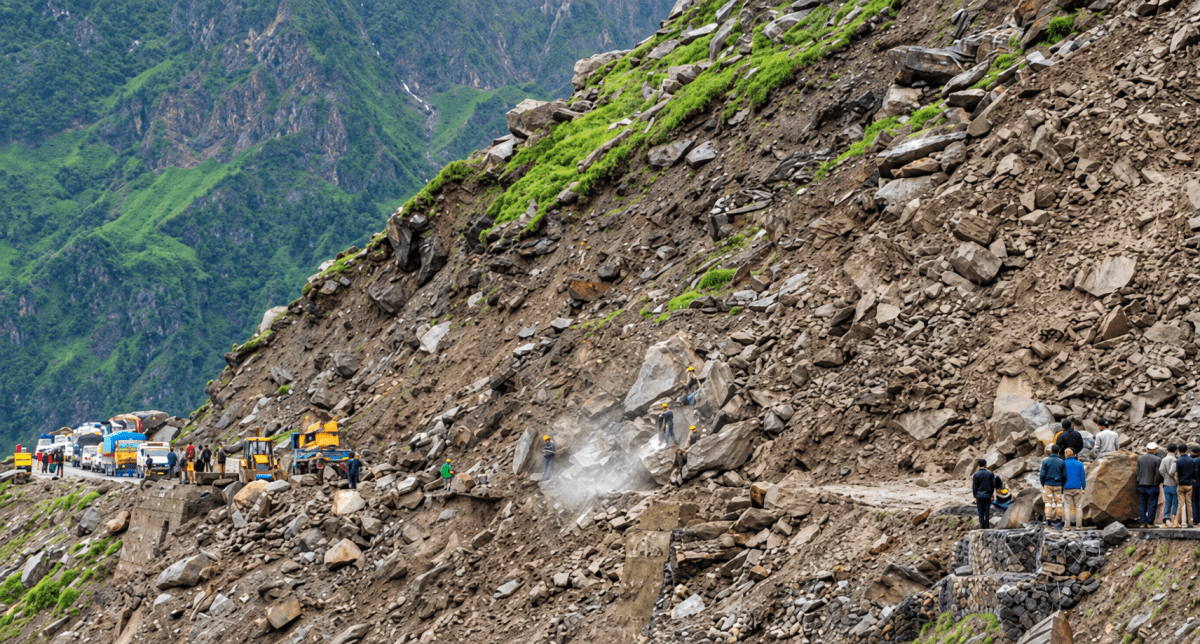
Identify the disaster and make a list of disaster-prone areas from India and the world and enlist mitigation measures quoting recent examples.
Landslides are caused by a combination of natural and human factors that make slopes unstable. Heavy and continuous rainfall is one of the main natural causes, as water seeps into the soil and rocks, increasing their weight and reducing friction. Earthquakes and volcanic eruptions can also trigger landslides by shaking the ground and weakening slopes. Steep slopes and the presence of loose or weathered rocks further increase the risk. Human activities, such as deforestation, mining, road construction, and unplanned construction on hillsides disturb the natural balance of slopes. Poor drainage systems and improper land use also contribute to landslides by allowing excess water to accumulate, leading to sudden slope failure.
Prone areas: ...............
Mitigation measures: ...............
Recent examples: ...............
Answer
The disaster is a landslide.
Prone areas:
- India — the Himalayan states and union territories of Jammu and Kashmir, Ladakh, Himachal Pradesh, Uttarakhand and Sikkim; the north-eastern states of Assam, Meghalaya, Mizoram, Manipur and Arunachal Pradesh; the Western Ghats of Maharashtra, Goa, Karnataka and Kerala; and the Nilgiri Hills of Tamil Nadu.
- World — Nepal, Bhutan, Pakistan, China, Japan, Indonesia, the Philippines, Malaysia, Italy, Switzerland, Colombia, Peru and Brazil.
Mitigation measures:
- Afforestation on hill slopes so that the roots of plants bind the soil.
- Terracing, contour trenching and bunding of slopes to slow down the run-off.
- Building retaining walls, rock bolts and wire nets along road cuttings.
- Making proper drainage channels so that water does not accumulate inside the slope.
- Preparing landslide hazard zonation maps and forbidding construction, quarrying and mining on unstable slopes.
- Installing early warning systems and rain gauges, and training local communities in evacuation.
Recent examples:
- The Dharali landslide in Uttarakhand in August 2025.
- The Chaten landslide in Sikkim in June 2025.
- The landslides in Wayanad, Keralamm in July 2024.
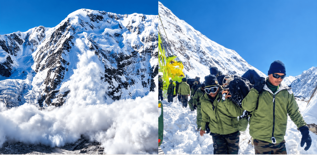
Identify the disaster and make a list of disaster-prone areas from India and the world and enlist mitigation measures quoting recent examples.
Avalanches are caused by the sudden instability of snow on steep mountain slopes. Heavy snowfall within a short period adds extra weight to the snowpack, making it unstable, especially when it rests on weak or loosely bonded layers of snow. A sudden rise in temperature can cause partial melting, reducing the friction that holds the snow together. Strong winds may also pile up snow unevenly, creating fragile layers. Natural disturbances, such as earthquakes and vibrations, as well as human activities like skiing, trekking, or construction in mountainous areas, can trigger avalanches by disturbing the balance of the snow-covered slopes.
Prone areas: ...............
Mitigation measures: ...............
Recent examples: ...............
Answer
The disaster is an avalanche.
Prone areas:
- India — the higher Himalayas, especially Jammu and Kashmir (Gulmarg, Sonamarg, the Siachen area), Ladakh, Himachal Pradesh (Lahaul-Spiti, Rohtang, Kinnaur), Uttarakhand (Chamoli, Uttarkashi), Sikkim (Nathu La) and Arunachal Pradesh (Tawang).
- World — the Alps of Switzerland, France, Italy and Austria; the Rocky Mountains of the United States of America and Canada; the Andes of Chile, Argentina and Peru; the Himalaya in Nepal and Pakistan; and the mountains of Japan and Norway.
Mitigation measures:
- Avalanche forecasting and warning bulletins for trekkers, soldiers and villagers.
- Building snow fences, snow bridges and avalanche galleries or snow sheds over roads.
- Controlled blasting to bring down unstable snow before it becomes dangerous.
- Avoiding construction, skiing and trekking on known avalanche paths, and marking such paths on maps.
- Providing avalanche beacons, probes and rescue training to people working in snow-bound areas.
Recent examples:
- The avalanche near Mana village in Chamoli district, Uttarakhand, in February 2025, which buried a road workers’ camp.
- In February 2024, at Gulmarg, Jammu & Kashmir, a large avalanche hit the Gulmarg ski area, killing a skier and trapping others.
- The avalanche at Nathu La in Sikkim in April 2023, which struck a group of tourists.
Identify the disaster and make a list of disaster-prone areas from India and the world and enlist mitigation measures quoting recent examples.
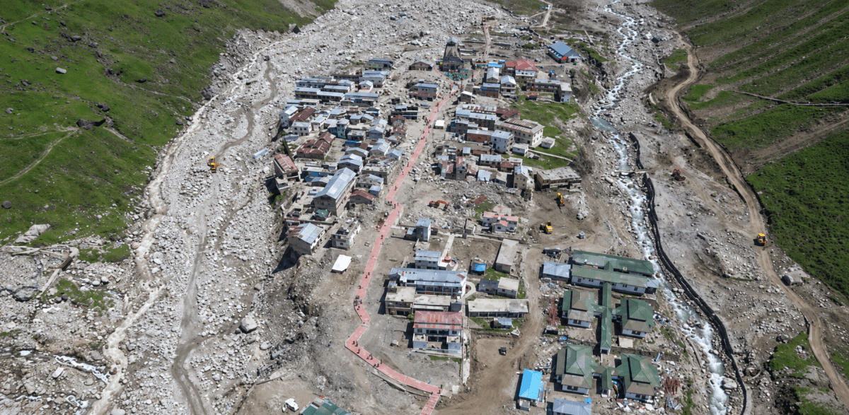
Glacial Lake Outburst Floods (GLOFs) are caused by the sudden release of large volumes of water from glacial lakes due to natural and climatic factors. Rapid melting of glaciers because of rising temperatures increases the size and water level of glacial lakes, putting pressure on their natural dams made of ice or loose moraines. Heavy rainfall or intense snowfall can add excess water to these lakes. Earthquakes, avalanches, or landslides may strike the lake or weaken the dam, leading to its sudden collapse. As a result, the stored water is released abruptly, causing destructive floods in downstream areas.
Prone areas: ...............
Mitigation measures: ...............
Recent examples: ...............
Answer
The disaster is a Glacial Lake Outburst Flood (GLOF).
Prone areas:
- India — the glaciated valleys of Sikkim (the Teesta basin), Uttarakhand (the Alaknanda, Dhauliganga and Bhagirathi valleys), Himachal Pradesh (Lahaul-Spiti, Kinnaur), Ladakh and Arunachal Pradesh.
- World — Nepal, Bhutan, Tibet region of China, Pakistan (Gilgit-Baltistan), Peru, Bolivia, Iceland, Switzerland, Norway, Canada and Alaska in the United States of America.
Mitigation measures:
- Preparing an inventory of glacial lakes and monitoring them regularly through satellite images.
- Lowering the water level of dangerous lakes by making controlled outlet channels.
- Strengthening natural dams to reduce the risk of sudden lake outbursts.
- Installing automatic early warning systems and sirens in the downstream valleys.
- Restricting settlements, hydel projects and construction in the flood path of such valleys.
- Preparing hazard maps and conducting evacuation drills for the villages downstream.
Recent examples:
- The South Lhonak lake outburst in Sikkim in October 2023, which flooded the Teesta valley and damaged the Chungthang dam.
- The Chamoli disaster in Uttarakhand in February 2021, in which a rock and ice mass fell into the valley and caused a sudden flood.
- The Thame village flood in the Everest region of Nepal in August 2024.
Identify the disaster and make a list of disaster-prone areas from India and the world and enlist mitigation measures quoting recent examples.
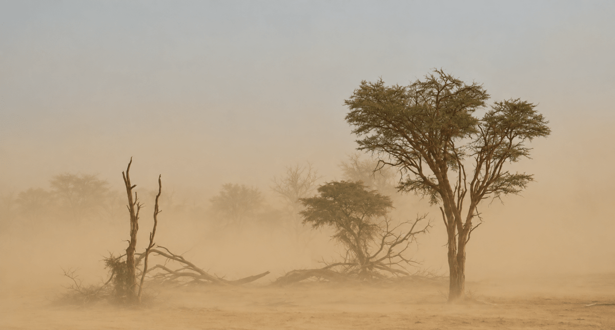
Dust storms are caused by strong winds lifting large amounts of loose, dry soil and sand into the air. Prolonged drought and low rainfall dry out the soil, making it easier for wind to pick up the fine particles. Dust storms are common in desert and semi-arid regions where the soil is loose and dry. Sparse vegetation cover, often due to deforestation, overgrazing, or poor farming practices, also leaves the land exposed. Climate change and extreme weather conditions can further increase the frequency and intensity of dust storms.
Prone areas: ...............
Mitigation measures: ...............
Recent examples: ...............
Answer
The disaster is a dust storm.
Prone areas:
- India — Rajasthan and the Thar desert, Haryana, Punjab, Delhi and the National Capital Region, western Uttar Pradesh, the Kachchh region of Gujarat and western Madhya Pradesh.
- World — the Sahara desert of North Africa, the Arabian peninsula, Iraq and Iran, the Gobi desert of Mongolia and China, the deserts of Central Asia, the south-western United States of America and inland Australia.
Mitigation measures:
- Planting shelter-belts and windbreaks of trees along the edges of fields and roads.
- Afforestation and grass cover to hold the loose soil in place.
- Checking overgrazing and deforestation, and stabilising sand dunes with vegetation.
- Practising contour ploughing, mulching and stubble mulching so that the soil is not left bare.
- Issuing dust storm forecasts and air-quality warnings, and advising people to stay indoors and use masks.
- Improving irrigation and moisture conservation in dry regions.
Recent examples:
- A massive dust storm swept across Churu, Rajasthan with thick dust clouds reducing visibility to near zero in May 2026.
- Severe dust storms affected Delhi and the National Capital Region in May 2025.
- A significant dust storm was recorded in Ahmedabad, Gujarat, in May 2024.
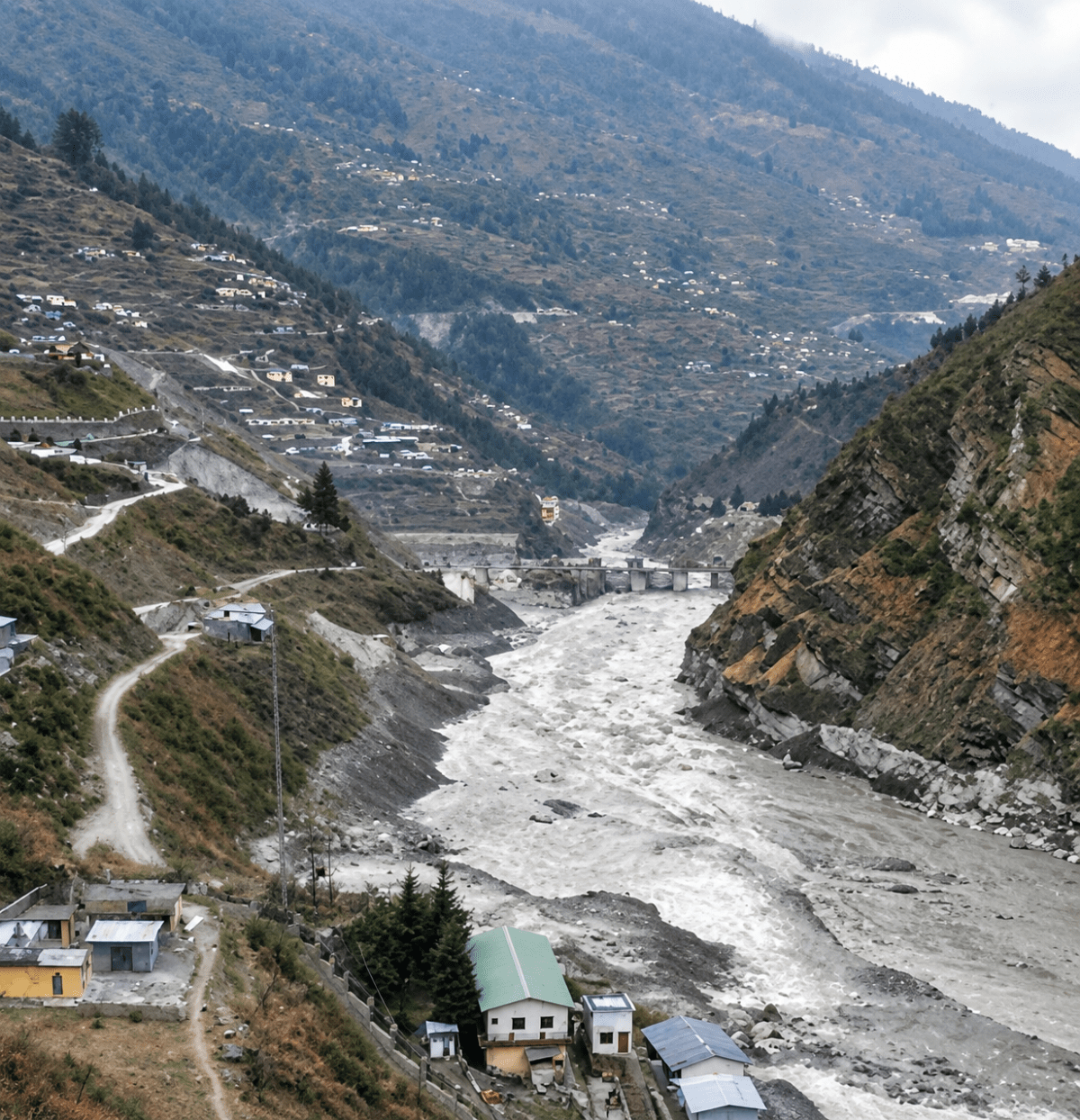
A devastating flood struck the Chamoli district in Uttarakhand in February 2021 in which many people and livestock lost their lives. There was severe damage to buildings, roads, bridges, and hydel projects, and connectivity to villages was adversely affected. Can you find out the reasons that led to the sudden and unexpected flood?
Answer
The reasons that led to the sudden and unexpected flood were:
- A huge mass of rock and glacier ice collapsed from the mountain and rushed down towards the Rishiganga valley.
- As it moved downhill, the mass broke apart and mixed with rock, sediment and water.
- It developed into a fast-moving debris flow that travelled through the Rishiganga and Dhauliganga valleys.
- The steep relief of the Himalayan valley increased the speed and destructive force of the flow.
- The debris flow struck hydropower projects, roads, bridges and settlements downstream, causing extensive loss of life and property.
Thus, the disaster was a sudden rock-and-ice avalanche followed by a destructive debris flow and flood.
What are the sources of energy that are required to cause movements associated with the internal forces of the Earth?
Answer
- The main source of energy is the heat of the Earth’s interior.
- This internal heat sets up convection currents in the mantle: hotter material rises while cooler material sinks.
- These convection currents push and pull the tectonic plates, causing them to move in different directions.
- Plate movement produces stress and pressure in the crust, leading to processes such as earthquakes, volcanic activity, folding and faulting.
Relate various physiographic divisions you have studied in the earlier grades with various endogenic forces responsible for their origin.
Answer
| Sn. No. | Physiographic division | Endogenic force responsible for its origin |
|---|---|---|
| 1. | The Himalayan Mountains | Formed by folding when the Indo-Australian Plate collided with the Eurasian Plate along a convergent boundary. They are young fold mountains and the collision still continues, which is the region for frequent earthquakes in that region. |
| 2. | The Northern Plains | The collision of the two plates created a deep trough between the rising Himalaya and the old Peninsular block. Subsidence of this trough is the endogenic cause; it was later filled with alluvium brought by the rivers. |
| 3. | The Peninsular Plateau | An ancient and stable landmass formed by the breaking up and drifting away of Gondwana land. The Deccan trap portion was formed by vast outpourings of lava through fissure volcanic eruptions. |
| 4. | The Western Ghats and the Aravalli Hills | The Western Ghats mark the faulted western edge of the Deccan plateau formed when the block to its west subsided. The Aravalli is one of the oldest fold mountain ranges, now worn down to hills. |
| 5. | The Coastal Plains | The western coast is a faulted coast formed by subsidence of the land. |
| 6. | The Islands | The Andaman and Nicobar Islands are the elevated portions of submarine mountains raised along a convergent plate boundary, where volcanic activity is still seen, as at Barren Island. The Lakshadweep Islands are of coral origin built on submerged volcanic platforms. |
Why and where do earthquakes occur frequently? Is it possible to predict earthquakes?
Answer
Why they occur — Earthquakes occur because tectonic plates constantly move over the semi-molten asthenosphere. As plates collide, pull apart, or slide past one another, massive stress builds up in the rocks along the boundaries until they break, releasing energy as vibrations through the crust. These vibrations are felt as an earthquake.
Where they occur frequently — Earthquakes occur most frequently along the plate boundaries:
- Around the margins of the Pacific Ocean, the belt called the Ring of Fire.
- Along the convergent boundary of the Indo-Australian and Eurasian plates, that is, along the Himalaya and the mountain belt extending westward.
- Along the mid-ocean ridges, such as the Mid-Atlantic Ridge, which are divergent boundaries.
- Along transform boundaries such as the San Andreas Fault in the United States of America.
Can they be predicted? — No, with present-day scientific knowledge, the exact time, place and magnitude of an earthquake cannot be predicted. Plate tectonics helps identify earthquake-prone regions and assess hazards. In ancient India, Varāhamihira’s Bṛihatsaṁhitā described natural and celestial phenomena as possible signs of earthquakes, but these are not scientifically reliable predictors today. Therefore, emphasis is placed on preparedness, including earthquake-resistant buildings, mock drills and disaster-management plans.
“Plate movements are responsible for the distribution of earthquakes and volcanoes.” Explain.
Answer
Volcanoes and earthquakes are not randomly distributed, they line up along plate boundaries where crustal movements take place:
- Convergent boundaries — Plates push together, forming fold mountains (such as the Himalayas) and forcing heavier oceanic plates into the hot mantle, where melting rock rises as magma to feed volcanoes while triggering deep earthquakes.
- Divergent boundaries — Plates pull apart, allowing magma to rise, cool and solidify into new crust, forming volcanic underwater ridges (e.g., the Mid-Atlantic Ridge) and shallow earthquakes.
- Transform boundaries — Plates scrape past each other, causing strong surface earthquakes along fault lines, such as those along the San Andreas Fault in the United States of America.
- Evidence from the maps — When the map of plates (Fig. 2.3) is compared with the map of earthquakes and volcanoes (Fig. 2.4), the two patterns match. Most earthquakes and volcanoes occur along plate boundaries, especially around the Pacific Ocean, in the belt known as the Ring of Fire, while the interiors of the plates are largely free of them.
Draw and label a diagram of a meander and a delta.
Answer
Meander — A meander is a winding curve or bend in the middle or lower course of a river, formed due to the lateral erosion and deposition of sediments. As the river flows, it erodes the outer banks of the bends and deposits sediment on the inner banks, gradually creating large loops.
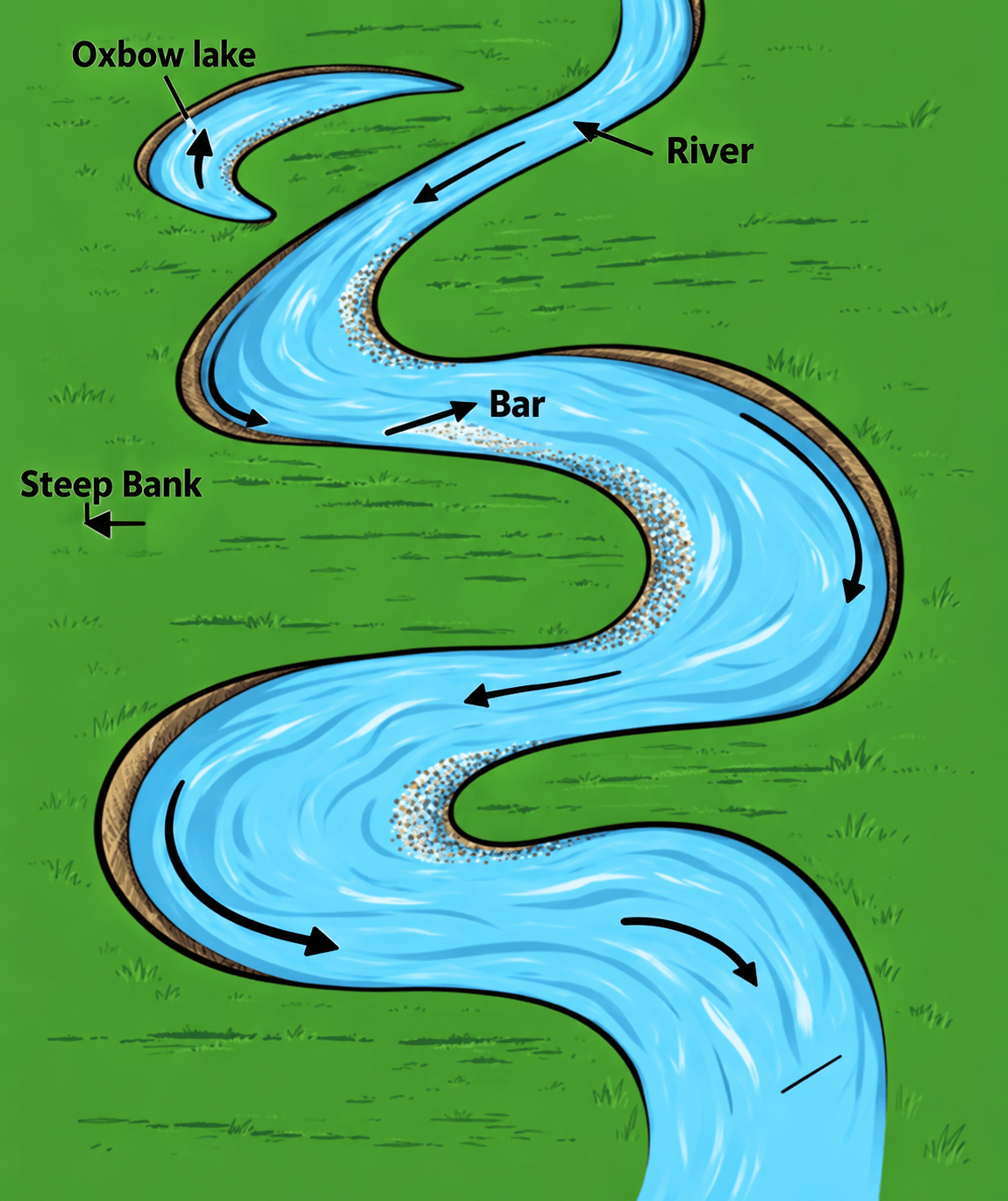
Labels — 1. Oxbow lake 2. Steep bank 3. River 4. Bar
Delta — A delta is a landform formed at the mouth of a river, where it flows into a sea, ocean or lake, and deposits the sediments it has carried from upstream. Over time these deposits accumulate to form a fan-shaped or triangular area of land.
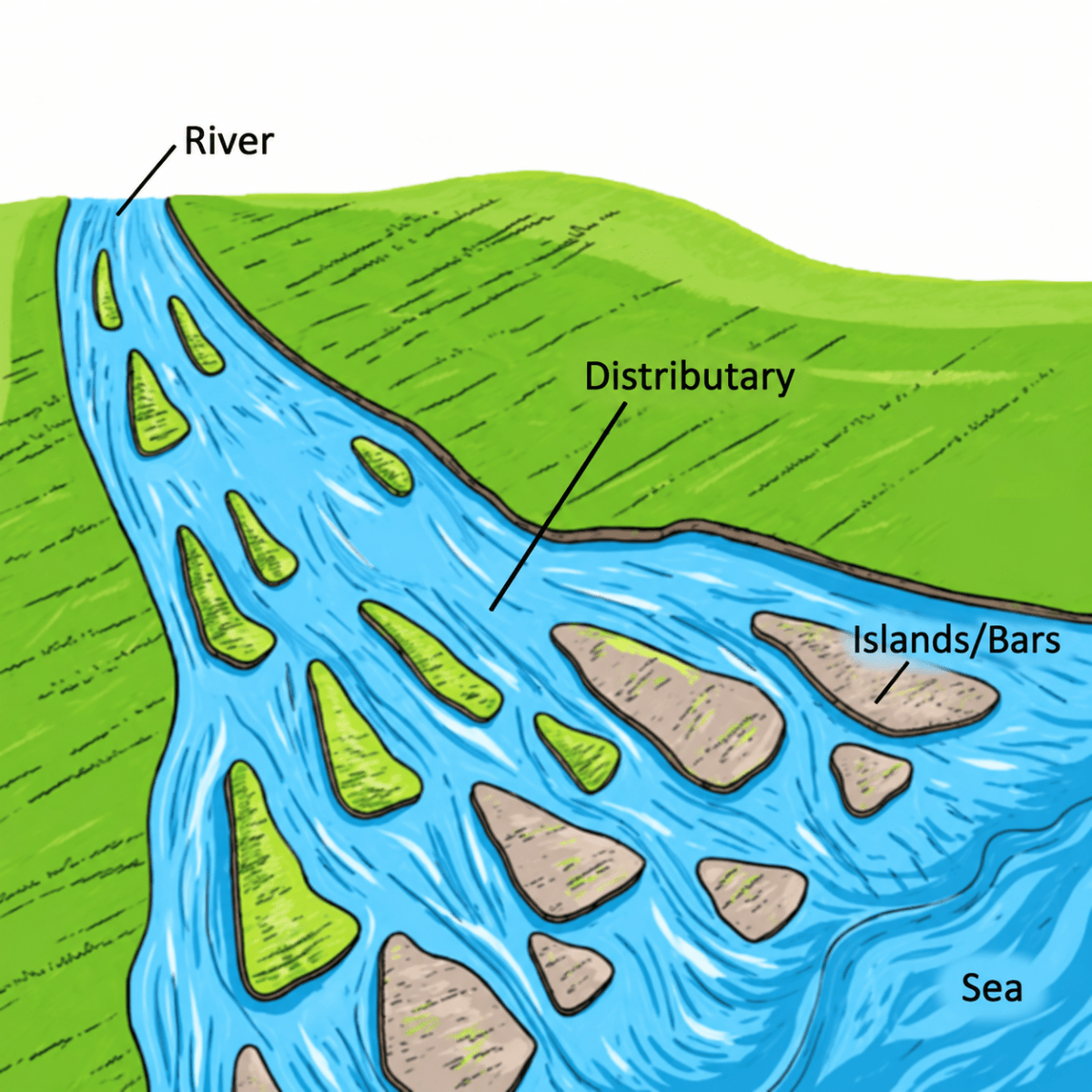
Labels — 1. River 2. Distributary 3. Islands/Bars 4. Sea
How are deforestation and erosion associated with each other? Explain.
Answer
Deforestation and erosion are closely connected, and each one makes the other worse.
- Forests protect the soil — The leaves and branches of trees break the force of the falling raindrops, and the roots of the trees and grasses bind the soil particles firmly together. Forests also slow down the surface run-off so that water sinks into the ground instead of flowing away.
- Deforestation exposes the soil — Cutting down forests leaves the soil bare. Rain washes away fertile topsoil and forms rills and gullies, while in dry regions, sparse vegetation allows wind to lift loose soil and cause dust storms.
- Deforestation triggers other forms of erosion — On hill slopes, deforestation is one of the human activities that disturbs the natural balance of the slope and leads to landslides, in which large amounts of material are removed at once.
- Erosion prevents the forest from returning — Once the fertile topsoil has been removed, seeds cannot germinate and plants cannot grow well on the remaining infertile subsoil. So the forest cannot grow back, and the land goes on being eroded.
Develop a plan to protect the land in your local area from erosion.
Answer
A plan to protect the land of the local area from erosion may include the following steps:
- Survey the area — Identify bare slopes, gullies, eroding stream banks and areas near construction sites.
- Increase plant cover — Plant trees and grasses to bind the soil and use shelterbelts to reduce wind erosion.
- Treat slopes — Practise terracing and contour bunding to slow surface run-off.
- Conserve water — Use contour trenches and check dams to slow run-off, reduce erosion and conserve soil moisture.
- Improve farming practices — Use contour ploughing, crop rotation, mulching and cover crops, and avoid overgrazing.
- Regulate human activities — Control quarrying, mining, brick-making and unplanned construction, and provide proper drainage.
- Involve the community — Create awareness and encourage people to maintain soil-conservation measures.
Which disasters do you think you might experience in your region? Discuss a mitigation plan in your classroom.
Answer
India faces several natural disasters due to its varied physical features.
Common Disasters
- Floods: Heavy monsoon rainfall and river overflow affect plains and delta regions.
- Cyclones and storm surges: Coastal areas face strong winds, heavy rain and coastal flooding.
- Earthquakes: The Himalayan region and other fault zones experience destructive ground shaking.
- Landslides: Heavy rainfall can trigger landslides in hilly and mountainous areas.
- Droughts and dust storms: Arid and semi-arid regions face water shortages, dry soil and wind erosion.
Mitigation plan:
- Construct earthquake-resistant buildings, embankments, check dams, retaining walls and proper drainage systems.
- Promote afforestation, shelter belts and mangrove plantations to reduce erosion and protect vulnerable areas.
- Restrict construction on steep slopes, floodplains and other hazard-prone areas.
- Use weather monitoring, satellite data and local warning systems to alert communities.
- Conduct evacuation drills and provide designated shelters with food, water and medical supplies.
Prepare a model of landforms created by underground water.
Answer
A model of landforms created by underground water can be prepared as follows:
- Materials required: Cardboard or thermocol sheet, clay or plaster of Paris, paints, glue, small pebbles, blue paper and labels.
- Prepare the base: Make a raised limestone area using clay or plaster of Paris and fix it on the base.
- Make a cave: Create a hollow space inside the model and leave an opening to show the cave mouth.
- Show stalactites and stalagmites: Fix cone-shaped pieces hanging from the roof of the cave as stalactites and cone-shaped pieces rising from the floor as stalagmites. Join one pair to form a pillar.
- Make sinkholes: Create a few bowl-shaped depressions on the surface to represent sinkholes.
- Show an underground river: Use blue paper or blue paint to depict an underground river flowing through the cave.
- Labelling: Label the cave, cave mouth, stalactites, stalagmites, pillar, sinkholes and underground river.
What precautionary measures will you take if you are staying in an earthquake-prone region?
Answer
Before an earthquake:
- Build the house according to earthquake-resistant designs and building bye-laws, and repair weak walls and roofs.
- Fasten heavy furniture, cupboards, shelves, mirrors and geysers securely to the walls, and keep heavy objects on lower shelves.
- Keep an emergency kit ready containing a torch, batteries, drinking water, dry food, a first-aid box, medicines, a whistle and copies of important documents.
- Learn to switch off the electricity mains and the gas supply, and keep the exits and passages free of clutter.
- Take part in mock drills at school and at home, and fix a common meeting place for the family.
During an earthquake:
- If indoors, drop down, take cover under a strong table or against an inner wall, and hold on until the shaking stops. Stay away from windows, glass and heavy furniture.
- If outdoors, move to an open space away from buildings, trees, walls and electric poles.
- Do not use lifts, and do not rush towards staircases in panic.
After an earthquake:
- Come out calmly, check for injuries and give first aid, and be prepared for aftershocks.
- Do not enter damaged buildings, do not touch fallen electric wires, and listen to official announcements on the radio or television.
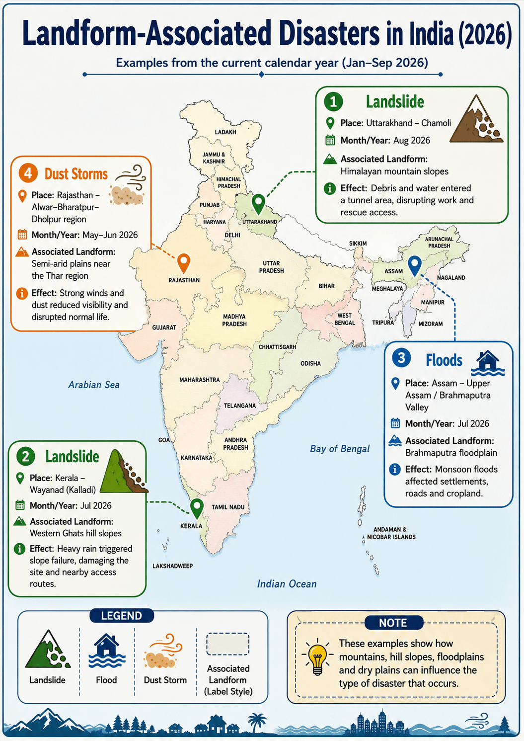
Prepare a map showing landform-associated disasters that happened in the current calendar year.
Answer
A map showing landform-associated disasters that occurred in the current calendar year is shown below.
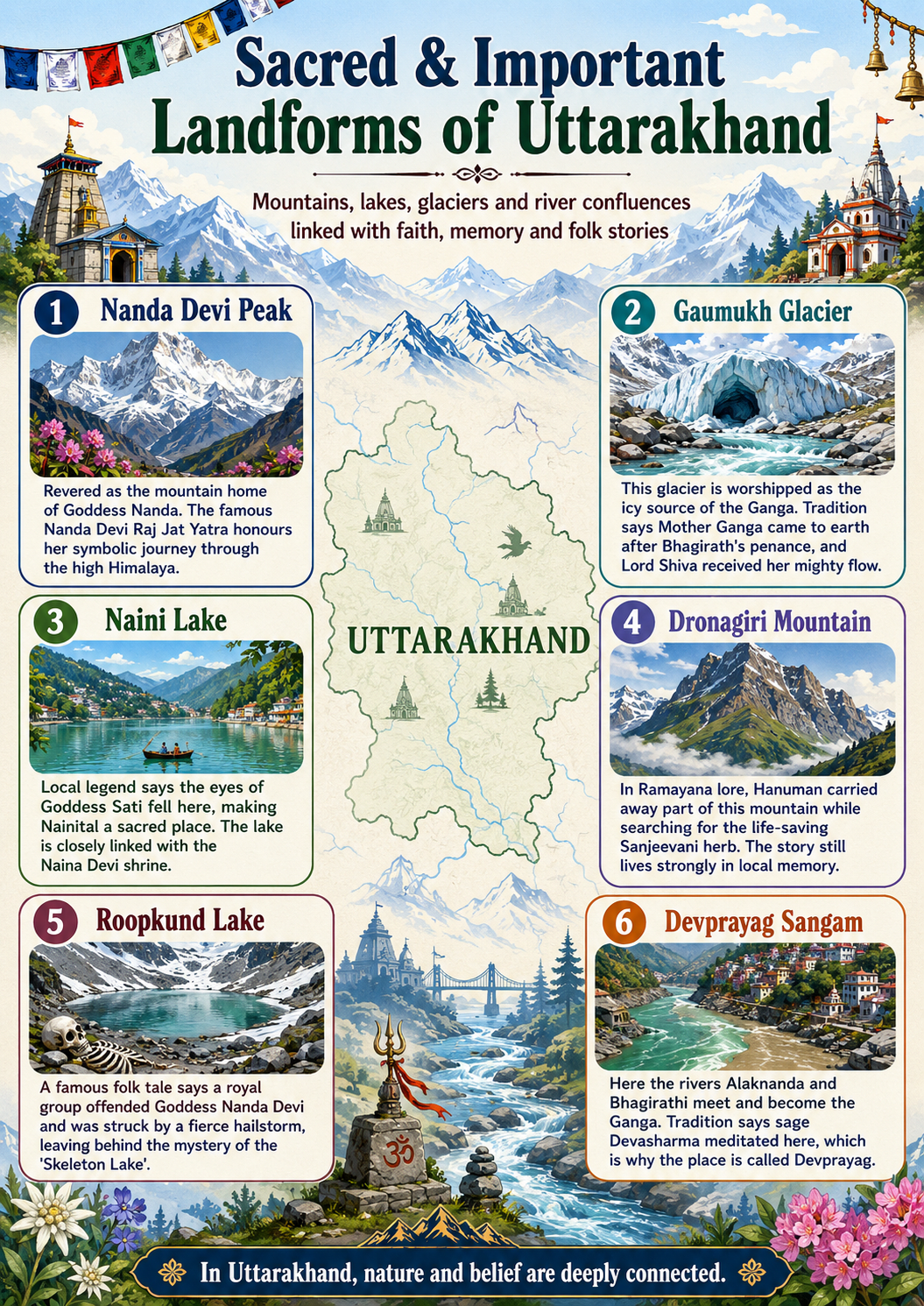
Create a poster showing landforms that are considered to be sacred or important in your region, and add the folk stories associated with them.
Answer
The poster showing landforms that are considered sacred in Uttarakhand is shown below.
Document a case of a disaster that hit your region in the past, highlighting its effects on various human activities.
Answer
Name and type of the disaster — Wayanad Landslides, 2024, a series of landslides and debris flows associated with the steep hill slopes of the Western Ghats.
Place and date — The landslides occurred on 30 July 2024 in Wayanad district, Kerala. Mundakkai and Chooralmala were among the worst-affected areas.
Causes — Continuous and exceptionally heavy monsoon rainfall saturated the soil and made the steep slopes unstable, triggering the landslides. The hilly terrain and loose weathered material increased the risk. Human settlement and development in landslide-prone areas increased the number of people and properties exposed to the disaster.
Effects on human activities:
i. Agriculture — Plantations and farmland were buried under mud, rocks and debris. Crops and livestock were lost, affecting farmers' incomes.
ii. Settlement — Many houses were destroyed or badly damaged. Thousands of people were displaced and had to move to relief camps or safer places.
iii. Transport and communication — Roads and bridges were damaged, cutting off affected villages and making rescue operations difficult. A temporary Bailey bridge was brought in to restore connectivity.
iv. Trade and industry — Shops, small businesses, plantations and local services stopped functioning, causing loss of employment and income.
v. Tourism — Tourism declined because roads and tourist areas became unsafe or inaccessible.
vi. Health and education — Many people were injured and required medical care. Displacement and damage to infrastructure also disrupted children's education and normal community life.