
The capital city of Australia.
- Sydney
- Melbourne
- Canberra
- Perth
Answer
Canberra
Reason — Canberra is the national capital of Australia. Sydney is the largest city and the capital of New South Wales, Melbourne is the capital of Victoria, and Perth is a major industrial town in Western Australia — none of these is the national capital.
The only water rich zone of Australia, where water gushes out on its own and is not required to be pumped out.
- permeable rocks
- the Central Lowlands
- the Great Artesian Basin
- the Western Plateau
Answer
the Great Artesian Basin
Reason — In the Great Artesian Basin, wells are bored in the ground from where groundwater rushes out automatically due to high water pressure, so it does not need to be pumped out. Permeable rocks, the Central Lowlands and the Western Plateau do not have this self-flowing supply of water.
Jackaroos work in the sheep station. But this is not their job.
- shearing sheep
- guarding sheep
- growing maize
- cleaning fleece
Answer
growing maize
Reason — Jackaroos look after and guard the sheep on a sheep station, and the station's wool activities also include shearing the sheep and cleaning the fleece. Growing maize is an agricultural activity and is not connected with their work on a sheep station.
Match the cities given in List I correctly with the states of Australia given in List II.
| List I | List II |
|---|---|
| A. Hobart | 1. Western Australia |
| B. Darwin | 2. South Australia |
| C. Perth | 3. Northern Territory |
| D. Adelaide | 4. Tasmania |
- A-4, B-3, C-1, D-2
- A-2, B-1, C-3, D-4
- A-2, B-3, C-4, D-1
- A-4, B-1, C-2, D-3
Answer
A-4, B-3, C-1, D-2
Reason — Hobart is the capital of Tasmania (A-4), Darwin is the capital of the Northern Territory (B-3), Perth is the capital of Western Australia (C-1), and Adelaide is the capital of South Australia (D-2).
Which of the following straits separate Australia from New Guinea Island?
- the Bering Strait
- the Palk Strait
- the Cook Strait
- the Torres Strait
Answer
the Torres Strait
Reason — The Torres Strait separates Australia from New Guinea Island in the north. The Bering Strait, the Palk Strait and the Cook Strait lie elsewhere and do not separate Australia from New Guinea Island.
Match Column A with Column B.
| Column A – State | Column B – Capital |
|---|---|
| A. New South Wales | 1. Melbourne |
| B. Victoria | 2. Hobart |
| C. Tasmania | 3. Sydney |
| D. Northern Territory | 4. Darwin |
- A-2, B-3, C-4, D-1
- A-3, B-1, C-2, D-4
- A-4, B-3, C-2, D-1
- A-1, B-2, C-3, D-4
Answer
A-3, B-1, C-2, D-4
Reason — Sydney is the capital of New South Wales (A-3), Melbourne is the capital of Victoria (B-1), Hobart is the capital of Tasmania (C-2), and Darwin is the capital of the Northern Territory (D-4).
Complete the relationship.
Queensland : Brisbane : : Western Australia : ...........
- Adelaide
- Canberra
- Perth
- Griffith
Answer
Perth
Reason — Just as Brisbane is the capital of Queensland, Perth is the capital of Western Australia. Adelaide is the capital of South Australia, Canberra is the national capital of Australia, and Griffith is not a capital city.
What is the extension of the Great Dividing Range of Australia?
- Queensland to Tasmania
- Eastern Highlands to Central Lowland
- Victoria to Queensland
- South Australia to Northern Territory
Answer
Queensland to Tasmania
Reason — The Great Dividing Range extends from the Cape York Peninsula, located in the northeastern state of Queensland, to Tasmania. It does not run from the Eastern Highlands to the Central Lowland, from Victoria to Queensland, or from South Australia to the Northern Territory.
What does the Great Artesian Basin have at its base?
- granite
- basalt
- sandstone
- marble
Answer
sandstone
Reason — The Great Artesian Basin is formed on a base of sandstone, covered by a layer of marine sedimentary rock. Granite, basalt and marble are not mentioned as the base of the basin.
Where is the rift valley located in Australia?
- in northern Australia
- in eastern Australia
- in western Australia
- in southern Australia
Answer
in southern Australia
Reason — The rift valley of Australia is located in the southern part of the continent, where it has several lakes such as Lake Torrens. It is not located in northern, eastern or western Australia.
What is the name of the best breed of sheep reared in Australia?
- Lincoln
- Merino
- Marsh
- Romney
Answer
Merino
Reason — Merino is the best breed of sheep reared in Australia for producing high-grade wool. About 70 per cent of Australia's sheep are of the Merino breed.
Australia is the world's largest exporter of which of the following products?
- cotton
- wool
- jute
- silk
Answer
wool
Reason — Australia is the world's largest exporter of wool; it has one-seventh of the world's sheep and produces one-fourth of the world's wool. It is not the world's largest exporter of cotton, jute or silk.
Assertion (A): Sheep farming in Australia is extensive in nature.
Reason (R): Australia has one-seventh of the world's sheep and produces one-fourth of the world's wool.
- A is true, but R is false.
- A is false, but R is true.
- Both A and R are true, but R is not the correct explanation of A.
- Both A and R are true, and R is the correct explanation of A.
Answer
Both A and R are true, but R is not the correct explanation of A.
Explanation — Sheep farming in Australia is extensive in nature because in the dry interiors, large pastoral zones exist where sheep are spread over vast areas. Australia does have one-seventh of the world's sheep and produces one-fourth of the world's wool, but this describes the quantity of sheep and wool, not the reason the farming is extensive. Hence R is true but does not correctly explain A.
Assertion (A): The population in Australia is unevenly distributed.
Reason (R): Population is mainly concentrated in parts of eastern and southeastern coasts.
- A is true, but R is false.
- A is false, but R is true.
- Both A and R are true, but R is not the correct explanation of A.
- Both A and R are true, and R is the correct explanation of A.
Answer
Both A and R are true, and R is the correct explanation of A.
Explanation — The population of Australia is unevenly distributed because two-thirds of the continent is a desert. The population is mainly concentrated in parts of the eastern and southeastern coasts, and this uneven concentration is exactly what makes the distribution uneven. Hence R correctly explains A.
Assertion (A): The Western Plateau receives scanty rainfall.
Reason (R): There are vast desert areas in this region.
- A is true, but R is false.
- A is false, but R is true.
- Both A and R are true, but R is not the correct explanation of A.
- Both A and R are true, and R is the correct explanation of A.
Answer
Both A and R are true, but R is not the correct explanation of A.
Explanation — The Western Plateau does receive scanty rainfall, and there are vast desert areas in this region. However, it is the scanty rainfall that has led to the occurrence of the deserts — the deserts are the result of the scanty rainfall, not its cause. Hence R does not correctly explain A.
Assertion (A): Sheep farming in Australia is usually extensive in nature.
Reason (R): In humid regions, most of the land is used for arable farming.
- A is true, but R is false.
- A is false, but R is true.
- Both A and R are true, but R is not the correct explanation of A.
- Both A and R are true, and R is the correct explanation of A.
Answer
Both A and R are true, but R is not the correct explanation of A.
Explanation — Sheep farming in Australia is usually extensive in nature because in the dry interiors extensive pastoral zones exist, unlike the humid coastal areas where sheep farms are small in size. It is also true that in humid regions most of the land is used for arable farming. However, the extensive nature of sheep farming is due to the large pastoral zones of the dry interiors, so R does not correctly explain A.
Give reason — Australia is the world's only continent that is also a country.
Answer
Australia is the world's only continent that is also a country because the entire Australian continent forms a single nation. It is referred to as an island continent as water bodies surround it on all sides — the Indian Ocean on its west and south, and the Pacific Ocean on its east and north. In terms of area, it is the smallest continent and the sixth largest country in the world.
Give reason — The Great Artesian Basin is the major source of water in relatively dry areas of Australia.
Answer
The Great Artesian Basin is the major source of water in this relatively dry area because wells are bored in the ground, from where groundwater rushes out automatically. Due to the high water pressure, the water does not need to be pumped out. This water is very useful for the cattle rearers in this dry region.
Define the following terms:
a. coral polyps
b. paddock
c. jackaroo
Answer
a. Coral polyps — Coral polyps are small marine organisms that live in shallow, warm tropical oceans, and whose skeletal remains form coral reefs such as the Great Barrier Reef.
b. Paddock — A paddock is one of the separate fenced enclosures into which a sheep station is divided; each paddock has about 2,000 to 3,000 sheep.
c. Jackaroo — A jackaroo is a paid worker employed in a sheep station to look after the animals, moving them from one paddock to another, treating them for illness and injuries, and protecting them from wild animals.
Why is Australia called an island continent?
Answer
Australia is called an island continent because it is a continent that is surrounded by water bodies on all sides — the Indian Ocean lies to its west and south, while the Pacific Ocean lies to its east and north. In terms of area, it is the smallest continent and the sixth largest country in the world.
Who was James Cook?
Answer
James Cook was the captain of an English expedition who landed on the east coast of Australia in 1770 and found the land suitable for habitation.
Name the six physical divisions of Australia.
Answer
The six physical divisions of Australia are:
- the Western Plateau
- the Central Lowland
- the Eastern Highlands
- the Great Artesian Basin
- the Great Barrier Reef
- the Rift Valley of Australia
Write three sentences about the Great Artesian Basin.
Answer
- The Great Artesian Basin lies between the Eastern Highlands and the Central Lowland, and is one of the largest and deepest artesian basins in the world, covering about one-fifth of the Australian continent.
- It is formed on a base of sandstone, covered by a layer of marine sedimentary rock.
- It is the major source of water in this relatively dry area — wells are bored in the ground from where groundwater rushes out automatically due to high water pressure, without needing to be pumped out.
Where is the Great Barrier Reef located?
Answer
The Great Barrier Reef is located on the north-eastern coast of Australia. It is the world's largest coral reef.
What is a sheep station?
Answer
A sheep station is a large sheep farm covering thousands of hectares where sheep are reared. It is divided by fences into a number of fields called paddocks. A sheep station has homesteads for the family and workers, sheds for shearing and storing wool, wells or a dam to provide water, windmills for energy, silos for storing grain, a landing strip for light aircraft or helicopters, and shops that sell essential commodities.
Distinguish between — Western Plateau and Central Lowland.
Answer
| Western Plateau | Central Lowland |
|---|---|
| It covers one-third of the continent. | It extends from the Gulf of Carpentaria in the north to the southern coast of the continent. |
| It comprises very old, hard rocks and has an undulating surface with an average height of about 360 m above sea level. | It is a low-lying region that contains Lake Eyre, the lowest point on the continent, about 15 m below sea level. |
| It receives scanty rainfall, which has led to vast desert areas such as the Great Victoria Desert, the Great Sandy Desert and the Gibson Desert. | It contains two major drainage basins — the Murray-Darling Basin and the Eyre Basin. Several rivers flow into Lake Eyre instead of reaching the sea, forming an inland drainage system. |
| Its important relief features include the Hamersley Range, Musgrave Range and Barkly Tableland. | Its northern part is drained by north-flowing rivers such as the Flinders. |
Distinguish between — a sheep station and paddock.
Answer
| Sheep station | Paddock |
|---|---|
| A sheep station is a large sheep farm covering thousands of hectares. | A paddock is one of the fields into which a sheep station is divided by fences. |
| It has homesteads, sheds, wells or a dam, windmills, silos, a landing strip and shops. | It is a smaller fenced enclosure within the sheep station. |
| A whole sheep station may run into thousands of hectares. | A paddock has about 2,000 to 3,000 sheep. |
This is a picture of Ayers Rock. Look at the given picture and answer the following questions.
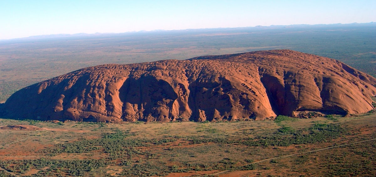
a. What is the other name that this land feature is also known by?
b. Where in Australia is this land feature located?
c. What kind of a physical feature is it?
Answer
a. Ayers Rock is also known by the name Uluru. In the Aboriginal language, it means 'the place where the wind moans between sunset and dawn'.
b. It is located in the central part of Australia, in the Northern Territory, near the Macdonnell Ranges.
c. It is a spectacular monolithic hill formed of red sandstone. It changes its colour from reddish brown at dawn to yellow during the day, and at times it appears violet too.
Look at the given picture and answer the following questions.
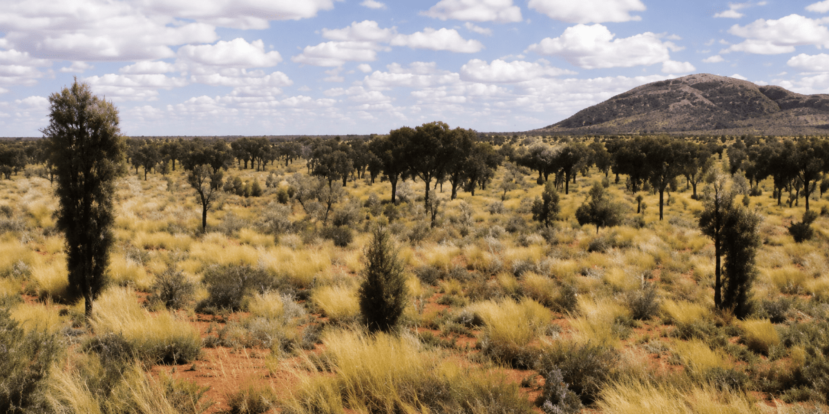
a. How much of Australia's mainland is covered with desert?
b. Name some of the famous deserts of the western plateau region.
Answer
a. Deserts cover about 18 per cent of Australia's mainland.
b. Some of the famous deserts of the western plateau region are the Great Victoria Desert, the Great Sandy Desert and the Gibson Desert.
Life can be hard on the sheep stations of Australia. However, people here have learned to adapt and make the best use of available resources. How is this an example of using the available resources?
Answer
People living on the sheep stations of Australia have adapted to the harsh, dry conditions by making the best use of the limited resources available to them. This is seen in the following ways:
- In the dry interiors where natural grasslands are available, they rear Merino sheep, which give high-grade wool, thus making good use of the grasslands.
- Since water is scarce, they use the water of the Great Artesian Basin by boring wells from which groundwater rushes out on its own. Wells and dams provide water, while windmills provide energy.
- The large sheep stations are divided into paddocks by fences so that the sheep can be managed and moved easily over vast areas.
- As the stations are remote, they use landing strips for light aircraft and helicopters that bring flying doctors and essential commodities.
In this way, despite the hard life, the people here have learned to adapt and make the best possible use of the grasslands, groundwater and other resources around them.