
The African continent mostly consists of a ................
- vast lowland
- high mountain
- large plateau
- deserts
Answer
large plateau
Reason — Africa mostly comprises a stable plateau. Most parts of the continent consist of highlands in the form of plateaus.
The Nile River drains into the ................
- Indian Ocean
- Mediterranean Sea
- Red Sea
- Atlantic Ocean
Answer
Mediterranean Sea
Reason — The Nile flows northwards and drains into the Mediterranean Sea. It does not drain into the Indian Ocean, the Red Sea or the Atlantic Ocean.
This is a coastal desert in the southern part of Africa.
- Kalahari
- Sahara
- Namib
- Arabian
Answer
Namib
Reason — The Namib is a coastal desert in southern Africa that stretches along the Atlantic coasts of Angola, Namibia and South Africa. The Kalahari is a semi-arid inland desert of the south, the Sahara is a hot desert of the north, and the Arabian Desert lies in Asia, not Africa.
The Atlantic Ocean and the Mediterranean Sea are linked by this strait.
- Bering
- Bab-el Mandeb
- Palk
- Gibraltar
Answer
Gibraltar
Reason — The Strait of Gibraltar, between Europe and Africa, links the Mediterranean Sea with the Atlantic Ocean. The Strait of Bab-el-Mandeb separates Africa from Arabia, the Bering Strait separates Asia from North America, and the Palk Strait lies between India and Sri Lanka.
The Suez Canal links the Red Sea to this water body.
- Atlantic Ocean
- Pacific Ocean
- Indian Ocean
- Mediterranean Sea
Answer
Mediterranean Sea
Reason — The Suez Canal has been constructed through the Isthmus of Suez, linking the Red Sea and the Mediterranean Sea. It does not link the Red Sea to the Atlantic, Pacific or Indian Oceans.
Which of the following peninsulas join Africa to Asia?
- the Sinai Peninsula
- the Balkan Peninsula
- the Arabian Peninsula
- the Iberian Peninsula
Answer
the Sinai Peninsula
Reason — In the northeast, the Sinai Peninsula, a small triangular piece of land, joins Africa to Asia. The Balkan and Iberian Peninsulas lie in Europe, and the Arabian Peninsula is part of Asia, so none of them join Africa to Asia.
The Suez Canal has been constructed by linking the ............... and the Mediterranean Sea.
- Caspian Sea
- Red Sea
- Black Sea
- Aral Sea
Answer
Red Sea
Reason — The Suez Canal has been constructed through the Isthmus of Suez, linking the Red Sea and the Mediterranean Sea. The Caspian Sea, Black Sea and Aral Sea are not connected to the Mediterranean by the Suez Canal.
Complete the relationship.
The State of Libya : ............... : : The United Republic of Tanzania : Dodoma
- Juba
- Bamako
- Tripoli
- Abuja
Answer
Tripoli
Reason — Just as Dodoma is the capital of the United Republic of Tanzania, Tripoli is the capital of the State of Libya. Juba is the capital of South Sudan, Bamako of Mali and Abuja of Nigeria.
Which of the following lakes, located in Africa, is the second deepest lake in the world after Lake Baikal of Russia?
- Lake Tanganyika
- Lake Titicaca
- Lake Victoria
- Lake Michigan
Answer
Lake Tanganyika
Reason — Lake Tanganyika is the second deepest lake in the world after Lake Baikal of Russia. Lake Victoria, though the largest lake in Africa, is not the deepest, while Lake Titicaca (South America) and Lake Michigan (North America) are not located in Africa.
Which of the following is the highest peak of Africa?
- Mt Kenya
- Mt Elgon
- Mt Kilimanjaro
- Mt Kilo
Answer
Mt Kilimanjaro
Reason — Mt Kilimanjaro, whose central cone Kibo rises to 5,895 metres, is the highest peak in Africa. Mt Kenya (5,199 m) and Mt Elgon are other volcanic mountains north of Lake Victoria but are lower, and there is no notable peak called Mt Kilo.
Which of the African desert is one of the oldest deserts in the world?
- the Sahara Desert
- the Namib Desert
- the Kalahari Desert
- the Arabian Desert
Answer
the Namib Desert
Reason — The Namib, a coastal desert of southern Africa, is one of the oldest deserts in the world. The Sahara is the world's largest hot desert, the Kalahari is a semi-arid desert, and the Arabian Desert is not located in Africa.
The Victoria forms a natural boundary between Zambia and Zimbabwe. On which river does it fall?
- the Nile River
- the Orange River
- the Zambezi River
- the Niger River
Answer
the Zambezi River
Reason — The Victoria Falls lies on the River Zambezi and forms a natural boundary between Zambia and Zimbabwe.
Choose the problems faced in cocoa production in Ghana.
- productive old trees
- large land size
- diseases in the cocoa trees
- high prices of cocoa
Answer
diseases in the cocoa trees
Reason — Diseases in the cocoa trees were one of the problems that led to a decline in cocoa production in Ghana. The other options are the opposite of the actual problems: the old trees were less productive (not productive), the land size was small (not large), and the prices of cocoa set by the government were too low (not high).
Assertion (A): The most striking feature of Africa is the Great Rift Valley in East Africa.
Reason (R): Rainwater fills up the floor of the rift valley to form narrow lakes.
- A is true, but R is false.
- A is false, but R is true.
- Both A and R are true, but R is not the correct explanation of A.
- Both A and R are true, and R is the correct explanation of A.
Answer
Both A and R are true, but R is not the correct explanation of A.
Explanation — The most striking feature of the continent is indeed the Great Rift Valley in East Africa, so A is true. It is also true that rainwater fills up the floor of the rift valley to form narrow lakes, so R is true. However, R merely describes what happens within the rift valley and does not explain why the Great Rift Valley is the most striking feature of Africa, so R is not the correct explanation of A.
Assertion (A): The Kalahari Desert is located in the southern part of Africa.
Reason (R): The Kalahari Desert is a semi-arid desert.
- A is true, but R is false.
- A is false, but R is true.
- Both A and R are true, but R is not the correct explanation of A.
- Both A and R are true, and R is the correct explanation of A.
Answer
Both A and R are true, but R is not the correct explanation of A.
Explanation — The Kalahari Desert is located in the southern part of the continent, so A is true. It is also a semi-arid desert, so R is true. However, being semi-arid does not explain why it is located in southern Africa; the two are unrelated facts, so R is not the correct explanation of A.
Assertion (A): Cocoa trees are grown in large plantation farms.
Reason (R): To protect the plants from direct sunlight, banana trees are often planted in between to provide shade.
- A is true, but R is false.
- A is false, but R is true.
- Both A and R are true, but R is not the correct explanation of A.
- Both A and R are true, and R is the correct explanation of A.
Answer
Both A and R are true, but R is not the correct explanation of A.
Explanation — Cocoa trees are grown in large plantation farms where the trees are planted close to each other, so A is true. It is also true that banana trees are often planted in between to protect the cocoa plants from direct sunlight, so R is true. However, R explains why banana trees are planted, not why cocoa is grown in large plantation farms, so R is not the correct explanation of A.
Give reason — Several European nations tried to colonise the countries of Africa.
Answer
It was the discovery of diamonds in the continent in the 19th century that attracted European colonisers to exploit the wealth of this huge continent. Africa is known for its strategic location and the presence of rich biodiversity and natural resources, and the Europeans wanted to exploit these resources to serve their own interest.
Give reason — Africa is not an island in spite of being surrounded by oceans and seas on most sides.
Answer
Although Africa is surrounded by oceans and seas on most sides, it is not an island because it is linked with the continent of Asia by a narrow strip of land called the Isthmus of Suez. In the northeast, the Sinai Peninsula joins Africa to Asia. Since an island must be completely surrounded by water, and Africa remains connected to Asia by land, it is not an island.
Give reason — Coastal plains are generally absent in the continent.
Answer
Coastal plains are generally absent in the continent because the plateaus rise steeply from the coast. Narrow coastal plains occur only along some parts of the east and west coasts.
Give reason — Despite flowing a long distance through the dry Sahara, the Nile has water throughout the year.
Answer
Even though the Nile flows a long distance through the dry Sahara Desert, it remains a perennial river because it originates from the rainy equatorial region, with its source near Lake Victoria. Being fed by this rainy region, it has water throughout the year.
Give reason — Cocoa farmers in Ghana live in abject poverty.
Answer
The prices of cocoa in the market, set by the government, were too low for the farmers, who suffered a loss. As a result, the people live in abject poverty and child labour is prevalent in most of the farms.
Give reason — Africa was called the Dark Continent.
Answer
Africa was called the Dark Continent because, except for the Mediterranean coast, most parts of Africa were unknown to the rest of the world till as late as the 19th century. This was due to the inaccessibility caused by the presence of the vast Sahara Desert to the north, dense forests and swamps in the central equatorial margins, the prevalence of deadly tropical diseases and the lack of good harbours, which discouraged people from approaching the continent.
Give reason — The Chad Basin forms the largest area of inland drainage.
Answer
The Chad Basin forms the largest area of inland drainage in Africa because several small rivers drain into Lake Chad, which has no outlet to an ocean or sea.
Give reason — Coastal plains are absent from Africa.
Answer
Coastal plains are generally absent from Africa because the plateaus rise steeply from the coast. Narrow coastal plains occur only along some parts of the east and west coasts.
Name the following:
a. The piece of land linking Africa to Asia.
b. The last country in the continent to get independence in 2011.
c. The capital of the Arab Republic of Egypt.
d. The largest lake in Africa.
e. The waterfall on River Zambezi.
f. The longest river in the world.
Answer
a. The Isthmus of Suez
b. South Sudan
c. Cairo
d. Lake Victoria
e. Victoria Falls
f. The Nile
Why was Africa known as the Dark Continent?
Answer
Africa was known as the Dark Continent because, except for the Mediterranean coast, most parts of Africa were unknown to the rest of the world till as late as the 19th century. This was because of the inaccessibility due to the presence of the vast Sahara Desert to the north, dense forests and swamps in the central equatorial margins, the prevalence of deadly tropical diseases, and the lack of good harbours, which discouraged people from approaching the continent.
Name the legendary explorers who explored the African continent.
Answer
David Livingstone and Henry Morton Stanley were two great European explorers of the 19th century who are credited with path-breaking expeditions in certain parts of Africa.
State the approximate latitudinal and longitudinal extent of Africa.
Answer
Africa extends almost equally to the north (37°N) and south (35°S) of the Equator, and stretches from approximately 17°W to 51°E longitude.
Which are the three important latitudes that pass through Africa?
Answer
The three important latitudes that pass through Africa are the Equator, the Tropic of Cancer and the Tropic of Capricorn. Africa is the only continent through which all three of these pass.
Why is the Suez Canal highly significant with respect to trade and commerce?
Answer
The Suez Canal is a sea-level waterway that separates the African continent from Asia. It was built to provide the shortest maritime route between Europe and the countries around the Indian and western Pacific Oceans, and it is one of the world's most heavily used shipping lanes. Prior to its construction, a ship travelling to Asia from Europe had to navigate around the African continent to reach Asia. By providing a much shorter route, the Suez Canal saves time and cost, which makes it highly significant with respect to trade and commerce.
Why is the Chad Basin an area of inland drainage?
Answer
The Chad Basin is an area of inland drainage because several small rivers flow into Lake Chad, which has no outlet to an ocean or sea. It forms the largest area of inland drainage in Africa.
State the extent of the Great Rift Valley. Name some of the lakes that are part of the African Rift Valley system.
Answer
The Great Rift Valley begins near Lake Malawi in the south and extends for more than 6,000 kilometres through the Red Sea to the Dead Sea in southwest Asia.
Some of the lakes that are part of the African Rift Valley system are Lake Malawi, Lake Tanganyika, Lake Kivu and Lake Albert.
Name the two countries that are naturally separated by the Victoria Falls.
Answer
The two countries naturally separated by Victoria Falls are Zambia and Zimbabwe.
What do you understand by the 'cocoa triangle'?
Answer
The greatest concentration of cocoa cultivation in Ghana is in the 'cocoa triangle', which is formed by the towns of Accra, Kumasi and Takoradi.
Explain how cocoa powder is obtained from the cocoa beans.
Answer
Cocoa powder is obtained from cocoa beans through the following steps:
- The cocoa pods are split open.
- The beans, embedded in the pulp, are scooped out.
- The beans are allowed to ferment in heaps covered with banana leaves.
- As the pulp softens, it is removed. The fermented beans are then washed, cleaned and roasted.
- Once the beans are thoroughly dry, they are packed and transported.
- Finally, the beans are crushed to obtain cocoa powder.
How were the problems of cocoa plantation solved to develop a viable economy?
Answer
To deal with the problems of cocoa cultivation, the Cocoa Research Institute of Ghana (CRIG) was set up in 1938. The Ghana Cocoa Board (COCOBOD) was established in 1947 and helped the cocoa industry progress by leaps and bounds. New hybrid varieties of trees were planted to achieve greater productivity. The use of fertilisers, disease and pest control, and scientific research boosted cocoa production. The combined efforts of the farmers, the government—through subsidies on hybrid seeds, fertilisers and pesticides—and COCOBOD helped Ghana regain its number one position in cocoa production and develop a viable economy.
Look at the picture given here and answer the questions given below:
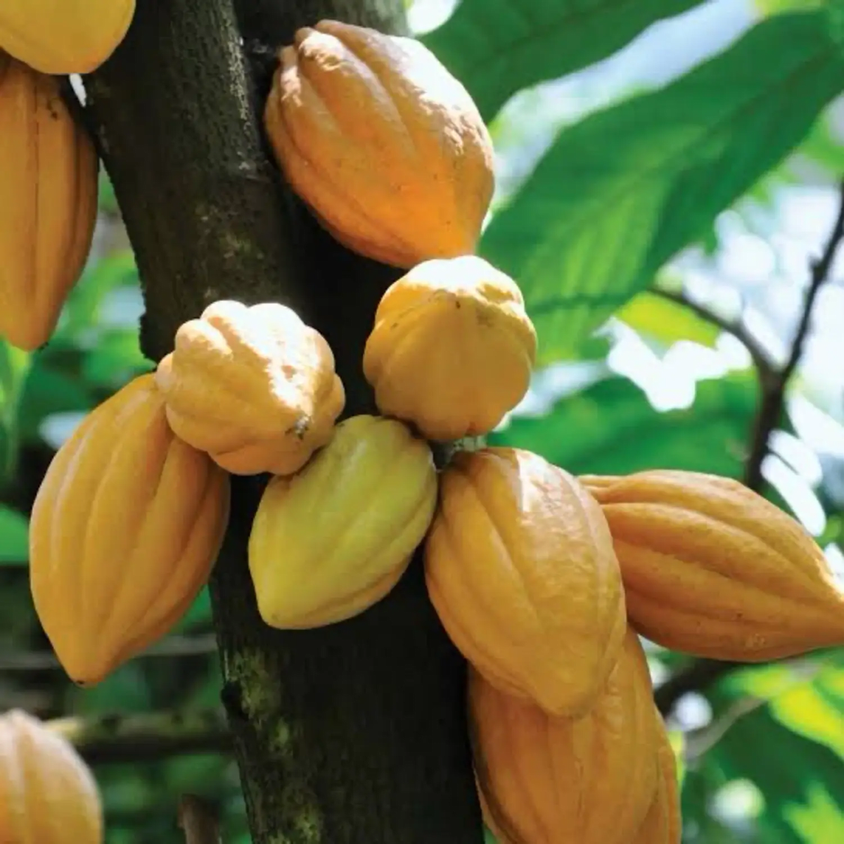
a. Which crop is shown growing in the picture?
b. Which country in Africa produces the most of this crop?
c. This crop was considered as 'Foods of Gods'. Give the reason for it being called so.
d. Mention a favourite drink you can make from this crop.
Answer
a. The crop shown growing in the picture is cocoa (the cocoa pods on a cocoa tree).
b. Ghana is the country in Africa that produces the most of this crop, being one of the largest producers and exporters of cocoa in the world.
c. The Aztecs regarded cocoa as the 'food of the Gods' because of its nutritional value. It contains about 20 per cent protein, 40 per cent carbohydrates and 40 per cent fat.
d. A favourite drink made from cocoa is hot chocolate.
Look at the given picture and answer the following questions.
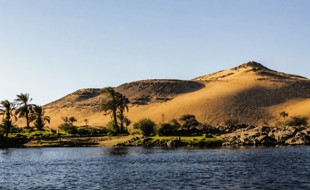
a. Name the river shown in the picture.
b. What is the source of this river?
c. What body of water does the river drain into?
Answer
a. The river shown in the picture is the Nile (the River Nile in Egypt).
b. The source of this river is near Lake Victoria, as it originates from the rainy equatorial region.
c. The river flows northwards and drains into the Mediterranean Sea.
Read the passage given below and answer the questions that follow:
The plateau region extends from the Guinea Coast in the west to Somalia in the east and from Sahara in the north to the Cape Province in the south. The height of the plateau ranges from 2,000 to 4,000 feet in different parts of the continent.
The Drakensberg Mountains of South Africa represent the steep edge of the plateau in the south. The East African Plateau in Kenya, Tanzania, and Uganda also rises steeply from the east coast. The Ethiopian Plateau in the northeast is composed of highlands of volcanic origin that are agriculturally productive. The relatively depressed regions are called basins, e.g., the Chad and Congo Basins. The Chad Basin forms the largest area of inland drainage in Africa. Several small rivers drain into Lake Chad instead of flowing into oceans and seas.
a. Which mountains form the steep edge of the plateau in the south?
b. Name the plateau which is of volcanic origin.
c. Name the depressed landforms lying in between the plateaus. Give two examples.
Answer
a. The Drakensberg Mountains of South Africa form the steep edge of the plateau in the south.
b. The Ethiopian Plateau is of volcanic origin, being composed of highlands of volcanic origin that are agriculturally productive.
c. The depressed landforms lying in between the plateaus are called basins. Two examples are the Chad Basin and the Congo Basin.