
The process of breaking and removing the rocks from the surface of the earth:
- Erosion
- Mass movement
- Denudation
- Weathering
Answer
Denudation
Reason — Denudation is the overall process of breaking down and removing rocks from the Earth's surface through weathering, erosion, and mass movement. Weathering only breaks down rocks, while erosion removes them.
Denudation is the process that wears away landmass and reshapes the surface of the earth. Which of the following process is NOT involved in it?
- Weathering
- Erosion
- Deposition
- Mass wasting
Answer
Deposition
Reason — Denudation includes weathering, erosion, mass movement, and transportation. Deposition is not involved because it builds up landforms by laying down transported materials.
The disintegration of rocks by atmospheric agents at or near the surface of the earth:
- Erosion
- Weathering
- Mass movement
- Denudation
Answer
Weathering
Reason — Weathering is the breakdown of rocks at or near the Earth's surface by weathering agents, without the removal of the broken material.
The displacement of rocks by agents like wind, water or ice:
- Deposition
- Transportation
- Erosion
- Mass wasting
Answer
Erosion
Reason — Erosion is the removal and displacement of weathered rock material by agents such as wind, water, ice, or waves. Unlike weathering, it involves the movement of rock particles.
The large-scale movement of loose materials (rock-waste) down the slope on account of gravity:
- Mass movement
- Deposition
- Denudation
- Weathering
Answer
Mass movement
Reason — Mass movement (mass wasting) is the downward movement of loose rock and soil under the force of gravity. Steeper slopes increase the speed of movement.
Assertion (A): In the upper course the dominant activity of a river is erosion.
Reason (R): The river flows swiftly as the gradient is steep.
- Both A and R are true and R is the correct explanation of A.
- Both A and R are true but R does not explain A.
- A is true but R is false.
- A is false but R is true.
Answer
Both A and R are true and R is the correct explanation of A.
Explanation — In the upper course, the river flows over a steep gradient, giving it high velocity. This increases its erosive power, making erosion the dominant activity.
The laying down of material that has been weathered, eroded and transported by natural processes such as water, wind and ice.
- Physical Weathering
- Deposition
- Denudation
- Tributary
Answer
Deposition
Reason — Deposition is the laying down of weathered, eroded, and transported materials by agents such as water, wind, and ice. Weathering breaks down rocks, while denudation wears away the land surface.
The streams or small rivers which join the main river are called:
- Transporteries
- Tributaries
- Distributaries
- Meanders
Answer
Tributaries
Reason — Tributaries are streams or smaller rivers that join a main river. Distributaries are channels that branch off from the main river, usually in the delta region.
When a river divides into channels or smaller rivers they are called its:
- Tributaries
- Distributaries
- Meanders
- Transporteries
Answer
Distributaries
Reason — Distributaries are channels that branch off from the main river, usually in its lower course, and contribute to the formation of a delta.
Assertion (A): River meanders are bends of longitudinal courses.
Reason (R): Meanders are the result of both erosion and deposition under conditions of a gentle slope and sufficient water in rivers.
- Both A and R are true and R is the correct explanation of A.
- Both A and R are true but R does not explain A.
- A is true but R is false.
- A is false but R is true.
Answer
Both A and R are true and R is the correct explanation of A.
Explanation — Meanders are the result of both erosion and deposition work of rivers. Meanders generally form under conditions of a gentle slope and sufficient water in rivers. The river flow is diverted by an obstruction allowing the river to do lateral erosion work.
In the upper course the dominant activity of a river is:
- Valley
- Meander
- Erosion
- Mass wasting
Answer
Erosion
Reason — In its upper course, a river flows over a steep gradient with high velocity, giving it great erosive power. Therefore, erosion is the dominant activity.
In the middle course of a river the gradient is gentle so the flow of the river slows down such that it appears like a snake over its floodplains forming which of the following?
- Deltas
- Gorges
- Meanders
- Rapids
Answer
Meanders
Reason — In the middle course, the river flows more slowly due to a gentle gradient. The combined action of lateral erosion and deposition causes the river channel to develop curved, snake-like bends called meanders.
............... are moon-shaped dunes.
- Dunes
- Sand Dunes
- Barchans
- Seifs
Answer
Barchans
Reason — Barchans are moon-shaped dunes. They are live dunes which advance steadily before winds that blow from a particular direction and are found in the deserts of the Sahara.
Stationary, long and narrow sand-ridges which grow parallel to the direction of the prevailing wind and remain in a fixed position.
- Dunes
- Sand Dunes
- Barchan
- Seifs
Answer
Seifs
Reason — Seifs (longitudinal dunes) are long, narrow sand ridges that form parallel to the prevailing wind. They remain stationary, unlike barchans, which migrate with the wind.
The lowering of land, rounding of exposed rock surfaces and levelling of the peaks:
- Denudation
- Erosion
- Mass wasting
- Deposition
Answer
Denudation
Reason — Denudation is the wearing away of the land by weathering, erosion, mass movement, and transportation. It lowers land surfaces, rounds exposed rocks, and levels mountain peaks.
Assertion (A): In the lower course of the river all the ideal conditions for depositional landforms exist.
Reason (R): The load-transporting capacity is drastically reduced due to sluggish flow as well as division of a river into many distributaries.
- Both A and R are true and R is the correct explanation of A.
- Both A and R are true but R does not explain A.
- A is true but R is false.
- A is false but R is true.
Answer
Both A and R are true and R is the correct explanation of A.
Explanation — In the lower course, the river flows slowly and often divides into distributaries, reducing its load-carrying capacity. As a result, deposition becomes dominant, leading to the formation of depositional landforms such as floodplains, levees, and deltas.
Which amongst the following is not a factor affecting work of a river?
- Velocity of water
- Quality of water
- Volume of water
- Load of water
Answer
Quality of water
Reason — The work of a river depends on its velocity, volume, and the load it carries. Quality of water does not significantly affect its processes of erosion, transportation, and deposition.
How do migratory dunes damage towns and villages?
- They cover all surfaces with thick layers of sand.
- The large mass of sand shifts further.
- They can be checked by building walls.
- All of the above.
Answer
They cover all surfaces with thick layers of sand.
Reason — Migratory sand dunes move with the wind and can bury towns, villages, roads, and farmland under thick layers of sand, causing extensive damage.
Assertion (A): Barchan are moon-shaped live dunes.
Reason (R): The migration of the barchans is a threat to desert life.
- Both A and R are true and R is the correct explanation of A.
- Both A and R are true but R does not explain A.
- A is true but R is false.
- A is false but R is true.
Answer
Both A and R are true but R does not explain A.
Explanation — Barchans are crescent (moon)-shaped, migratory sand dunes formed by winds blowing predominantly from one direction. Their migration can bury oases, vegetation, and settlements, posing a threat to desert life. However, this consequence does not explain why barchans are moon-shaped live dunes.
Name the landform that is formed as a result of the action of wind wherein loose materials are lifted and blown off to be deposited outside the desert margins.
- Sand Dunes
- Barchans
- Deflation Hollows
- Seifs
Answer
Deflation Hollows
Reason — Deflation removes loose sand and dust by wind, lowering the land surface and forming deflation hollows. The finer particles may be carried and deposited beyond the desert margins.
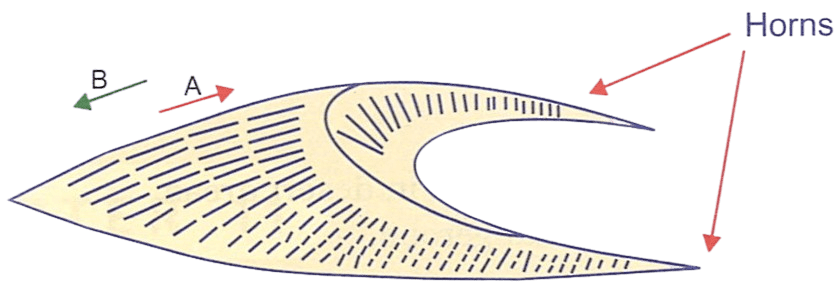
See the below figure of a barchan and identify the direction of the wind.
- A
- B
- Both A and B
- Neither A nor B.
Answer
A
Reason — Barchans form across the wind, with their horns pointing in the direction of the wind. Since the horns point towards A, the wind is blowing towards A.
Complete the following table:
| Stages | Effect on the river | Work of the river | Effect on land |
|---|---|---|---|
| Young Stage (Upper Course) | Formation of gorge, rapids and waterfalls. | Mainly erosion. | Formation of V-shaped valleys. |
| Maturity Stage (Middle Course) | ............... | ............... | ............... |
| Old Stage (Lower Course) | ............... | ............... | ............... |
Answer
| Stages | Effect on the river | Work of the river | Effect on land |
|---|---|---|---|
| Young Stage (Upper Course) | Formation of gorge, rapids and waterfalls. | Mainly erosion. | Formation of V-shaped valleys and I-shaped valleys. |
| Maturity Stage (Middle Course) | River gets widened due to volume of water and load | Erosion and transportation | Formation of meanders, oxbow lakes and floodplains. |
| Old Stage (Lower Course) | River flow is sluggish and load-transporting capacity is drastically reduced | Mainly deposition | Formation of deltas. |
What do you mean by denudation?
Answer
Denudation is the process of breaking and removing the rocks from the surface of the earth. It includes weathering, erosion, mass movement and transportation.
Name the factors which affect work of a river.
Answer
The factors which affect work of a river are-
- Velocity of water
- Volume of water
- Load
What is the main function of a river in its upper course? Name the landforms formed in the upper course of a river.
Answer
The main function of a river in its upper course is erosion. The river flows swiftly over a steep gradient, eroding its bed and banks and carrying large rock fragments.
The main landforms formed in the upper course are V-shaped valleys, gorges, and waterfalls.
How is a waterfall formed?
Answer
A waterfall is formed due to differential erosion. A layer of hard, resistant rock overlies soft rock. The soft rock is eroded more rapidly, forming a plunge pool at the base. As erosion continues, the hard rock is left as an overhang, which eventually collapses, and the waterfall gradually retreats upstream.
State the two characteristics of a river in its middle course.
Answer
The two characteristics of a river in its middle course are-
- Lateral erosion is more active than vertical (downward) erosion.
- The volume of water increases as many tributaries join the main river.
How are meanders formed? Give one example of a meander.
Answer
Meanders generally form under conditions of a gentle slope and sufficient water in rivers. The river flow is diverted by an obstruction allowing the river to do lateral erosion work.
The Ganga in India is famous for its meanders.
Name one landform in the lower course of a river. How is it formed?
Answer
One landform formed in the lower course of a river is a delta.
A delta is formed when the river slows down near its mouth, reducing its load-carrying capacity. The river deposits sediments and divides into distributaries. Over time, these deposits accumulate to form a triangular-shaped landform called a delta, resembling the Greek letter Δ (delta).
Where is wind erosion most predominant?
Answer
Wind erosion is most predominant in arid regions such as deserts.
What are known as Deflation Hollows?
Answer
Deflation results in the lowering of the land surface to create depressions called deflation hollows.
Name two chief landforms formed by wind erosion.
Answer
Two chief landforms formed by wind erosion are deflation hollows and sand dunes.
Name two chief types of sand dunes.
Answer
Two chief types of sand dunes are-
- Barchan
- Longitudinal dunes or Seifs
State any two characteristics of barchans.
Answer
Two characteristics of barchans are-
- They occur transversely to the wind, so that their horns thin out and become lower in the direction of the wind.
- The windward side is convex and gentle-sloping while the leeward side is concave and steep.
State the difference between weathering and denudation.
Answer
| Weathering | Denudation |
|---|---|
| Weathering is the process of breaking down of rocks but not its removal. | Denudation is the process of breaking and removing the rocks from the surface of the earth. |
| It is only a part of denudation cycle. | It includes weathering, erosion, mass movement and transportation. |
| Weathering is a short-term process. | Denudation is a long-term process. |
| The main agents of weathering are temperature, moisture, frost action, wind, oxygen, organic acids etc. | The four active agents of denudation are water, wind, waves and glacial ice. |
Name the various processes involved in denudation. What are the results of denudation?
Answer
The various processes involved in denudation are-
- Weathering
- Erosion
- Mass movement or mass wasting
- Transportation
- Deposition
The results of denudation are the formation of erosional or depositional landforms on the surface of the earth.
Give a geographical reason for each of the following:
(i) Erosion is the dominant activity of a river in its upper course.
(ii) Landforms of deposition are more prominent in the middle course of a river.
(iii) All the rivers do not form deltas.
Answer
(i) Erosion is the dominant activity of a river in its upper course because the river flows swiftly over a steep gradient, giving it great erosive power.
(ii) Landforms of deposition are more prominent in the middle course because the gradient becomes gentler, reducing the river's velocity. As a result, it begins to deposit part of its load, while lateral erosion becomes more active than vertical erosion.
(iii) All rivers do not form deltas because delta formation requires a large sediment supply, a gentle coast with calm water, and a river with sufficient discharge. Where these conditions are absent, rivers may form estuaries instead.
Describe the work of wind erosion and state two important landforms of wind erosion.
Answer
Wind erosion is the process by which wind picks up, wears away, and transports loose rock particles such as sand and dust from one place to another. It shapes the land by removing and abrading surface materials.
Two important landforms of wind erosion are:
- Deflation hollows
- Mushroom rocks (rock pedestals)
Briefly describe the factors which affect the work of a river.
Answer
The factors which affect the work of a river are-
1. Velocity of water — Erosion and transportation are greatest when the velocity is high. Deposition occurs when the velocity decreases.
2. Volume of water — A larger volume of water increases the river's capacity for erosion and transportation. Deposition is more likely when the volume and velocity decrease.
3. Load — The amount and size of the load carried by a river influence its erosional and depositional work. The load helps deepen river valleys and contributes to the formation of various landforms.
Describe the three stages of a river.
Answer
The three stages of a river are-
- Upper course — In the upper course, the river flows rapidly because of the steep gradient, usually through mountainous or hilly regions. The river mainly performs vertical erosion and deepens its valley. It carries coarse materials such as boulders and pebbles through erosion and transportation. Features such as V-shaped valleys, waterfalls, rapids, and gorges are formed in this stage.
- Middle course — In the middle course, the gradient becomes gentler and the river flows more slowly. The volume of water increases as tributaries join the main river. Lateral erosion becomes more prominent, causing the widening of the river valley. Meanders and wider valleys are common features of this stage.
- Lower course — In the lower course, the river flows slowly over a gentle gradient and mainly deposits the sediments it carries. The river forms depositional features such as floodplains, levees, and deltas. Near its mouth, the river may divide into distributaries before entering a sea or lake.
Give a geographical reason for each of the following:
(i) The effects of wind erosion are more pronounced in desert areas.
(ii) Migratory sand dunes are uncertain and dangerous.
(iii) Long rooted trees and sand holding grasses are grown bordering fields near deserts.
Answer
(i) The effects of wind erosion are more pronounced in desert areas since there is little vegetation or moisture to bind the loose surface materials.
(ii) Migratory sand dunes are uncertain and dangerous because when they migrate with the wind, they damage towns and villages.
(iii) Long rooted trees and sand holding grasses are grown bordering fields near deserts to halt the advance of the dunes in order to prevent the fertile land from being devastated.
State the factors on which the shape and size of dunes depend?
Answer
The factors on which the shape and size of dunes depend are:
- The direction and force of wind.
- The speed of wind, carrying the dust and sand particles.
- The nature and amount of sand brought by the wind.
- Water features like lakes, streams etc., in the close-by area.
- The nature of vegetation on the land.
- The nature of the surface, where the formation of a sand dune takes place.
Given below is a photograph of Purwa Waterfall on the River Tamsa in Madhya Pradesh. Answer the following questions:
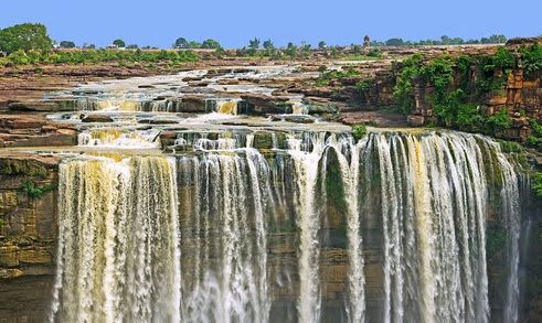
(a) What stage is the River Tamsa to cause formation of this waterfall? Give reasons to support your answer.
(b) What other landforms would a river make in this stage?
(c) What landforms would the River Tamsa make in the next stage of its flow?
(d) Besides being a tourist attraction waterfalls are important sources of energy. Elucidate.
Answer
(a) The River Tamsa is in its youthful stage (upper course). This can be understood from the presence of Purwa Waterfall.
The river flows through a steep gradient in its upper course, where vertical erosion is dominant. The rapid downward cutting of the river over an escarpment or uneven rock surface leads to the formation of waterfalls. The presence of waterfalls, steep slopes, and deep valleys are characteristic features of the youthful stage of a river
(b) Other landforms (apart from Waterfalls) formed during the youthful stage are —
- Rapids
- V-shaped valleys and I-shaped valleys
- Gorges
- Canyons
(c) River Tamsa would form the following landforms in the next stage, i.e., mature stage (or middle course) —
- Meanders
- Oxbow lakes
- Floodplains
- Wider V-shaped valleys
(d) Importance of waterfalls as energy sources:
- Waterfalls provide a high potential energy source due to falling water.
- They are used for generating hydroelectric power (HEP).
- Hydroelectric power is renewable and reduces dependence on fossil fuels.
What is the relationship between denudation, weathering and erosion? Give examples to support your answer.
Answer
Denudation, weathering, and erosion are interconnected processes that modify the Earth's surface. Denudation is the overall process of wearing away and lowering of the Earth's surface. It includes weathering, erosion, and transportation of materials.
Weathering is the breakdown or disintegration of rocks at their original place due to physical, chemical, or biological processes. It prepares rocks for erosion. For example, repeated heating and cooling can cause rocks to crack and break into smaller pieces.
Erosion is the removal and transportation of weathered rock materials from one place to another by natural agents such as rivers, wind, glaciers, and waves. For example, river erosion can carve valleys and gorges by carrying away sediments.
Thus, weathering breaks rocks into smaller particles, erosion removes and transports these materials, and together they contribute to denudation, which gradually changes the Earth's surface.
While travelling from Haridwar to Prayagraj, the course of which river did you follow? List the landforms associated with it along the course you followed.
Answer
While travelling from Haridwar to Prayagraj, I followed the course of the River Ganga.
Along this stretch, the Ganga flows through its middle and lower course, forming several fluvial landforms such as:
- Meanders
- Floodplains
- Natural levees
- Point bars (slip-off slopes)
- Oxbow lakes (in some places)
At Prayagraj, the Ganga also forms a confluence (Sangam) with the Yamuna and the mythical Saraswati.
In this chapter you have studied the action of winds that results in desertification in arid areas. Make a list of activities that could prevent and reverse desertification.
Answer
Some activities that could prevent and reverse desertification are:
- Afforestation and planting shelter belts (windbreaks): Trees reduce wind speed, bind the soil with their roots, and prevent wind erosion.
- Planting long-rooted trees and sand-binding grasses: These help stabilize sand dunes and prevent them from spreading over fertile land.
- Rainwater harvesting and proper irrigation: These improve soil moisture and support vegetation growth in dry regions.
- Controlled grazing: Preventing overgrazing allows vegetation to regenerate and protects the soil from erosion.
- Sustainable farming practices: Crop rotation, mulching, and maintaining vegetation cover help conserve soil and reduce degradation.
- Public awareness and proper land-use planning: Encouraging sustainable use of natural resources and preventing deforestation help combat desertification.