
Hydrosphere refers to the combined mass of water :
- in the oceans
- rivers, streams and lakes
- in the atmosphere
- All of the above.
Answer
All of the above
Reason — The hydrosphere includes all the water present on Earth.
Water is not usually thought of as a solid, and only a small fraction of the Earth's water is in a solid state, in the form of ice. This ice includes all forms of frozen water, from the ice sheets at the North and South poles to icebergs, ice on the top of mountains, frozen lakes in the winter, or even the ice in a freezer. Though all the ice on earth is part of the hydrosphere, the frozen aspect is known as the cryosphere. This frozen water is three-fourths of the earth's freshwater, which makes it quite important. Identify other sources of fresh water.
- rivers, lakes and streams
- underground water
- reservoirs and dams
- All of the above.
Answer
All of the above.
Reason — Apart from the ice stored in the cryosphere, freshwater is available as surface water in rivers, lakes, and streams; as groundwater stored beneath the Earth's surface; and as water stored in man-made reservoirs and dams. Therefore, all the options listed are sources of freshwater.
Underground water is found in:
- soil
- subsoil
- underground streams
- All of the above.
Answer
All of the above
Reason — Rainwater that seeps into the ground is stored as groundwater in the soil, subsoil, and underground water-bearing layers (aquifers). Hence, the correct answer is All of the above.
Assertion (A): Waves are oscillatory movements on the surface of the sea.
Reason (R): Waves result from the action of wind on the surface of the sea.
- Both A and R are true and R is the correct explanation of A.
- Both A and R are true but R does not explain A.
- A is true but R is false.
- A is false but R is true.
Answer
Both A and R are true and R is the correct explanation of A.
Explanation — Waves are oscillatory movements characterized by the alternate rise and fall of the sea surface. They are mainly generated by the action of wind blowing over the surface of the sea. Therefore, the reason correctly explains why waves are formed.
Name the rise and fall of sea water due to the gravitational forces of the sun and the moon:
- Tides
- Waves
- Spheres
- Oscillations
Answer
Tides
Reason — Tides are the periodic rise and fall of sea water caused by the gravitational pull of the Moon and the Sun. In contrast, waves are oscillatory movements of sea water mainly caused by winds blowing over the ocean surface.
The difference in height between high tide and low tide is called ................
- Ebb
- Tidal wave
- Tidal range
- Tidal crest
Answer
Tidal range
Reason — The tidal range is the difference in the height of sea level between high tide and low tide.
Apogee : Earth-moon distance ............... :: Perigee : Earth-moon distance ...............
- maximum, minimum
- minimum, maximum
- equal, equal
- All of the above.
Answer
maximum, minimum
Reason — The Moon revolves around the Earth in an elliptical orbit, so its distance from the Earth varies. The apogee is the point where the Moon is farthest from the Earth (maximum distance), while the perigee is the point where it is closest to the Earth (minimum distance).
Study the diagram and identify A and B.
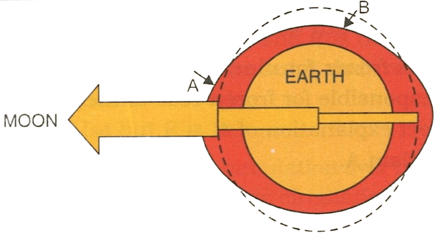
- A: High tide B: Low tide
- A: Low tide B: Low tide
- A: Low tide B: High tide
- A: High tide B: High tide
Answer
A: High tide B: Low tide
Reason — The side of the Earth facing the Moon (A) experiences the greatest gravitational pull, causing a high tide. At right angles to it (B), the water level falls, resulting in a low tide.
Assertion (A): Tidal range is not constant.
Reason (R): Tidal range varies due to the earth's rotation on its axis.
- Both A and R are true and R is the correct explanation of A.
- Both A and R are true but R does not explain A.
- A is true but R is false.
- A is false but R is true.
Answer
A is true but R is false.
Explanation — The tidal range (the difference between high tide and low tide) is not constant. It mainly varies due to the changing positions of the Moon and the Sun and the Moon's varying distance from the Earth (perigee and apogee). The Earth's rotation causes the regular occurrence of tides but does not cause variations in the tidal range.
Which of the following statements are true?
(A) The alternate advance and retreat of seawater along a coast is called tide.
(B) When water advances to its fullest extent on to the shore it is called high tide.
(C) When water recedes to its fullest extent from the shore it is called low tide.
(D) Some freshwater rivers and lakes can have tides too.
- (A) (B) (C) (D)
- Only (A)
- Only (B) and (C)
- (A) (B) and (C)
Answer
(A) (B) (C)
Reason — A tide is the alternate advance and retreat of sea water along a coast. When the sea water advances to its greatest extent onto the shore, it is called high tide; when it recedes to its greatest extent, it is called low tide. Statement (D) is incorrect because tides are a characteristic feature of oceans and seas.
............... flow from the lower latitudes towards the higher latitudes.
- Warm currents
- Cold currents
- Surface currents
- Deep water currents
Answer
Warm currents
Reason — Warm currents flow from the low latitudes (tropical regions) towards the high latitudes (temperate and polar regions), carrying warm water into colder areas. In contrast, cold currents flow from the high latitudes towards the low latitudes, carrying cold water into warmer regions.
Which amongst the following is NOT one of the causes of Ocean Currents?
- Level of Salinity
- Temperature
- The Earth's Revolution
- Planetary Winds
Answer
The Earth's Revolution
Reason — Ocean currents are influenced by factors such as temperature, salinity, planetary winds, the Earth's rotation, and the shape of continents (landmasses). The Earth's rotation causes the Coriolis effect, which deflects ocean currents. However, the Earth's revolution around the Sun is not a direct cause of ocean currents.
The water from the Atlantic ocean flows over the Mediterranean sea because
- The latter is more saline.
- The latter is warmer.
- of the direction of westerlies.
- of the earth's rotation.
Answer
The latter is more saline.
Reason — The Mediterranean Sea has higher salinity than the Atlantic Ocean. As a result, its water is denser, while the less saline and lighter Atlantic water flows over the surface into the Mediterranean Sea through the Strait of Gibraltar. The denser Mediterranean water flows out beneath the Atlantic water.
Name the winds that blow between the Equator and the Tropics.
- Westerlies
- Trade Winds
- Monsoon Winds
- Summer Winds
Answer
Trade Winds
Reason — Trade Winds are permanent planetary winds that blow from the subtropical high-pressure belts (around 30° N and 30° S) towards the Equatorial low-pressure belt. They prevail between the Equator and the Tropics. These winds also help drive warm ocean currents westward in the tropical regions.
What is the direction of air circulation over the oceans in the middle latitudes?
- Cyclonic
- Hemispherical
- Spherical
- Anticyclonic
Answer
Anticyclonic
Reason — The pattern of ocean circulation broadly corresponds to the Earth's atmospheric circulation. In the middle latitudes, air circulation over the oceans is predominantly anticyclonic, especially in the Southern Hemisphere, while cyclonic circulation is more common at higher latitudes.
Assertion (A): Gulf stream flows in a clockwise direction.
Reason (R): In the Northern Hemisphere currents flow in a clockwise direction.
- Both A and R are true and R is the correct explanation of A.
- Both A and R are true but R does not explain A.
- A is true but R is false.
- A is false but R is true.
Answer
Both A and R are true and R is the correct explanation of A.
Explanation — The Gulf Stream is part of the North Atlantic Ocean gyre, which circulates in a clockwise direction in the Northern Hemisphere. This is mainly due to the Coriolis effect caused by the Earth's rotation, together with the influence of planetary winds and the shape of the continents. Therefore, the reason correctly explains the assertion.
Name the warm Atlantic Ocean Current which keeps the ports of Great Britain ice free even in winters.
- The West Atlantic Drift
- The East Atlantic Drift
- The North Atlantic Drift
- The South Atlantic Drift
Answer
The North Atlantic Drift
Reason — The warm Gulf Stream is deflected eastwards by the Westerlies and the rotation of the earth and reaches Europe as the North Atlantic Drift. It is a warm current which keeps the ports of Great Britain and the rest of western Europe free from ice even in winter, and the British Isles enjoy a mild climate on account of its influence.
Assertion (A): The Labrador Current remains frozen for nine months.
Reason (R): The cold Arctic Current is responsible for frozen seas of the Labrador Current.
- Both A and R are true and R is the correct explanation of A.
- Both A and R are true but R does not explain A.
- A is true but R is false.
- A is false but R is true.
Answer
Both A and R are true and R is the correct explanation of A.
Explanation — The Labrador Current remains frozen for nine months on account of the influence of the cold Arctic Current.
Identify the Warm Currents flowing in the Atlantic ocean.
- Gulf Stream — North Atlantic Drift
- Labrador Current — Irminger Current
- Canaries Current — Cayenne Current
- Alaska Current — California Current
Answer
Gulf Stream — North Atlantic Drift
Reason — The Gulf Stream and its extension, the North Atlantic Drift, are warm currents of the Atlantic Ocean. The Labrador, Irminger, and Canary Currents are cold currents. The Alaska and California Currents are found in the Pacific Ocean, not the Atlantic.
The Gulf Stream Current is deflected towards the east as a result of the earth's rotation and the westerlies to become the
- Labrador Current
- North Atlantic Drift
- Sargasso Sea
- Arctic Current
Answer
North Atlantic Drift
Reason — The Gulf Stream, a warm ocean current, is deflected eastward by the Westerlies and the Coriolis effect (caused by the Earth's rotation). It then continues across the North Atlantic as the North Atlantic Drift, warming the coasts of Western Europe.
Assertion (A): The water which gets collected under the surface of the land, known as underground water, remains in soil, sub-soil or bedrock.
Reason (R): The water from precipitation, that is from rain or snow flows on the surface.
- Both A and R are true and R is the correct explanation of A.
- Both A and R are true but R does not explain A.
- A is true but R is false.
- A is false but R is true.
Answer
Both A and R are true but R does not explain A.
Explanation — While both statements are scientifically accurate, the Reason describes surface runoff, which is the opposite of how underground water is formed. For R to be the correct explanation of A, it would need to explain infiltration that is, how water seeps down into the ground rather than how it flows on top of it.
Assertion (A): On the seventh or eighth day of every fortnight a neap tide, which is lower in height than a low tide, occurs.
Reason (R): The tide producing forces of the sun and the moon work in opposite direction causing a low tide.
- Both A and R are true and R is the correct explanation of A.
- Both A and R are true but R does not explain A.
- A is true but R is false.
- A is false but R is true.
Answer
A is false but R is true.
Explanation — On the seventh or eighth day of every fortnight a neap tide, which is lower in height than a normal tide, occurs. The height of neap tides is generally 20 per cent lower than that of the normal tides.
Which current is also known as the 'Black Stream'?
- Atlantic current
- Kuroshio current
- Oyashio current
- Newfoundland current
Answer
Kuroshio current
Reason — The Kuroshio Current is a warm ocean current in the western North Pacific Ocean. It is also known as the Black Stream, as Kuroshio is the Japanese term meaning "Black Current" or "Black Stream", referring to the deep blue-black appearance of its waters. It is also called the Japan Current.
Name the current that keeps the hub of world trade, the Port of Montreal, open all year round.
- Gulf Stream
- Labrador current
- Canaries current
- Florida current
Answer
Gulf Stream
Reason — The Gulf Stream is a warm ocean current that raises the temperature of nearby coastal regions and helps keep many ports ice-free during winter. Owing to its influence, the Port of Montreal on the St. Lawrence River remains open for navigation for most of the year, unlike ports affected by cold currents, such as Vladivostok, which remain ice-bound in winter.
Which currents have created one of the world's richest fishing grounds?
- Labrador current and Gulf stream
- Labrador current and Irminger current
- Oyashio current and Kuroshio current
- Both (1) and (3).
Answer
Both (1) and (3)
Reason — The Labrador Current meets the warm Gulf Stream near the Grand Banks of Newfoundland, creating one of the world's richest fishing grounds. Similarly, the cold Oyashio Current meets the warm Kuroshio Current off the coast of Japan, forming another rich fishing ground. Therefore, both (1) and (3) are correct.
Assertion (A): Warm currents flow from the low latitudes in Tropical Zones towards the high latitudes.
Reason (R): They bring warm water into cold water areas.
- Both A and R are true and R is the correct explanation of A.
- Both A and R are true but R does not explain A.
- A is true but R is false.
- A is false but R is true.
Answer
Both A and R are true and R is the correct explanation of A.
Explanation — Warm currents are those currents which flow from the low latitudes in Tropical Zones towards the high latitudes in the Temperate and Sub-polar Zones. They bring warm water into cold water areas, influencing climate and marine life.
Assertion (A): The air circulation over the oceans in the middle latitudes is mainly anticyclonic.
Reason (R): The oceanic circulation pattern corresponds with the circulation of air.
- Both A and R are true and R is the correct explanation of A.
- Both A and R are true but R does not explain A.
- A is true but R is false.
- A is false but R is true.
Answer
Both A and R are true and R is the correct explanation of A.
Explanation — The pattern of ocean circulation broadly corresponds to the Earth's atmospheric circulation because ocean currents are largely driven by the prevailing winds and influenced by the Coriolis effect. Since air circulation over the oceans in the middle latitudes is mainly anticyclonic, the ocean circulation in these latitudes also follows an anticyclonic pattern.
Currents influence which of the following?
- temperature
- rainfall
- fish population
- all of the above.
Answer
all of the above
Reason — Ocean currents influence the temperature of coastal regions, making them warmer or cooler. Warm currents generally increase rainfall, while cold currents reduce it. Ocean currents also bring nutrient-rich waters that promote the growth of plankton, supporting abundant fish populations. Hence, ocean currents influence all of the above.
Name any two ways in which movement of ocean water takes place.
Answer
Two ways in which movement of ocean water takes place are-
- Waves
- Currents
What are tides? Name one factor that causes tides.
Answer
The rise and fall of sea water due to gravitational forces of the sun and the moon are called tides.
Tides are caused by the gravitational forces of the sun and moon.
What is the time interval between tides? Name the factors responsible for this time interval.
Answer
The Earth takes 24 hours 52 minutes to complete one rotation relative to the Moon (a lunar day). Since there are two high tides in one lunar day, the interval between successive high tides is about 12 hours 26 minutes. This time interval is due to the Earth's rotation and the Moon's revolution around the Earth.
What are Spring and Neap tides?
Answer
Spring tides are very high tides that occur when the Sun, the Moon, and the Earth are almost in the same line. At this time, the gravitational pull of the Sun and the Moon combine to produce very high tides.
Neap tides occur on the seventh or eighth day of each fortnight, when the Sun, the Earth, and the Moon are in quadrature (at right angles). The tide-producing forces of the Sun and the Moon act at right angles to each other, resulting in tides that are lower than normal.
Mona had gone to visit her friend's boat on the Visakhapatnam jetty. She was surprised to see that the boats seemed to have sunk because the water level in the jetty was low and the gangways to the boats were almost vertical. As a student of geography name and explain the phenomena that caused this.
Answer
The phenomenon that Mona observed is called a Low Tide.
Tides are the periodic rise and fall of sea level caused by the gravitational pull of the Moon and the Sun. During low tide, the sea water recedes from the shore, lowering the water level. As a result, boats at the jetty appear to have sunk, and the gangways become steep or almost vertical.
Name two types of ocean currents based on their temperature. Give an example of each.
Answer
Two types of ocean currents based on their temperature are-
- The Warm Currents, e.g. Gulf Stream
- The Cold Currents, e.g. Labrador current
For what is the Gulf Stream famous?
Answer
The Gulf Stream is a powerful warm ocean current affecting the climate of east coast of North America and west coast of Europe. It is also a potential source of renewable power generation.
What happens when warm and cold currents meet?
Answer
The combination of warm and cold currents produces heavy fogs and creates rich fishing grounds.
Tara had gone to Canada to visit her cousins staying in Newfoundland. Her cousins took her to the seaside where they encountered heavy fog. As a student of geography Tara explained the cause of the fog. What did Tara say? What is the main occupation of the people in that place?
Answer
Tara explained that the heavy fog along the coast of Newfoundland is caused by the meeting of the warm Gulf Stream and the cold Labrador Current. The warm, moisture-laden air over the Gulf Stream cools rapidly on coming into contact with the cold Labrador Current, causing the water vapour to condense into thick fog.
The meeting of these two currents also creates one of the world's richest fishing grounds. Therefore, the main occupation of the people of Newfoundland is fishing.
How are tides formed?
Answer
Tides are formed due to the gravitational pull of the Moon and the Sun on the Earth's oceans. The Moon's gravitational pull has the greater effect. As the Earth rotates, the sea water rises and falls, producing high tides and low tides.
When the Sun, the Earth, and the Moon are in a straight line, their gravitational forces combine to produce spring tides, which have the greatest tidal range. When the Sun and the Moon are at right angles with respect to the Earth, their gravitational forces partly oppose each other, producing neap tides, which have a smaller tidal range.
Differentiate between High Tides and Low Tides.
Answer
| High Tides | Low Tides |
|---|---|
| High water level during a tide is known as high tide. | Low water level during a tide is called low tide. |
| The sun, the earth and the moon are in the same line. | The sun and the moon are at the position of right angle with reference to the earth. |
| Gravitational forces of the sun and the moon work together. | Gravitational forces of the sun and the moon work against each other. |
Give a reason for each of the following:
(i) There are two high and two low tides in a day.
(ii) Each day a tide is delayed by 26 minutes.
(iii) The tidal range differs from one water body to the other.
Answer
(i) Because the Earth rotates through two tidal bulges every lunar day, coastal areas experience two high and two low tides every 24 hours and 52 minutes. This occurs because the moon is revolving around the Earth in the same direction as the Earth is rotating on its axis.
(ii) Each day a tide is delayed by 26 minutes because the moon also rotates on its axis while revolving around the earth. Since the earth rotates from west to east the tide centre shifts westwards. When the tide centre completes one round, the moon's position is ahead of the tide centre by that time. This delays the tide by 26 minutes each day.
(iii) The tidal range differs from one water body to the other as tidal range is not constant but changes depending on the locations of the moon and the sun.
Draw a well labelled diagram showing the formation of spring and neap tides.
Answer
Below diagram shows the formation of spring and neap tides:

Describe the two types of ocean currents based on their temperature.
Answer
The two types of ocean currents based on their temperature are-
1. The Warm Current — These are those currents which flow from the low latitudes in Tropical Zones towards the high latitudes in the Temperate and Sub-polar Zones. They bring warm water into cold water areas. For example, Gulf Stream.
2. The Cold Current — These currents have a lower surface temperature and bring cold water into warm water areas. These currents flow from the high latitudes in the Polar regions towards the low latitudes in the warm Equator region. For example, Labrador current.
State any two factors responsible for causing the currents.
Answer
Two factors responsible for causing the currents are-
- Level of Salinity
- Temperature
Give a reason for each of the following:
(i) Warm currents produce a milder climate.
(ii) The eastern coasts of USA are comparatively cold.
(iii) The coasts of Norway are not frozen in winter whereas its adjoining coasts are frozen for most parts of the year.
Answer
(i) Warm currents produce a milder climate because warm currents tend to raise the temperature of the places where they flow.
(ii) The eastern coast of USA is comparatively cold because of the cold Labrador Current.
(iii) The coasts of Norway are not frozen in winter whereas its adjoining coasts are frozen for most parts of the year on account of the influence of the warm North Atlantic Drift.
Describe one effect of each of the following three ocean currents.
(i) Labrador Current of the Atlantic Ocean.
(ii) The Kuroshio current
(iii) Oyashio Current of the Pacific Ocean.
Answer
(i) The waters of the Labrador current have a cooling effect on the Canadian Atlantic provinces and coastal New England.
(ii) The warm waters of the Kuroshio current sustain the coral reefs of Japan, which are the northernmost coral reefs in the world.
(iii) Oyashio current has an important impact on the climate of the Russian Far East, mainly in Kamchatka and Chukotka.
State the origin and flow of the Gulf Stream.
Answer
The Gulf Stream originates in the Gulf of Mexico, flows through the Strait of Florida along the eastern coast of North America, and then crosses the Atlantic Ocean. Near 30°W, 40°N, it divides, with one branch becoming the North Atlantic Drift towards Europe and the other turning south towards West Africa.
What is the effect of Gulf Stream on the coasts of North America and Western Europe?
Answer
The Gulf Stream influences the climate of the east coast of North America from Florida to Newfoundland, and the west coast of Europe. The current keeps these regions warm in winter.
Give a reason for each of the following:
(i) The waters of the Oyashio Current form the richest fishing grounds in the world.
(ii) There is heavy rainfall in Queensland but the Atacama desert is arid.
(iii) Rich fishing grounds are located on the Pacific coast of North America.
Answer
(i) The waters of the Oyashio Current form the richest fishing grounds in the world owing to the extremely high nutrient content of the cold water and the very high tides in some areas, which further enhances the availability of nutrients.
(ii) Warm currents flow towards Queensland which make the air warm and enable it to acquire greater moisture. Thus, the winds increase the amount of precipitation in Queensland while Atacama desert owe their existence to some extent to Benguela and Peru currents which are cold and keep the air dry and devoid of moisture.
(iii) Rich fishing grounds are located on the Pacific coast of North America due to the convergence of warm and cold currents.
Describe three major effects of currents.
Answer
Three major effects of currents are-
1. Effect on Climate — The climate of the coasts becomes warm or cool according to the current washing the coast which may be warm or cool.
2. Effect on Marine life — Ocean currents move organic material off the coast which is the food of planktons. The more the planktons, higher the concentration of fish.
3. Effect on commerce — On account of influence of warm currents, harbours are kept open in winter, facilitating trade throughout the year.
You are watching the sea waves from the balcony of a seaside resort in Mumbai on a New Moon Day. Suddenly you noticed rise of sea water and its movement towards the coast. What was this wave and after how much time will it be repeated?
Answer
The wave observed was a high tide (spring tide), as it was a New Moon Day. High tide occurs when sea water rises and moves towards the coast due to the gravitational pull of the Moon and the Sun. During the new moon, the Sun, the Moon, and the Earth are nearly in a straight line, producing spring tides, which have the greatest tidal range.
The next high tide will occur after approximately 12 hours and 26 minutes.
Imagine that the Ocean Currents stop flowing. What would be its consequences for the human beings?
Answer
The consequences of ocean currents ceasing would have significant effects on human beings:
- Extreme Climate Changes — Heat would not be distributed from the Equator to the poles, leading to extreme temperatures.
- Changes in Rainfall — Coastal regions would experience changes in rainfall, causing droughts in some areas and floods in others.
- Decline in Fisheries — The supply of nutrients to the oceans would decrease, reducing plankton growth and fish populations.
- Disruption of Navigation and Trade — Ocean routes used by ships would be affected, increasing travel time and costs.
- Adverse Effects on Coastal Economies — Fishing, tourism, and other coastal industries would suffer.
Thus, the absence of ocean currents would seriously affect climate, marine life, and human activities.