
How is direction shown on a map?
Answer
The direction is shown on the map with the help of North-South line . The arrow indicating up is considered as north and the arrow which indicates down, depicts south direction.
The line perpendicular to the North South line represent the east-west direction. The line on the right depicts east direction and the line towards the left depicts the west direction.
What do you understand by Representative Fraction?
Answer
It is a method of representing scale on the map. It is expressed as a fraction showing the ratio of a unit distance on the map and the distance measured in the same units on the ground.
What is the advantage of R.F.?
Answer
The main advantage of R.F. is that it is only a fraction and is independent of any particular unit of measurement. It can be converted into any particular unit of measurement and has universal application.
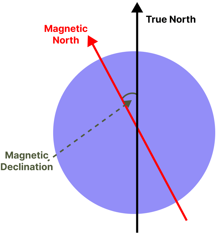
Explain Magnetic declination with the help of a diagram.
Answer
The angle between the true north-south line and the magnetic north-south line is known as magnetic declination. The diagram showing magnetic declination is shown below:
Why are 'True North' and 'Grid North' different?
Answer
'True North' and 'Grid North' are different because of the spherical shape of the earth.
What is a Scale? Name the main methods of representing the scale of a map.
Answer
The scale of a map denotes the proportion that the distance between any two points on the map bears to the distance between the same two points on the surface of the earth.
The main methods of representing the scale of a map are-
- A statement
- Graphic or Linear scale
- Representative Fraction
Convert the following statements into R.F.
(a) 25 cm on the map = 5 km on ground.
(b) 2½ inches on the map = 5 miles on ground.
(c) 7 cm on the map = 63000 metres on ground.
(d) 5 cm = 500 metres.
(e) 15 cm = 6 km.
Answer
(a) The scale is 25 cm to 5 km = 25 cm to 5,00,000 cm
(Since 1 km = 1,00,000 cm)
R.F. = Distance on the map / Distance on the ground
R.F. = 25 / 5,00,000
R.F. = 1:20,000
(b) The scale is 2½ inches to 5 miles = 2.5 inches to 3,16,800 inches
(Since 1 mile = 63,360 inches)
R.F. = Distance on the map / Distance on the ground
R.F. = 2.5 / 3,16,800
R.F. = 1:1,58,400
(c) The scale is 7 cm to 63000 m = 7 cm to 63,00,000 cm
(Since 1 m = 100 cm)
R.F. = Distance on the map / Distance on the ground
R.F. = 7 / 63,00,000
R.F. = 1:9,00,000
(d) The scale is 5 cm to 500 m = 5 cm to 50,000 cm
(Since 1 m = 100 cm)
R.F. = Distance on the map / Distance on the ground
R.F. = 5 / 50,000
R.F. = 1:10,000
(e) The scale is 15 cm to 6 km = 15 cm to 6,00,000 cm
(Since 1 km = 1,00,000 cm)
R.F. = Distance on the map / Distance on the ground
R.F. = 15 / 6,00,000
R.F. = 1:40,000
Convert the following representative fractions into statements:
(i) 1: 63360 (to show miles).
(ii) 1: 1000000 (to show kilometres).
(iii) 1: 100 (to show metres).
(iv) 1: 10 (to show metres).
(v) 1: 200,000 (to show kilometres).
Answer
(i) R.F. = 1:63360
That means 1 inch on the map = 63360 inches on the ground
The scale is 1 inch to 1 mile
(Since 1 mile = 63,360 inches)
(ii) R.F. = 1:10,00,000
That means 1 cm on the map = 10,00,000 cm on the ground
The scale is 1 cm to 10 km
(Since 1 km = 1,00,000 cm)
(iii) R.F. = 1:100
That means 1 cm on the map = 100 cm on the ground
The scale is 1 cm to 1 m
(Since 100 cm = 1 m)
(iv) R.F. = 1:10
That means 1 cm on the map = 10 cm on the ground
The scale is 10 cm to 1 m
(Since 1 m = 100 cm)
(v) R.F. = 1:2,00,000
That means 1 cm on the map = 2,00,000 cm on the ground
The scale is 1 cm to 2 km
(Since 1 km = 1,00,000 cm)
Draw linear scales and mark the following distances on them.
(i) 1 cm = 1 km (9 km).
(ii) 1 cm = 100 km (1100 km).
(iii) 1: 500000 (13 km).
(iv) 1: 20000 (250 metres).
Answer
(i) Given, 1 cm = 1 km
Hence, scale is 1 cm to 1 km.

(ii) Given, 1 cm = 100 km
Hence, scale is 1 cm to 100 km.3-

(iii) Given, R.F. = 1: 500000
We know that: 1 km = 1,00,000 cm
1 cm = 5 km
Hence, scale is 1 cm to 5 km.

(iv) Given, R.F. = 1: 20000
We know that: 1 m = 100 cm
1 cm = 200 m
Hence, scale is 1 cm to 200 m.

The distance between New Delhi Station and Safdarjung Enclave bus stop is 20 km. On the map of Delhi, it has been shown by a line of 3.5 cm. Draw the linear scale of the map and calculate the R.F.
Answer
According to the given question,
The scale is 3.5 cm to 20 km = 3.5 cm to 20,00,000 cm
(Since 1 km = 1,00,000 cm)
R.F. = Distance on the map / Distance on the ground
R.F. = 3.5 / 20,00,000
R.F. = 1 : 571428.57
R.F. ≈ 1 : 571429
1 cm on graph ≈ 5.7 Km on Map

On the map of India the cartographer forgot to draw the scale of the map. The student who knows the distance between Meerut and Delhi (70km), was asked to complete the scale. How will the student draw the scale if he measures the distance between Delhi and Meerut on the map to be 5 cm? Give the procedure, draw the scale and find out the R.F.
Answer
According to the given question,
The scale is 5 cm to 70 km = 5 cm to 70,00,000 cm
(Since 1 km = 1,00,000 cm)
R.F. = Distance on the map / Distance on the ground
R.F. = 5 / 70,00,000
R.F. = 1:14,00,000
1 cm on graph = 14 Km on Map

The map given below depicts the houses of four friends A, B, C and D. Find the distances using the main road and the kutcha road to answer the following questions.

(a) Which child would reach school first if all, A, B, and C, leave their houses at the same time and walk at the same speed?
(b) Which child lives closest to the school, according to the road distance?
(c) How far must D walk to reach the village well?
(d) How far is B's house from the bus depot?
(e) How much distance will C have to walk to reach the railway station?
(f) In what direction is C's house from the school?
Answer
The scale is 1 cm = 10,000 cm
1 cm = 10,000 / 100 m
∴ 1 cm = 100 metres
(a) B will reach the school first.
Reason — If A, B, and C leave for school at the same time and walk at the same speed, we can conclude from the map that B will reach the school first, as B lives closer to the school than A and C.
(b) D lives closest to the school according to the road distance.
(c) The distance between D and the village well is 12 cm, measured with the help of the thread. If 1 cm is equal to 100 metres, then 12 cm will be equal to 1.2 Km. So D has to walk 1.2 Km to reach the village well.
(d) With the help of the thread the distance between Bus depot and B's house is 12 cm. So, it is 1.2 Km far from B's house.
(e) By thread, the distance is 9 cm. So the distance between C and Railway station is:
9 x 100 = 900 metres.
(f) C's house is in the North-West direction from the school.
Study the given map extract and answer the following questions:
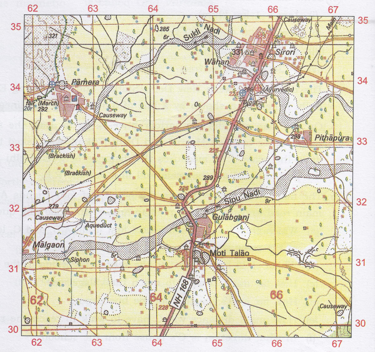
(a) Find the area in sq. km. of the area enclosed within the Eastings 64 to 64 and Northings 32 to 35.
(b) Find the compass direction of the following:
(i) Gulabganj from Pithapura
(ii) Pamera from Malgaon.
(c) Find the direct distance of the metalled road from the Post Office at Pamera till it intersects with National Highway- NH 168 in grid square 6432.
Answer
(a)
Number of complete squares = 3
Since each grid square measures 1 km x 1 km, the area enclosed within the Eastings 64 to 64 and Northings 32 to 35 will be 3 sq. km.
(b)
(i) Gulabganj lies to the south-west of Pithapura.
(ii) Pamera lies to the North-east of Malgaon.
(c)
Distance between them = 4.6 cm
Given scale: 2 cm = 1 km
1 cm = 0.5 km
4.6 cm = 0.5 x 4.6 = 2.3 km